Introduction
The combatants: WalksWithBlackflies, nartreb, MudRat, Puma concolor
The Peaks:
Lower Wolf Jaw - 4175'
Upper Wolf Jaw - 4185'
Armstrong - 4400'
Gothics - 4736'
Saddleback - 4515'
Basin - 4827'
Haystack - 4960'
Marcy - 5344'
The Challenge: Hike 'em all in a day.
Secondary Challenge for WWBF and MudRat: Ascend over 10,000 ft. in a dayhike, scout/photograph slides for future bushwhacks.
The result: Unqualified success for WalksWithBlackflies and MudRat. Puma and nartreb chose to bypass the final summit of the day - Mount Marcy, a 2.4 mile out and back.
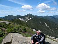
![Great Range Panorama from Dix]() The Great Range
The Great Range
For me, it was an idea that was born in the immediate aftermath of a successful
Presidential traverse (White Mountains, NH) last September 4. I had long been kicking around the idea of doing big one-day classic Northeast traverses but had just never committed myself to action. As I drove home from NH last year with sore legs, blistered feet and an aching back, I knew I was hooked ... addicted to pain, you could say. With the Presi traverse in the bag, the other two big Northeastern classic traverses were calling my name - the Great Range in the Adirondacks and the Devil's Path in the Catskills.
This Great Range hike started to come together several months ago when WalksWithBlackflies created the outstanding
Great Range page for Summit Post. A flurry of Private Messages between WWBF, nartreb and myself confirmed all of our interest in the one day traverse. The rest was just a matter of sorting out details. WWBF's regular hiking partner - Mudrat - was soon part of the equation and we all agreed that a group of four was a good size for the hike. August 12 would be the day.
MudRat
WWBF and I planned this hike prior to Backpacker’s Magazine’s rating of the Great Range as the USA’s 3rd hardest day-hike. So…to be cantankerous, we added Rooster Comb, Pyramid and Haystack to the roster as a way to increase the total vertical ascent to over 10,000 feet. More than that, I hiked to get out in the most beautiful area of the country, in my opinion.
WWBF:
MudRat and I had been planning a traverse for over a year, so when Puma contacted me about doing a Great Range traverse, I jumped at the chance. But as the date approached, I was a little hesitant, because I hadn’t been doing much hiking. I was in good shape cardio-wise, but due to a multitude of reasons, I was only able to ride my bike over the past couple of months, and I didn’t know if my knees could take the pounding of the Adirondack rocky steeps.
nartreb:
I was pretty lackadaisical in my preparation, both in terms of studying the route and in my physical preparation. By the time I snuck out of the office on Friday afternoon I hadn't gotten any exercise to speak of in two weeks, had been sleeping very poorly, and barely knew the names of the mountains I'd be climbing. But I figured it couldn't possibly be much worse than the Presidential Traverse I'd done last year, since it's about the same total mileage and distance. How bad could it be?
The night before
nartreb:
Puma and I arrived separately at Garden Lot around 10PM on Friday night. We'd sleep in our cars, and in the morning leave one behind for our return and take the other one to the Roostercomb trailhead, where WWWBF and Mudrat would have started early in order to have time to hike the spur trail up Roostercomb. This plan gave everybody several minutes more precious sleep in the morning.
I was curled up on my sleeping pad in the trunk of my car well before midnight, and actually slept fairly well. It was a cold night, but inside the car was fine. I did wake up several times as hikers shuffled in from the trail: eleven PM, 1 AM, 3 AM... had they planned to stay out so late or were they taking much, much longer than they expected?
Puma:
Damn! I can't sleep. It's going to be chilly in the mountains. Four liters of Gatorade bouncing against my lower back (broken in 2002) is gonna hurt over the course of 25 miles. Not acceptable. 2 AM. I'm out of my truck playing around with weight distribution. Two liters in the backpack and four water bottles in my coat pockets. Yeah, that works. I hope I don't get too warm in this damn coat. Still no sleep. If I wear shorts and my coat, that should work. Why I am being such a spaz? Just set off my car alarm ... probably woke up nartreb (also sleeping in his car). I just want to get going and burn off this damn energy.
MudRat:
The weekend before found WWBF and I on a 13 mile round trip hike up the
"V" slide on Dix and down the
Hunter's slide. I felt great, so anticipated no problems on the Great Range Traverse. I eagerly awaited as the days crept by. Fridy, I slept like a log once I got to sleep after WWBF got to the house and settled in on the futon. The excitement of the past week had finally dulled from the overwhelming desire to fall into unconsciousness as quickly as possible. Luckily, I had no falling or cripplebrush dreams interrupt my four hours of peace! I anticipated a great day.
WWBF:
There are forces conspiring against me. First, I left work late. Then it took me longer than I anticipated to prepare my food, feed the cats, etc before I left my house. Then I got stuck in concert(?) traffic on the Thruway. Then the on-ramp to Route 12 was closed.
By the time I reached MudRat’s house, it was 10:15.Roostercomb
Section Mileage: 3.0
Section Ascent: 1,770
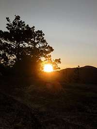
![Rooster Comb Sunrise]() Rooster Comb Sunrise
Rooster Comb Sunrise![Rooster Comb from the Lower Range]() Rooster Comb from the Lower Range
Rooster Comb from the Lower Range![Roostercomb Cliffs]() Roostercomb Cliffs
Roostercomb Cliffs
MudRat
5:00 a.m. start, 5:55 a.m. intersection to RC, 6:05 a.m. summit. The euphoria of the previous week worth of anticipation wore off in the first eight steps after climbing about twelve feet. Four hours sleep and waking at 4:00 a.m. are not conducive to an ambitious beginning for a grueling hike...neither is total darkness. My doubts for finishing the Range assaulted me early on as my breath eluded me. After two miles and at the junction to Rooster Comb, I dropped my pack and fast-tracked the .5 miles to the summit with WWBF. We were greeted with an incredible sunrise and views that rejuvenated my ambitions for the day.
WWBF:
After four hours sleep, I woke up at 4:15 and immediately ate a two-egg omelet and drank 24 ounces of Carnation instant breakfast… and now I felt sick to my stomach. The 15-minute ride to the trailhead eased my queasiness, and by the time MudRat and I signed in at the trailhead at 5:00 sharp, I was feeling fine. I wanted to clear my lungs of the remnants of the cold I had during the previous three weeks, so I set a quick pace up the steep switch-backing trail. After mistaking another hiker’s dog for a skunk, we reached the intersection with the Roostercomb spur, and quickly ascended to a summit sunrise. A few minutes later, we were back at the intersection, where Nartreb and Puma were waiting as planned.
nartreb:
The plan worked flawlessly as we left Garden Lot at 5:00 sharp and found WWBF's car at the Roostercomb trailhead. Luckily Puma drove, as being awakened at that hour was causing me violent gastric cramping. But the brisk morning air soon revived me and we made excellent time up the trail, pausing only to remove the fleece pants that had seemed necessary in the freezing pre-dawn. The day had dawned brightly by the time we reached the Roostercomb spur trail, and we waited only a few minutes before WWBF and Mudrat joined us.
Puma:
5 AM. Finally ready to hit the trail. WWBF and MudRat started 15 minutes ahead of us so they can do the Roostercomb side trail. It's too cold for shorts. On go the sweats. Let's do this! Nartreb seems like a cool guy. Hedgehog
Section Mileage: 1.1
Section Ascent: 1,060
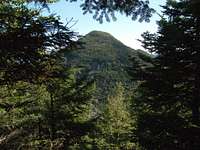
![Hedgehog and Lower Wolfjaw]() Hedgehog and Lower Wolfjaw
Hedgehog and Lower Wolfjaw
WWBF:
The ascent up Hedgehog was steeper than I anticipated, and was definitely steeper than appeared on the topo map. After about 20 minutes of hiking, we reached a ledge with a view back to Roostercomb, and saw that we were no more than a tenth of a mile away. If only we were able to rappel down those Roostercomb cliffs…
MudRat:
Hedgehog was really a section that had me focused on listening to my new hiking partners and catching my breath. We collectively hiked to the next intersection with Keene Valley and Lower WJ by 7:30 a.m. Nartreb made a comment later in the day that he heard my heavy breathing behind him (DON'T go in the wrong direction with that one), and wondered if I'd make it through the day. I was probably still wondering the same thing myself. I think I remember saying a prayer that Hedgehog would magically turn into Lower Wolf Jaw, but that could have been a hallucination as well!. I do remember the sun illuminating the trees...the rest, other than the pitch, is fuzzy due to the early morning start.
Puma:
Nartreb and I meet up with WWBF and MudRat at Hedgehog Junction. We've only been hiking together for a mile now but this seems like it's going to work. Hedgehog Mountain is just an intermediate bump on the way to Lower Wolf Jaw. The most memorable part of Hedgehog is the view back at Roostercomb - very impressive rocky summit.
Nartreb:
So far, so good. The trail was damp and often eroded, but basically just a hilly walk in the woods on a cool day. From the col we had an obstructed but dramatic view of the Roostercomb cliff shining in the dawn (I made a feeble effort to find a clear view for a photo, but didn't want to slow down yet), but really nothing to write home about here. The most notable thing about Hedgehog was that it provided our last water until the Haystack col. I chugged about half a liter here and filled up my previously-empty spare bottles. At about three liters, I was carrying the least water of the group. For me, it would be critical to keep clothing and pace properly adjusted so I'd never sweat any more than necessary.Lower Wolfjaw
Section Mileage: 1.9
Section Ascent: 1,140
![True Summit of Lower Wolfjaw]() True Lower Wolfjaw Summit
True Lower Wolfjaw Summit
WWBF:
The hike up Lower Wolfjaw was steep as expected. What I hadn’t expected was how thin the ridge was up to the false summit. Not a knife edge by any means (as reported in Backpacker magazine), but it was the thinnest ridge I’ve been on in the Adirondacks. On the way down, I used my trekking poles to lessen the pressure on my knees. It didn’t work… the terrain was too rugged and steep.
MudRat
8:30 a.m. summit: Steep...steep...steeper. I'd been on Lower Wolf Jaw before, with my (now) wife, "Crazy Dog"; but didn't remember the views being as beautiful as they were...mostly due to the state of delirium I was in last time! I also descended the northern side during the last hike and vividly remember saying, "I'm glad I don't have to hike up this!!", in reference to a nearly vertical scramble near the summit, or false summit. I also started taking scouting photos of nearby slides for future hikes. The brisk air, realization of our first real summit and good company invigorated me and gave me the "umph" to begin the push forward again. A large fraction of our overall ascent had also been completed.
Puma:
As we break above the magical 4,000-foot mark, the views start to become more consistent. I'm still trying to get my bearings. Haven't been hiking back here since my round of the 46Rs in the early to mid 90s. WWBF and MudRat have been through more recently and both have good memories of this section of trail.
nartreb:
This one is just a blur in my memory - we'd been hiking a few hours already and I was getting impatient for a proper treeline. I had about convinced myself that this hike was going to be easy. Yeah there were some scrambly sections which would have been ugly in the rain, but nothing you wouldn't expect on any Northeastern peak.Upper Wolfjaw
Mileage: 1.4
Section Ascent: 800
![False Summit of Upper Wolfjaw]() False Summit of Upper Wolfjaw
False Summit of Upper Wolfjaw
WWBF:
Upper Wolfjaw is only 20 feet higher than Lower Wolfjaw. The problem is the steep 700-foot col between the two. I had done a partial Great Range traverse two years prior, so I knew that the next nine miles would be exactly like this… hundreds of feet straight up followed by hundreds of feet straight down. On the descent, I decided to forego my poles in favor of using my arms to lower me down the ledges.
MudRat
9:50 a.m. summit: Lovely views and and another excuse to eat and drink. Previous hikes have always found me with a pounding headache. In retrospect, I finished this without one...attributable to 1.5 gallons of water. Anyway, the eat-drink theme was present and as dominant as photography on each peak. I was starting to warm up inside from the previous 6 miles and cool down outside from the constant wind blowing every time the trees parted.
Puma:
I'm huffing and puffing like a freight train on the uphills. My legs are feeling good but trying to hike at the pace of others through steep sections feels awkward. I feel more comfortable setting my own pace and breaks. I start pushing ahead a bit as we near the summits, giving myself a few extra minutes break time at the peaks. I keep up this trend most of the day.
nartreb:
OK, that col was pretty significant - but I was expecting one or two of those. We were making very good progress on the map, so it was a good time to stop for breakfast. There was another hiker on the summit and he was in a chatty mood, but I was concentrating on chewing my bagel sandwiches and soaking up the warm sunshine. This is as good a time as any to mention the variety of food and equipment we carried: in addition to customary items like trail mix there were whole bananas and a couple of pounds of pound cake. Clothing ranged from shorts and T-shirt to windbreaker and sweat pants. I think the others were pretty jealous of my top-of-the-line Broomstick 3000 trekking pole with Adjustable Grip.Armstrong
Section Mileage: 1.0
Section Ascent: 500
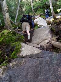
![Typical Ascent on North Face of Armstrong]() Typical Ascent up Armstrong
Typical Ascent up Armstrong
![The View Ahead]() The way ahead
The way ahead
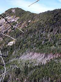
![Fir Wave on Gothics]() Fir Wave on Gothics from Armstrong
Fir Wave on Gothics from Armstrong
WWBF:
Armstrong looked very intimidating from the col… and indeed it was very steep. However, I was feeling very good, and I love scrambling. At the summit, we had our first glimpse of the Upper Range. I couldn’t take my eyes off Gothics, which appeared to tower over us.
MudRat:
10:45 a.m. summit: You've gotta love any ascent up what looks like a vertical monster that starts up a shear cliff via a ladder. Need I say more? Ok, I will. This was a steep climb, very steep to a rewarding view of Gothics and the Upper Great Range. As we'd experience each mile or so, the brutal ascent broke the agony of the prior descent and visa versa. On the south side of Armstrong, a break in the trees unveiled the beautiful slides of Gothics and a large fir wave.
nartreb:
This is where I finally realized what I'd signed up for. The scramble up wasn't the sort of thing a rock climber would even deign to notice, but I hadn't done any climbing, or even any scrambling, in months, and it drained me. I started paying more attention to the map, hoping we might already be on Gothics. No such luck. On the other hand, I finally started getting those above-treeline views I'd been wishing for, and the weather was excellent. Views are like oxygen, and I soon regained my energy.
Puma:
The Upper Wolf Jaw to Armstrong col proves to be the easiest of the day. That's not to say, however, that the hike up Armstrong isn't steep. The climbing just ends sooner than on most of the other climbs. Atop the summit of Armstrong is when the majesty of the Great Range really hits you. The plunging slides of Gothics to the southwest are a sight to savor. What a perfect day for this traverse. Cool and sunny with strong winds above treeline.Gothics
Section Mileage: 0.9
Section Ascent: 500
![Resting]() resting
resting
![Looking back at Gothics]() Gothics from Saddleback
Gothics from Saddleback
WWBF
After a relatively short descent, we began the long climb up the north ridge of Gothics. Although we were ascending at a respectable 40 vertical feet per minute, I was feeling strong and the pace seemed almost slow to me. I wasn’t going to complain though, because I knew we still had a long hike ahead of us, and I’d probably burn out at the pace my legs wanted to propel me. It was great reaching treeline… the air just feels different up there.
MudRat:
11:45 a.m. summit: I can't believe I'm writing this, but it was an easy hike up Gothics from the col. That's why WWBF and I did it twice from different directions this day and 3 other times in the past! Just kidding there was another reason...to view Pyramid (and a healthy dose of stupidity). Views are beyond incredible from here to Marcy. The descent found us on the exposed rock & (not compared to some recent slides, though) cable assisted side of Gothics. WWBF and I refused to lay our hands on the cable just for the principle/fun of it.
nartreb:
I was still a little unsure of my location - counting the peaks between myself and Marcy, looking at their steep slopes, and thinking "that can't be right." Oh well, I was committed, might as well relax, enjoy the views, and stop worrying about the time slipping by and my pace that was already starting to slow. But an additional trip to Pyramid? "You mean today?" I'm not that crazy, thank you.
On the way down Gothics I grabbed the cable a few times - it wasn't necessary, and it required an uncomfortable crouch, but it was a nice psychological boost, especially when my Broomstick 3000 slipped on the smooth rock.
Puma:
What a difference a decade makes! Either my memory of my two climbs of Gothics during my round of the 46 is completely skewed or there has been a lot of vegetation growth on this peak in the last 12 years. I remember an essentially bald peak with almost no alpine vegetation. While this is still a very open summit, there are now significant areas of arctic alpine tundra growth. Nartreb and I linger on the south summit while WWBF and MudRat trek over to tag the "Pyramid" for extra credit.Pyramid
Section Mileage: 0.6
Section Ascent: 400
![Classic shot of Basin from Pyramid]() Classic shot of Basin from Pyramid. This is the power of nature...so amazing.
Classic shot of Basin from Pyramid. This is the power of nature...so amazing.
WWBF:
Knowing that Nartreb and Puma were waiting for us on the south summit, I set a quick pace down to the col, and up to the Pyramid summit. The change of pace felt great. This is my favorite summit view in the Adirondacks, and it did not disappoint on this crystal clear summer day. On the way back, MudRat continued the quick pace, which I clocked at 60 feet per minute.
MudRat:
11:55 a.m. summit: As we briefly parted ways, Puma astutely noted that, though we were all insane, WWBF and I were actually in straight jackets. Well, "If the straight jacket fits, wear it," as they say. We dropped packs and basically jogged south to Pyramid to add to our ascent and fire off a few photos of what boasts better views than Gothics, in my opinion. I will admit that the run BACK up Gothics tore me down and bit and I re-invigorated myself with food and water as I did on every peak thus far.
Saddleback
Section Mileage: 1.1
Section Ascent: 600
![Descent]() descent
descent
![Saddleback from Basin s Ascent]() Saddleback from Basin's Ascent: Symmetric cliff and slide
Saddleback from Basin's Ascent: Symmetric cliff and slide
WWBF
Being a newly initiated exposure junkie, I was looking forward to the descent of the Gothics “cable route” to the Saddleback col. But my shoes had picked up sand and mud, and I found the footing tricky. However, I was able to navigate down without using the cables (but I see where they would be very useful when the slab is wet). By the time Nartreb and I reached the col, MudRat and Puma were gone. The ascent of Saddleback kicked my butt. My legs felt heavy and burned with lactic acid, and I was breathing heavy but wasn’t able to quite catch my breath. I was beginning to regret my side trip to Pyramid. I ate, drank, and rested on the summit, but couldn’t help staring at the enormity of Basin, and thinking that we had 1,000+ foot ascents of Haystack and Marcy after that. At least I had the descent of the Saddleback cliffs to take my mind off the daunting task ahead of us.
MudRat
1:00 p.m. summit: Saddleback...hmmm. One of my favorite mountains once on top. I was really looking forward to the summit from a photographic perspective and it didn't disappoint me. It was, however, one of the lowest points in the day. I'd descended gothics (without touching the cable with my hands) in short order and gotten far ahead of nartreb and WWBF. I caught up with Puma and we started the slow, constant painful trod up and up and up and....It never seemed to end and forced me to take several breaks to regain my breath. As I look back, it was identically as difficult as when I hiked it years prior. The cliff side descent was invigorating and beautiful, but with a back offbalancing me, the wind destroyed my balance on more than one occasion.
nartreb:
After being left far behind on the descent of Gothics, I started out in the lead descending Saddleback. WWBF gave me some good advice: "stay right on top of the blazes." Indeed, the "trail" weaves a nearly miraculous line down a respectably vertical cliff, a route that, except for the blazes, is totally invisible from just a few feet off-course. Give yourself ample time if attempting to follow this route in winter or in poor visibility.
Puma:
It's past noon now as we descend steeply down the cable lines from Gothics. We've already done a lot of work for the day and it starts to become obvious that this will be a very long journey. Can we make the distance before dark? I'm not sure, but this epic hike is surely turning into a day to remember. The Gothics/Saddleback col is a killer but we make very good time. I think we reach the peak a little after 1 PM.Basin
Section Mileage: 1.5
Section Ascent: 700
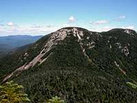
![Basin From Haystack]() Basin from Haystack
Basin from Haystack
MudRat:
2:15 p.m. summit: The Ascent to Basin from Saddleback is a frustrating hike of yet more scrambles etc. as the rest of the range including two large false summits. On a positive cardiovascular note, it's similarity to Saddleback's ascent is eased by the false summits. They are a paradox: respite as well as looming threat of pain! The summit is magnificent and worth anything short of death. Excellent views of the 90's slide on Colden, the Mid-Great Range, Haystack and Marcy's promise of a finished journey (halfway at least) greeted my weary eyes. The descent was a fun extended scramble/walk. A large cliff face met WWBF and I halfway down. The path by-passes this. We went down it. I did not years earlier. Down, down, down, we went. This meant one thing...up, up, up was next!
WWBF:
Looking up at the FALSE peak of Basin from the col, I swore I heard the mountain laughing at me. MudRat and Puma took off ahead, as Nartreb and I slowly ascended. Being the shortest members of the group, we both had some difficulty on certain ledges, but eventually found a way up. Although we were moving slowly (our pace was down to 20 feet per minute), we only rested once on the way up. After a significant “lost time” experience, I found myself on the summit where I inhaled food and gatorade. The descent of Basin, although it remained insanely steep, was actually easier than I had expected, and before I knew it, we had reached Haystack Brook.
nartreb:
Fatigue was seriously setting in - I felt OK but I was really slowing down, especially on the descents. I don't remember Basin much, except the one boulder on the ascent where I was leaning on a dead tree, got one foot up, and needed WWBF to push the end of my hiking pole to give me the momentum to get the other foot in place without losing my balance. (WWBF solved the same problem with a nifty spin move.) I prefer "graceful piroette" --- WWBF
Puma:
I have long considered Basin to be one of my favorite summits from my 46R days. I had camped at Slant Rock in 1994, making an early morning ascent that took me exactly to the cloud line. I can still vividly remember standing on Basin and watching a small cloud form on Mount Haystack and approach me, eventually passing right through me. It felt at the time as if I were in an airplane. Truly a surreal experience. Today, during the traverse, Basin is no less magnificent but I am perhaps too focused on managing my fatigue, the time and water intake to appreciate it as much as I did on that morning many years ago. This is peak #6 for the day but the deep cols left between Basin/Haystack and Haystack/Marcy leave it clear that we are hardly in the homestretch.Haystack
Section Mileage: 2.7
Section Ascent: 1,450
![Little Haystack and Haystack]() Little Haystack and Haystack from Marcy
Little Haystack and Haystack from Marcy![Little Haystack]() Puma and MudRat on Little Haystack
Puma and MudRat on Little Haystack
MudRat
4:15 p.m. summit: Haystack is one of my favorites...one giant scramble. The walk from the col of Basin up the ridge was a new trail to me, a grueling rock hop up at this late hour (about 4:30). My pace was definately slowing, dramatically. I stopped mid-trail to eat and stop the shakes. After a brief time, I was ok, and found we were only minutes away from Little Haystack. The wind was incredible! I scrambled up an alternate route on Little Haystack on the way FROM the summit being neurotically careful not to touch the fragile alpine vegetation. As I stepped up from the crag and assumed a standing position, I found myself on all fours, again. The wind had knocked me off my feet (or the mountain moved)! Oh, well, no harm done, I just learned to walk the week prior, anyway.
WWBF:
Something magical happened in the col… I found a perfect sittin’ log, closed my eyes, and fell asleep. I only slept for about two to three minutes, but I woke up rejuvenated. I knew that this section of trail was more of a rock-hop than scramble, and I enjoyed the change. To say that I had no difficulty ascending to Little Haystack would be an understatement... it felt like I was on a leisurely neighborhood stroll. Just before climbing onto the exposed rock of Little Haystack, I donned my long-sleeve shirt and wind pants. Good choice, because the wind was whipping at around 40-50mph. I soaked in the view of Panther Gorge from the true summit, which in my opinion, is the second best view in the Adirondacks. We retraced our steps over Little Haystack, and then descended down, down, down into the col. I was still feeling very good, and my knees didn’t hurt at all. Using my arms to descend instead of poles was definitely the right choice.
nartreb:
Haystack was a blast. Barren rock, stunning views, and Little Haystack hiding the true extent of the distance and height remaining, until I was fully committed (plus I couldn't possibly turn around in front of a group of kids). The wind threatened to knock me off balance once or twice, but for the most part it lifted me up the hill and cushioned my descent. I was tired as hell, and not sure what time I'd ever get to bed, but finally, finally, I was well and truly above treeline on a spectacular day. Hiking doesn't get too much better than this - not in the Northeast, anyway.
Puma:
Wind, wind, wind. What more is there to say? Not a particularly difficult ascent from the col in spite of well over 1,000 feet of gain. The gusty wind on one of the most open summits in the Adirondacks, however, is just about knocking us over. Marcy's summit to the west seems almost close enough to touch. Yet a small obstacle in the form of Panther Gorge means we will have to take the Dennis the Menace route to get there.Marcy: The Cloudsplitter
Section Mileage: 1.7
Section Ascent: 1,200
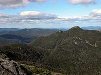
![Marcy from Haystack]() Marcy from Haystack
Marcy from Haystack
![Marcy s Summit]() Marcy's Summit: Notice the revegetation zones cordoned off by string and stones.
Marcy's Summit: Notice the revegetation zones cordoned off by string and stones.![A Cairn on Marcy]() Cairn on Marcy
Cairn on Marcy
MudRat
6:30 p.m. summit: After a half mile of descending from Haystack/Little Haystack we reached the trail intersection. Up went to Marcy (1.3 miles) and down went to comfort (9 miles). Nartreb and Puma opted out at this point. WWBF and I opted the opposite. I believe I probably regretted it, though, somewhere on the way up. Nartreb paid us the highest compliment and our all-time favorite quote of the day at the intersection..."You guys are F**king INSANE!"
From the bottom of our hearts, "Thank you!" I'm still smiling from that one.
The Summit: What can I say, but, "Wow, WE MADE IT!." Failure was never an option after the initial hour for me, but the temptation was always whispering, "GET OUT NOW, WHILE YOU STILL CAN!" The weather had cleared to near perfection with puffy clouds that gave depth to the scenery. Last time on Marcy, I froze. This time, it was cool, but comfortable and a photographer's paradise with my best friend. We both made multiple attempts to call our spouses and finally got through. "Hi, love, we're just on Marcy....yup, it's a little later than expected...oh, we'll probably be out by midnight, it's only a 10 mile hike...yup, we've got our headlamps...Deb, stop laughing."
One rhetorical question to anyone who reads this, "How does a cell phone jump from 5 bars to 1 without moving the phone?"
WWBF:
Once at the col, Puma immediately notified us that he was done. Nartreb was a little more hesitant, but finally stated that a 1,400-foot ascent of Marcy at the end of a long day was “ridiculous”. I gave my keys to Nartreb so that he could drive my car from the Roostercomb trailhead to the Garden, thus saving MudRat and I a two-mile hike down the asphalt road (THANK YOU Nartreb and Puma). I was still feeling strong on the ascent, and once we reached treeline, I got an extra adrenalin boost. I grabbed my last sandwich and ate it on the way up, much to the amazement of MudRat, who couldn’t understand how I could breathe and eat at the same time. Once on top, we congratulated each other… but at the same time, noticed how far away the trailhead looked. Our hike was not over. Not even close.
Puma:
The trail junction sign comes into focus. "Mount Marcy 1.2 miles - elev. 1244; Keene Valley 8.8 miles." I look at my watch. A few minutes after 6 PM. I don't like the math but give it all a moment to sink in before speaking. All I can think of is the painful final three miles of descent in the dark during my Presidential traverse a year ago. By the time I was done, almost all of my toe nails were obliterated. If I climb Marcy, we'll probably get back to this junction just a few minutes before nightfall. Eight miles of descent by flashlight at the end of a long day? No thanks.
"I'm out," I announce matter-of-factly. I explain my reasoning and am comfortable with my decision. I've essentially completed the traverse and though Marcy would have been the icing on the cake, I don't second guess myself. Nartreb decides to follow suit. We make arrangements to shuttle WWBF's car to the Garden Lot and bid our farewells. MudRat and WWBF head up; Nartreb and I head down.
nartreb:
Having been sucker-punched by the deep cols of this range, I was seriously worried about getting out before dawn in case the descent trail, like every other trail so far today, proved more difficult than the map indicated. Add in hours of driving, and I wasn't sure I'd have time to recover before Monday. I knew I was the slow link that day, and I didn't fail to notice WWBF exploring new scrambling routes on Little Haystack as if he'd just stepped out for a short stroll. As I write this, I regret my decision to bail - I know I could have made it, and it wouldn't have killed me to be a little sleep-deprived on Monday.
Death March to Garden
Section Mileage: 9.1
Section Ascent: -3,820
WWBF:
One million footsteps
Trailhead still ten miles away
This is gonna hurt
Upon our arrival at John’s Brook Lodge, I crashed on one of the Adirondack-style chairs, and wondered just how I was going to make it the final 3.5 miles. Ten minutes prior I was on the edge of exhaustion-related delirium. I had absolutely nothing left. I closed my eyes, and immediately fell asleep. Again I only slept for a couple of minutes, and upon waking, decided we better get moving lest I fall asleep permanently. When I stood up, everything in my body hurt. However, after a couple of minutes of hiking, I wasn’t feeling bad. I wasn’t feeling good, but not bad either. MudRat and I were actually making good time, despite hiking by headlamp. I COULD DO THIS!!! I made a joke, saying that since we’d be hiking 19 hours straight, why not head up to Big Slide and make it a true 24-hour dayhike. It was not well received. Based on my projections, we should have reached the trailhead at 11:37. After 11 more agonizing minutes (What if I miscalculated our pace? Were we still two miles from the trailhead?), we reached our destination. But I was not going to count my blessings until I saw my car (What if Nartreb couldn’t start the car? What if he lost the keys? What if they just decided to abandon us?). In hindsight it makes perfect sense, but after 19 hours on my feet, I thought it was a cruel joke that Nartreb parked the car on the far side of the parking lot.
Puma:
Overdressed all day
Soaking through straight to the bone
I could use dry clothes
The similarities to last year's Presidential traverse race through my mind as this hike winds down. Last year, I had hiked for 16 hours, bagged 7 of the 8 official 4,000-footers (no Mount Jackson) and descended the final three miles in the dark. This year ... ditto. Well, nearly a carbon copy, that is. By the time Nartreb and I step out of the woods just before 10 PM, our time on the trail is closer to 17 hours. But like last year, I had tagged 7 of the 8 46R peaks (opting out of Mount Marcy) and hiked the final three miles from the DEC Interior Outpost at John's Brook by flashlight. A great day with great partners. One of my all-time favorite days out on the trail. Somewhat paradoxically, at the end of it all, I am exhausted but still feeling strong.
nartreb:
Full moon, creaking trees
Flashlight ahead stops, aims left
You heard the growls too?
For the most part, the whole descent really was uneventfull, and the trail was mercifully smooth. But as my haiku describes, one incident was quite eerie. About a mile from the trailhead I began to hear a strange rumbling off to my left. It was an extremely low-frequency noise, so deep it was almost inaudible; the image of an underwater rockslide came to mind. It was hard to say exactly where it was coming from, and even if I'd had a brighter flashlight I wouldn't have been able to see more than a few dozen yards through the trees, but it seemed to be about even with my position. Thinking of bears, I picked up my pace a bit, but didn't want to "act like prey" by running; instead I swung my Broomstick 3000 over my head and behind my back, and whistled whatever tune sprang to mind (and looked over my shoulder quite a bit - the empty trail behind me would have provided a perfectly silent attack route). I was making good time on a smooth trail, but every time I heard the noise it seemed to be keeping pace with me, always off to my left. I soon caught up with Puma, who was pointing his lamp to his left to a spot well ahead of me: he'd heard it too.
If it really was moving as fast as it seemed to be, it was doing so incredibly silently (except for the growling). Another explanation, though not a reassuring one, is that the noise only seemed to keep pace with us because it was much farther away than we thought - and also much louder than we realized. Finally, it might have been several separate noise sources - some rare species of frog? But why would they only be heard one one side of that one section of trail?
Mudrat:
Sensations of pain
Shot at...missed, sh*t at and hit
WE DID IT!!! and died
7:30 p.m. back at intersection with trail to Haystack,
8:55 p.m. Bushnell Falls,
9:50 JBLodge,
11:48 finish hike at the Garden:
As WWBF and I rested at JBL watching the beginning of a meteor shower and letting our swelling feet rest, we discussed the last section of trail...3.5 miles to the Garden. God plays a funny trick in this area, seemingly bending time and/or mileage while increasing pain. It's been consistent all four times that I've hiked or limped it. 11:48 and WWBF's car were beautiful things as our mission ended and recuperation began.
By the way WWBF, I was really hoping to meet my spirit animal as you thought we might during that trog!
I think Nartreb and Puma heard it! --- WWBFFinal Thoughts
WWBF and MudRat
Total Mileage: 26.0
Total Ascent: 10,120
Puma and Nartreb
Total Mileage: 21.4
Total Ascent: 8,220
This was one of the most incredible hikes I've taken. The Adirondacks is my backyard...literally. The Great Range is the epitome of our most rugged area created by the incredible beauty of nature’s life giving forces and destructive mechanisms. To experience all in one day with crisp weather, was a once in a life-time journey. On a humorous note, what does it take for a hypoglycemic with a fast metabolism to hike 26 miles on a cool sunny day?...
1 protein drink in milk
2 raw eggs
2 omelets (each made with turkey, bacon, 4 cheeses and 4 eggs)
2 turkey and cheese sandwiches
¼ lb of trail mix
3 yogurts
3 bananas
2 protein bars
2 granola bars
several pieces of WWBF's pound cake
6 liters of water and
10 tons on insanity!
I pushed beyond what I’ve ever done and set new limits…only to ask, “What can I add to it now!!!???”
nartreb:
Puma had very kindly provided for me to sleep on his couch, so I'd only have to drive about a hundred miles instead of about three hundred. Driving there was still the most dangerous and stupid thing I've done in a very long time, as I had great trouble keeping my eyes open. Next time I'm planning to sleep at the trailhead for another night. Oh yeah, I said "next time" - and that's not counting a grudge match with Marcy in the fall or winter, another one-day Presi Traverse while there's still daylight this September, and maybe a one-day Pemi Loop as a warm-up in the spring.
Though I was probably in better shape last year when I did the Presis, I am convinced that the Great Range Traverse is more difficult than the Presi Traverse. The total distance is about the same, and so is the total elevation, but in the Great Range most of the elevation is close to vertical. You simply can't maintain a fast pace. I think it took me as much time to reach the summit of Haystack as the entire Presi Traverse (twice that distance) had taken me.
Puma:
Devil's Path this time next year! Anyone interested? Bueller, Bueller...
Count me in --- WWBF
WWBF:
All I have to say is that it is the closest I’ve ever come to a total physical and emotional breakdown. It was great!


Comments
Post a Comment