

-
 8458 Hits
-
 83.69% Score
-
 17 Votes
|
|
Mountain/Rock |
|---|---|
|
|
47.51050°N / 10.91630°E |
|
|
Hiking |
|
|
6736 ft / 2053 m |
|
|
Overview
 Hiking Schellschlicht .....
Schellschlicht is a moderately rugged Ammergau peak with a distinctive bowl between two ridges on its southern flanks and with a northern ridge, which is a sort of backbone of the mountain, continuing to the north with Austrian Kreuzspitze (or Kreuzspitzl), German Kreuzspitze, Kuchelbergkopf and Kuchelbergspitz.
The southern bowl contains many little creeks which are accumulated to the Schellaine creek, cutting a deep valley and a canyon into the limestone of southern Schellschlicht.
The two southern ridges can be named after their subsummits: Sunkenkopf ridge to the southeast and Brandjoch ridge to the southwest. Marked trails on the two ridges allow for a nice loop hike to the summit and back. Views are extensive, especially of the Wetterstein walls to the south, looking across the Plansee to Reutte on the west, and a view north into the heart of the Ammergau range, dominated by the Geierköpfe and Kreuzspitze.
The hike is likely popular in late or early season because both trails are on southern slopes of meadow and latschen, where snow will not linger. At over 1200 meters elevation gain from the valley, it's good to get an early start if you come in high summer.
Getting There & Main Routes Overview
 The enjoyable Southwest Ridge.
From Garmisch, continue west about 10 minutes on the B23 to the little village of Griesen (elevation 816 meters). Park your car here at a gated forest road, signed for Schellschlicht and the Plansee, or cross the creek and use the hikers parking area south of the road.
Southern approach
Hike up the road (number 251, 252) into Naidernach valley (which leads to Plansee - MTB route) about 15 minutes, until signs for Schellschicht point up an abandoned side road on the right. Climb up from the valley floor, crossing light woods, on road then on trail to reach a signed junction between the two trails to the summit.
Southwest Ridge (Brandjoch ridge)
The left alternative crosses the beautiful gorge of Schellaine on a metal bridge, then heads up in many switchbacks through forest to reach Schellalm, a seasonal Alm hut. Above this, the terrain opens up, and you travel on the ridge top in northern direction to Hohe Brand and finally Brandjoch, making slight descents at times. At one point below Hohe Brand - a dwarf pine hill, there is a little metal ladder in the rock to scramble up (about 3 meters high).
At Brandjoch the ridge bends to a more northeastern direction. Follow the rodge up to the summit. Little and easy rock scramble near the summit block is required. Great views.
 Secured rock scramble on the southwest ridge route Secured rock scramble on the southwest ridge route |  Great views to Wetterstein from the southwest ridge route Great views to Wetterstein from the southwest ridge route |  Upper southwest ridge route Upper southwest ridge route |
Southeast Ridge (Sunkenkopf ridge)
The right alternative also goes up through steep forest, then traverses a rugged hillside on a narrow path and zigzags up very steep gras slopes to a col, point 1672 m, between Sunkenkopf and Schellschlicht. The trail follows the upper southeast ridge, avoiding rugged poiunt 1884 m by descending and then traversing that huge rock on its southwest side (pay attention to the withered markings, don´t climb that rock by following unmarked foot trails!). A head for heights is required, as the way leads over loose rocks on a narrow ridge to the summit, where it ends abruptly.
 Upper southeast ridge route and summit Upper southeast ridge route and summit |  Upper southeast ridge route and Sunkenkopf as seen from the summit Upper southeast ridge route and Sunkenkopf as seen from the summit | 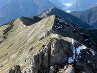 Upper southwest ridge route and Brandjoch as seen from the summit Upper southwest ridge route and Brandjoch as seen from the summit |
North Ridge
 North ridge with Kreuzspitzl and its west ridge and - behind - Kreuzspitze
A wilder route exists, going from the parking area of "Bei den Sieben Quellen" between Linderhof and Hotel Ammerwald to the Neualmsattel (1666 meters) and then up to Kreuzspitzl summit. Near the summit of Kreuzspitzl, the west and the south ridge of Kreuzspitzl join. Below that junction leave the west ridge trail and traverse to the col between Kreuzspitzl and Schellschlicht. Climb the north ridge up to Schellschlicht summit (UIAA grade I to II-). Lonely, unknown and unusula route - fun though!
Red Tape & Accommodation
 Schellschlicht south face
Schellschlicht is part of the German Ammergau Alps nature protection reserve with the usual restrictions like fire, camping, littering prohibited.
You find accomodation at:
No mountain huts are in this region.
Gear & Mountain Condition
Schellschlicht is a late spring, summer and autumn hike on sometimes steep trails which are marked sufficiently. Both routes need some short and easy rock scramble, the southwest ridge "rock part" is secured.The traverse of the summit block has one 5 m high rock with UIAA grade I+.
The north ridge needs rock scrambling up to UIAA grade II-.
You need normal hiking gear and good shoes.
With snow the north and the southwest route is not recommended.
Current Weather:
Summit views
 Looking to the Geierköpfe, a great hike of its own.
 Kreuzspitze in the background, the highest peak of this grouping.
 The Wetterstein and Mieminger Kette from the summit.
 Looking west to the Plansee (mostly hidden) and Reutte.
Map & Guide Book
 Lonely and sunny Schellalm - inviting to a break ...
Maps
Guide Book
Alpenvereinsführer alpin
Allgäuer Alpen und Ammergauer Alpen
Bergverlag Rother, München, 2008