Overview
![Königsangerspitze above the town of Brixen / Bressanone]() Königsanger Spitze above Brixen / Bressanone Königsanger Spitze above Brixen / Bressanone |
Some mountains, while technically undemanding, can become a challenge through their accessibility (or lack thereof). Königsanger Spitze / Monte del Pascolo in the eastern
Sarntal Alps is one of these, though it might depend on the route over which you tackle it. The mountain is, together with its lower neighbour Hundskopf / Monte Cane, the easternmost outpost of the Sarntal Alps high above the town of Brixen / Bressanone in South Tirol / Alto Adige. The town is located at some 600m of elevation so that nearly 2000m separate the mountain from the town. Moreover, Königsanger Spitze lies at the end of a ridge, which stretches out eastward from Kassianspitze / Cima San Cassiano and Lorenzspitze / Cima San Lorenzo between the Schalderertal and Latzfonser Tal Valleys. The distance to the heart of the Sarntal Alps measures some 4km so that the mountain really deserves the name of "outpost".
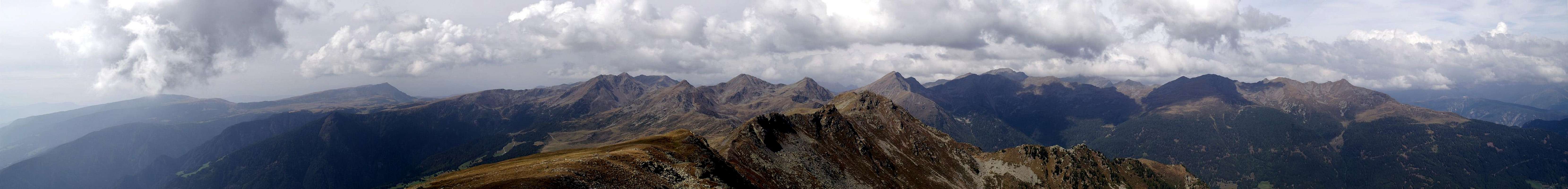
When it comes to views, there is hardly a mountain which offers better ones than Königsanger Spitze. Its exposed location, high above three profound valleys, offers a great overview over the mountain groups around. Therefore, right on its summit, an observation point has been built where all the mountains in the vicinity are named and shown. Most of the vista in the west is dominated by the Sarntal Alps while the western Dolomites dominate the eastern and south-eastern part. The Zillertal Alps are visible a bit farther away in the north-east.
As a result of the enormous difference in elevation from the valley floor to the summit, Königsangerspitze is at the limit of what can be reached during a day tour. The closest trailheads are all halfway up the mountain at about 1000m - 1200m. Thanks to the exposed location on the eastern ridge the mountain can be reached from three sides: Bad Schalders in the north, Schnauders in the south-east and Latzfons in the south. Two huts can be used as base for the climb, Radlseehütte / Rifugio Lago Rodella directly at the base of the summit block and Klausener Hütte / Rifugio Chiusa some 3km to the west.
Effectually Königsanger Spitze is mostly climbed as an afterthought to a visit to Radlseehütte. The hut is based to the east of the mountain, some 150m beneath the summit, at the shore of Radlsee / Lago Rodella. From there the final ascent takes about 15 - 20 minutes and follows the north-east ridge of the mountain.
Summit Panorama Sarntal Alps
Rittner HornSattelbergVillanderer BergJocherer BergRitzlarspitzeKassianspitzeGertrumspitzeLorenzspitzePlankenhornGaißhornGißplatteSchrotthornLeierspitzeLiffelspitzeJakobspitzeMuckleitenTagewaldhornMarchspitzeKasebachhörndlSchneelahnspitzeKarspitze ![]() |
Summit Panorama Dolomites
Summit View Königsanger Spitze: Western Dolomites. Hide / Show labels |
Getting There
All three trailheads are close to the Eisack Valley / Valle Isarco and thus can be quickly reached using the Brenner Motorway A22.
- Latzfons Trailhead
Leave the Brenner Motorway at the exit Klausen /Chiusa. Take SP74 to Feldthurns / Velturno, where you switch to SP 142 in direction of Latzfons. After 1km in Verdings / Verdignes turn right in the direction of Garns / Caerna. Drive through the hamlet and about 500m afterwards you reach a bar and a parking lot.
- Schnauders / Snodres Trailhead
Also leave the motorway at Klausen 7 Chiusa and take SP 74 direction Feldthurns / Velturno. There take SP143 in direction Schnauders / Snodres. At Oberschnauders, near the Zoler Farm there is a small parking lot.
- Schalders / Scaleres Trailhead
Leave the motorway at the exit Brixen / Bressanone. Take SS12 south until you reach Vahrn / Varna. Here drive through the village up into Schalderer Tal Valley. There are several trails from the valley, either across Hundskopf / Monte Cane or along Schrüttensee / Lago Gelati in the back of the valley.
Red Tape
I don't know of any red tape in the region. The area is used for cattle and sheep grazing and there are quite many farms in both the Latzfons and Schalderer Tal Valleys.
Accommodation
Rooms and Apartments
Huts
![Radlsee hut]() Radlseehütte / Rif. Lago Rodella
Radlseehütte / Rif. Lago RodellaWeather Conditions
Maps & Books
Maps
- Digital Maps
- Regular Maps
- Sarntal/Val Sarentino
Kompass Map WK 056
1:35.000
ISBN: 3-85491-340-0
- Brixen / Bressanone
Kompass Map WK 56
1:50.000
ISBN: 3-85491-063-0
- MONTE SARENTINI / SARNTALER ALPEN
Tabacco Map 040
1:25.000
Books
- Rund um Sterzing
Henriette Klier / Walter Klier
Rother Verlag
ISBN: 3-7633-4167-6

 8363 Hits
 84.82% Score
 19 Votes
 Königsanger Spitze above Brixen / Bressanone
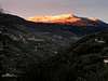


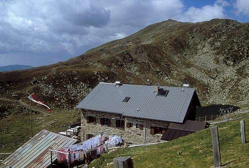 Radlseehütte / Rif. Lago Rodella