
-
 47769 Hits
-
 93.81% Score
-
 44 Votes
|
|
Area/Range |
|---|---|
|
|
35.24253°N / 24.77348°E |
|
|
Hiking, Mountaineering, Trad Climbing, Sport Climbing, Scrambling, Canyoneering |
|
|
Spring, Summer, Fall, Winter |
|
|
8058 ft / 2456 m |
|
|
Overview
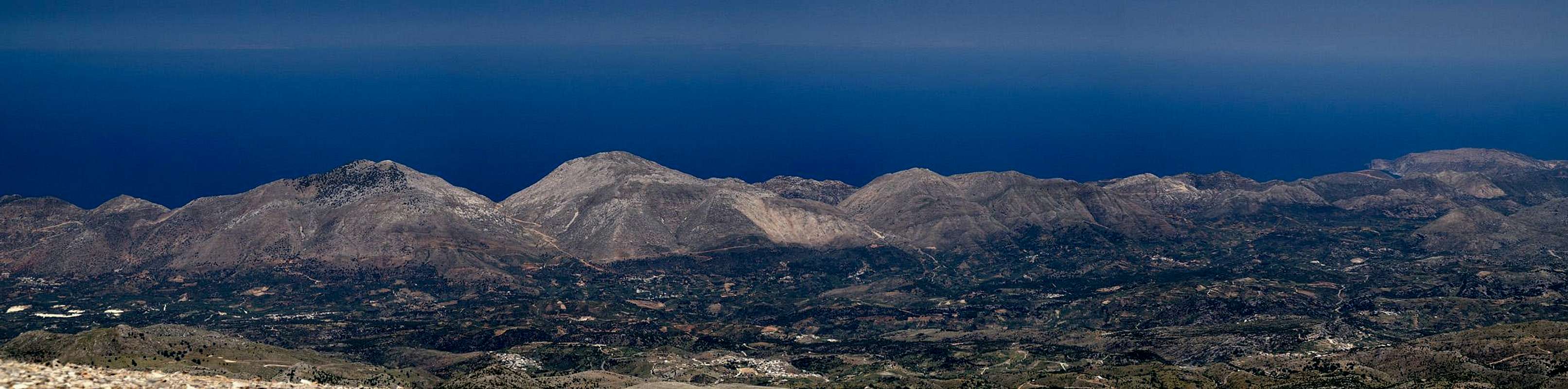
 Geroskinos on the north-west coast of Crete Geroskinos on the north-west coast of Crete |
Crete – Κρητι in Greek - is the fifth largest island of the Mediterranean (after Sicily, Sardinia, Corsica, Cyprus) and – apart from Corsica it is probably the most mountainous one. While only parts of the north coast and the east coast can be called flat, the rest of the island is very rocky. Even the peninsulas like Gramvoussa or Rodoupou reach elevations of about or more than 800m. There are a lot of good hiking possibilites, some great canyoneering but climbing plays only a minor role. The quality of the limestone rock is to blame but you’ll find more on this in the next subsection.
Crete – like Sicily has a very rich cultural heritage. The two islands share the big historical outline: early cultures in ancient Greek times – lots of conquests with long times of foreign domination – upheavals in the 19th century which brought independence – the inclusion in a bigger national framework (here Greece, there Italy). Even today both islands have similar economies with Crete putting a stronger focus on the tourist industry. There is no place of interest on the island, which is not visited by tourists. The tourist hotels can mainly be found in the flat stretches along the north coast of the island, also in its far east. Town Like Sougia or Chora Skafion in the south still have the flair of being undiscovered though a closer look will tell you the truth.
Having said this, you can be amazed that a country with such a long historical record still has virgin areas. Most parts of the Levka Ori and of the Oros Dikti, two of the three highest mountain ranges are as solitary as you can require. However, they are also very hard to reach – which after all is the reason for the loneliness up there. You share the mountains with hoards of goats or with an occasional Golden Eagle or Bearded Vulture and sometimes you might even meet a shepherd or two.
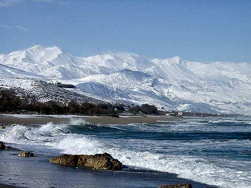
As a visitor to Crete you must keep in mind that you are already very close to the African continent. Consequently the sun burns down vertically from above. Hikes along the coastal areas of the south become almost unbearable. The noon heat should be avoided and in any case don’t forget to bring lots of water. In the mountains be sure to take a compass with you. In the limestone landscape is tough to distinguish landmarks and foggy conditions can become hazardous, especially as caves and crevices abound and gorges can block the way.
1.1 - Mountaineering on Crete
Overall Crete is a very mountainous island. It is home to three tall mountain ranges, all three reaching more than 2000m in elevation. The highest one is Oros Idi / Ορος Ιδη, the Ida mountain range with Crete’s highpoint Psiloritis (2456m). It is located almost directly in the geographical centre of the island. The second highest range is Levka Ori / Λευκα Ορι, the White Mountains of the west of Crete. Its highest mountain is Pachnes, a mere three metres lower than Psiloritis. The White Mountains are the largest of the mountain groups and contain about 60 summits above 2000m. Its name is derived from the white limestone rock as well as from the fact that the range stays snow covered until late in spring. The third of the large ranges is Oros Dikti / Ορος Δικτη in the east of the island. The highest summit is Spathi at 2147m.
Between these large ranges you find several lesser ones, reaching between 1000m and 1600m. Often these small ranges consist of a single ridge, maybe two. They are separated by profound valleys, thus the distinction. Interesting are the almost circular plains, which you can find at the outskirts of the big ranges. They are sedimentary plains, into which over the millennia the material has been washed into from the surrounding mountain crests. The best known plains are the Omalos Plain to the north of the Lefka Ori, the Askifou plain to its east, the Nida Plain east of Psiloritis and the Lasithi plain north of Oros Dikti.
All mountain ranges are made up from limestone and show the features and formations, typical of karst: round-topped summits, caves and crevices, gorges and plains. While none of the mountains is overly difficult (at least on its normal route) going is rough, thanks to the sharp-edged rocks. The central parts of the Levka Ori and the Oros Dikti are very remote and you need a day tour to get into the vicinity. Consequently only the most prominent mountains are climbed on a regular basis and even they can be lonesome most of the time.
1.2 - Canyoneering on Crete
Rather than being known for its mountain ranges Crete can be defined as the island of canyons. Thanks to the limestone karst from which the mountain ranges are made up deep gorges have developed over the millennia. Most of the gorges have vertical walls of profound height while the width of the canyons differs somewhat. The most impressive canyons can be found on the south coast of the island, from where they reach far into the Levka Ori and Dikti mountain ranges. Europe’s longest canyon, the Samaria Gorge heads for 16km into the heart of the Levka Ori, from Agia Roumeli to Xyloskalo.
Quite naturally the gorges differ in difficulty. Quite often the wider ones of them were used to connect mountain villages with the coast or with each other. The Samaria Gorge is one example, the Aradena Gorge is another. Often there are old mule trails, sometimes dating back to Roman time, which now have been maintained into veritable hiking roads. The Kallikrati and Polyrinia Gorges are two examples.
Real canyoneering is also possible – there are numerous canyons, which are more or less inaccessible for the regular hiker. Huge blocks and boulders bar the way and it takes a lot of experience to climb through the more difficult ones. The Diktimos Gorge in the north of Crete is an easy example, the Ha Canyon in the south-east a difficult one. There are many gorges which are never visited, especially the ones in the higher reaches of the three big mountain ranges. All gorges have a lack of water in common. While you might find a creek at the entry point, more often than not the water vanishes somewhere within the canyon.
1.3 - Trekking on Crete
There is one large trekking route on the island of Crete, which is part of the European Long Distance Path E4. The trek starts in the north-west at Kissamos and ends in the far east of the island at Kato Zakros. The route is varying (very much so) in quality: often you have to hike roads (the whole western leg is a walk on asphalt roads, in other places the path is overgrown (the south coast springs to mind) or not marked at all (long passages in the Levka Ori). At Sougia on the south coast it branches into two tracks, one along the coast which is very rough and one through the mountains. The two tracks recombine on the south coast near Frangokastello but immediately branch again into two sections. The following table contains a list of the stages. Please note that the coloured parts contain the respective alternatives.
| Startpoint - Endpoint | Length | Comment |
| Common Western Stages | ||
| Kissamos – Sfinari | 22km | 10km on roads |
| Sfinari – Chrissoskalitissa | 32km | all on roads |
| Chrissoskalitissa - Paleochora | 14.5km | all on roads |
| Paleochora – Sougia | 14.5km | hiking paths |
| Coastal Branch | ||
| Sougia – Agia Roumeli | 20km | rough hiking paths |
| Agia Roumeli – Loutro | 13km | hiking paths |
| Loutro – Frangokastello | 19.5km | 13km on roads |
| Alpine Branch | ||
| Sougia – Omalos | 24.5km | two branches, one through Agia Irini, one through Livadas |
| Omalos – Katziveli | 18km | marked mountain paths |
| Katziveli – Askifou | 20km | much of this part is unmarked |
| Askifou – Frangokastello | 19km | through the Imbros Gorge |
| Northern Branch | ||
| Frangokastello – Kato Rodakino | 14km | most part on roads |
| Kato Rodakino – Agios Konstantinos | 20.5km | mostly hiking paths |
| Agios Konstantinos - Armeni | 15km | hiking paths close to roads |
| Armeni – Arkadi | 29km | field roads and tracks |
| Arkadi – Garazo | 32km | mix of roads and paths |
| Garazo – Anogia | 16km | half of the stage on roads |
| Anogia – Nida Plateau | 22km | half of the stage on roads |
| Alpine Branch | ||
| Frangokastello – Argiroupoli | 27km | half of the stage on roads |
| Argiroupoli – Agouliana | 23km | hiking paths |
| Agouliana – Spili | 13.5km | hiking paths close to roads |
| Spili – Gerakari | 18.5km | mainly hiking paths |
| Gerakari – Fourfouras | 15km | hiking paths close to roads |
| Fourfouras – Toumbotos Prinos Hut | 4km | 1000m elevation gain |
| Toumbotos Prinos Hut – Psiloritis – Nida Plateau | 18km | 1000m elevation gain and loss |
| Common Eastern Stages | ||
| Nida Plateau – Ano Zaros | 25km | second half on roads |
| Nida Plateau – Ano Zaros (alternative) | 19km | sparsely marked footpaths |
| Ano Zaros – Ano Asites | 21.5km | lots of elevation gain (>1000m) |
| Ano Asites – Ano Archanes | 9km | mainly footpaths |
| Ano Archanes – Kastelli | 28.5km | last quarter on roads |
| Kastelli – Agois Georgios | 20.5km | first third on roads |
| Agois Georgios – Alm Selakano | 17km | mountain paths through the Dikti Range |
| Alm Selakano – Prina | 18km | dirt roads |
| Prina – Vassiliki | 19km | mountain roads |
| Vassiliki – Ghryssopigi | 18.5km | footpaths |
| Ghryssopigi – Ziros | 17km | last section on roads |
| Ziros – Kato Zakros | 16.5km | footpaths |
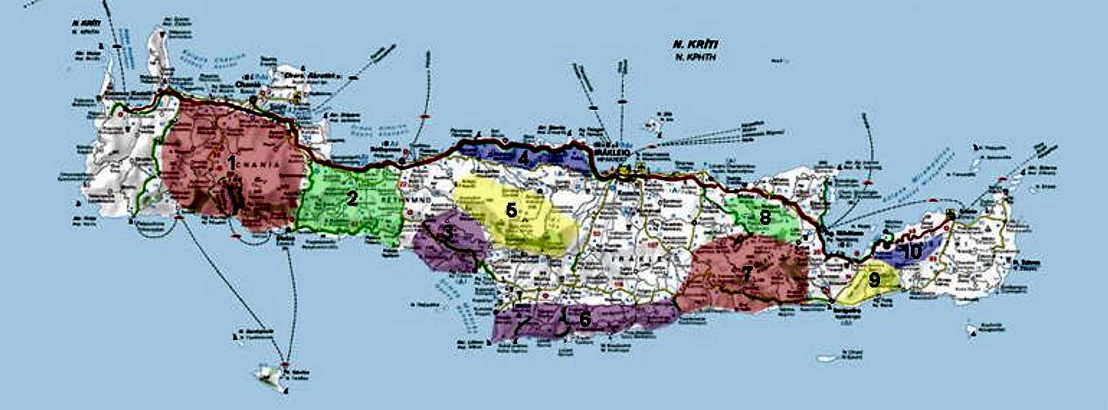
Crete on SP
 |
Together with the map posted above the following list is supposed to give you an overview over the mountains submitted to SP and where you will find them on this page. The map is interactive so that clicking the numbers will direct you to the section on this page. The list below contains mountains and canyons. The canyons are located at the back end of the listing for the respective range.
- Levka Ori / Λευκα Ορη (this page)
Levka Ori / Λευκα Ορη (separate page) - Oros Angathes / Ορος Ανγατηες
- South-Central Highlands
- Oros Kouloukonas / Ορος Κουλουκονας
- Oros Idi / Ορος Ιδη
- Oros Asteroussia / Ορος Αστερουσσια
- Oros Dikti / Ορος Δικτη (this page)
Oros Dikti / Ορος Δικτη (separate page) - Selena Oros / Σελενα Ορος
- Orno Thriptis / Ορνο Θριπτης
- Orno Oros / Ορνο Ορος
3 - Levka Ori / Λευκα Ορη
 |
The Levka Ori are the White Mountains of Crete. Every guidebook will tell you that the name originates in the snowfields, which cover the range deep into late spring. However, another explanation would be the pale limestone of the range, which on any summer day shines brightly beneath the sun. The range is Crete’s second highest one. Pachnes, it highpoint is 2453m tall and thus second only to Psiloritis in the Oros Idi Range, which is 3m higher. The Lefka Ori are the largest of the Cretan ranges with 40 – 60 summits reaching an elevation of more than 2000m. To its south the range rises directly out of the Libyan Sea, to its west and east it is bounded by high plateaus, only on its northern side do you find broader stretches of low country.
Like all the Cretan ranges, the Levka Ori are composed of karst-like limestone. Many profound gorges cut through the range’s southern part, Europe’s largest one, the Samaria Gorge, being the most impressive one. While there are villages all around the range, its central part is barely frequented. Some dirt roads lead into the range but apart from these roads you will only find few paths and trails.
Xyloscalo, the entrance to the Samaria Gorge is an exception. Here several hiking paths lead to the summits to the gorge’s east and west but further onwards the paths vanish. Apart from Xyloskalo there are only few reasonable trailheads, maybe Kambi in the north and Askifou in its west. E4 the European long distance trekking trail as an alpine branch, which leads through the Levka Ori but large parts of it – between the summits of Melindaou and Kastro – are without any markers.
No mountain listing here as I think we may have a range page soon.
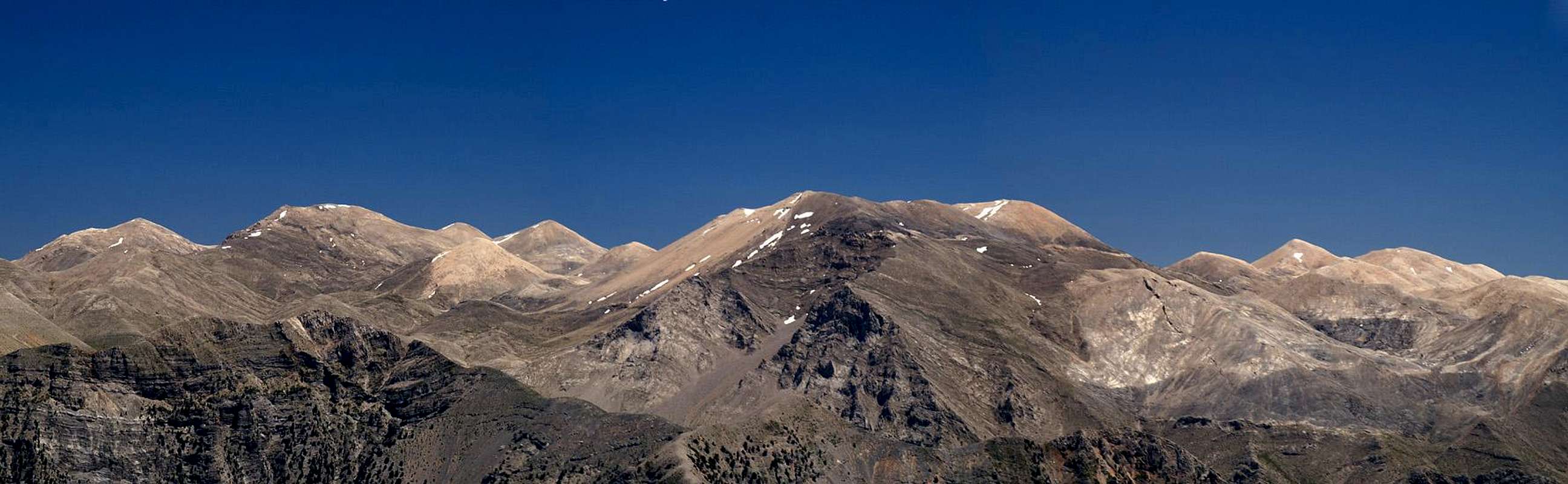
4 - Oros Angathes / Ορος Ανγατηες
 Oros Angathes as seen from Kastro in the Levka Ori
For this lower mountain range I assumed the name of its highest mountain Angathes (1512m). The range can be found to the east of the Levka Ori, beyond the Askifou Plain.There are two subranges, separated by the line Askkifou – Asfendos - Kallikratis - Asigonia. Like in the Levka Ori you find several impressive gorges to the southern side of the range. The Imbros Gorge is the best known one, thanks to its close location to the tourist resort Chora Skafion, but it has less frequented but equally impressive neighbours in the Askifou and Kallikrati Gorges to its east. While the centre of this range also is not inhabited, you find quite a number of mountain villages on its outskirts. The area was one of the retreats of the partisans, which tried to liberate the island from the Turks, and later – during the second World War – from the Germans.
- Northern Subrange
- Halara (1068m)
- Agriokefala (910m)
- Tripali (1493m)
- Amanite (1158m)
- Kato Agori (725m)
- Mega Oros (1181m)
- Kambi (1272m)
- Angathes (1511m)
- Soros (1418m)
- Akones (1239m)
- Agriokefala (1074m)
Southern Subrange
- Kato-Vothones (891m)
- Dafnolakki (836m)
- Perissinaki (1085m)
- Agriokefala (1083m)
- Kentes (828m)
- Atsalokefala ((1043m)
- Spilion Lakki (1051m)
- Kakafes (1258m)
- Krioneritis (1312m)
- Tsilivdikas (929m)
- Xilis Korifi (829m)
5 - South-Central Highlands
 Kedros in the south-central highlands
To the south-west of the Oros Idi Range there are several small ranges, which all are named by their highest summit but most of which consist of several mountains each. The highest mountain of these highlands is Kedros at 1777m.
The ranges with their summit elevations:
- Kouroupa (984, 889m)
- Xiron (904m)
- Apokefala (724m, 739m)
- Assiderato (1162m, 1136m, 1090m)
- Vouvala (947m)
- Soros (1186m)
- Katsonissi (1108m)
- Kedros (1022m, 1368m, 1776m, 1506m, 1127m)
- Samilos (1014m)
6 - Oros Kouloukonas / Ορος Κουλουκονας
 |
Between the coastal cities of Rethymno and Heraklion, between the coastal highway and the land-locked old road there is the ridge of Oros Kouloukonas. It is a barren range with trees only on its lower slopes. The highest of the summits reach elevations of little more than 1000m. In its east the range is divided into two parts by the Fodele Valley, which cuts off the mountains around Vassiliko, which is a military .
- Pahoumis (603m)
- Mavri (882m)
- Kouloukonas (1078m)
- Andrahoukefala (518m)
- Koutsoutroulis (1078m)
- Stefani (848m)
- Mesosfina (644m)
- Voulisma (903m)
- Mavri (560m)
- Aspri (707m)
- Amalotos (642m)
- Alerijay (505m)
- Kato Kefali (526m)
- Vassiliko (734m)
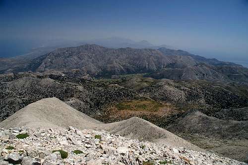
7 - Oros Idi / Ορος Ιδη
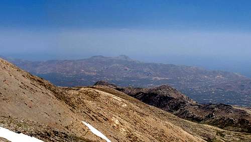
 Oros Idi as seen from the south coast of Crete
Oros Idi, often only named after their highest mountain, Psiloritis, is the second of the large Cretan mountain ranges. Thanks to Psiloritis it is also the highest one, if only by 3m. The range is large buut apart from Psiloritis and the mountains directly surrounding it, most mountains reach elevations of about 1500m only. The range is located almost in the geographical centre of Crete, which makes its mountains excellent lookout peaks. From afar, only Psiloritis stands out (largely) which is why the range often is associated with its name.
The best trailhead for the highest summits of the range is Analipsis (1420m) near the Ideon Andron cave, where Zeus is supposed to have been hidden and raised, right in the centre of Oros Idi. The mountain villages, which surround the range, are at less than 2000m, which makes any climb very long and strenuous. Nevertheless, Anogia in the north, Forfournas in the south-west and Ano Asites in the east can serve as trailheads for the outlying summits of Oros Idi.
The European long distance trekking trail E4 crosses the whole range from east to west. In contrast to the Levka Ori, here the trail is always marked, but the daily stages are long and cover great elevation differences.
Psiloritis has a page on SP which can serve as a range page as well, since none of the other summits are of major importance.
8 - Oros Asteroussia / Ορος Αστερουσσια
 The Asteroussia Range as seen from Psiloritis
The Asteroussia Range is located in the southernmost part of Crete, a long stretched chain of loosely connected mountains. It spreads between the Akrotiri (Cape) Lithino in its west, the southernmost spot of the island, and the town of Tsoutsouros in its east. Several narrow mountain roads lead through the range to villages on the south coast so that there are a lot of possible trailheads. However, most hiking trails run along the south coast and only few head for the mountain summits. Thanks to their location the mountains of the range offer great views along the south-eastern coast of Crete. The highest summit is Kofinas at 1231m.
- Liondaria (467m)
- Vigla (659m)
- Tsouros (593m)
- Vigla (685m)
- Lamnassos (430m)
- Marmaron (900m)
- Kofinas (1231m)
- Maroulia (750m)
- Skiles (736m)
- Asfendilia (979m)
- Limi Viglia (871m)
- Kremasto (969m, 977m)
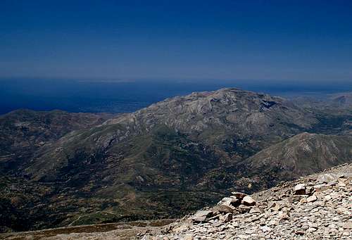
9 - Oros Dikti / Ορος Δικτη
 The Dikti Range above the Lassithi Plateau
The Oros Dikti is the third highest of the Cretan mountain ranges. Located in the east of the island, between Heraklion and Agios Nikolaos, it reaches 2148m in its highest summit, Dikti, after which the range has been named. Like the Levka Ori, Oros Dikti has very remote regions into which only few people venture. It is probably the wildest and most alpinistic mountain range of Crete. The best starting point for the range is the Lasithi Plain (Oropedio Lasithiou), the largest of Crete’s wonderfully circular high plateaus.
Again, the European long distance trekking trail E4 has several stages, which run through the range, marked and in consequence onot too difficult.
For more information about the range see the Dikti Page here on SP.
10 - Selena Oros / Σελενα Ορος
Located to the north of Oros Dikti, just across the Lasithi Plain, the Selena Oros is a small single ridged range, with an elevation of roughly 1500m. To its north there are several solitary summits at somewhat lower elevations. There are not many hiking paths in the range, the most important one is its traverse from Dzermiado on the Lasithi Plain to Vrahasi in the north.- Northern summits
- Pingia (580m)
- Sfakokefalo (536m)
- Kefala Mouhou (630m)
- Fonia Detis (773m)
- Tskoura (998m)
- Arkolakki (915m)
Southern Main Ridge
- Karfi (1400m)
- Selena (1599m)
- Souwlli (1367m)
- Mahera (1487m)
11 - Orno Thriptis / Ορνο Θριπτης
In Crete’s far east, beyond the island’s narrowest part there are two small mountain ranges, located very close to each other. The southern one, Orno Thriptis, is the higher of the two. Its mountains are aligned on a single ridge which runs from south-west to north-east. Its highpoint, Afendis Stavromenos, is the best lookout point in the far east of Crete.- Katalimmata (802m)
- Xulogournes (824m)
- Papoura (1011m)
- Afendis Stavromenos (1446m)
12 - Orno Oros / Ορνο Ορος
The second of the small mountain ranges of the far east of Crete is Orno Oros. Four summits are located on a ridge, which runs from west to east in the northern part of the peninsula. The summits reach slightly more than 1000m but there are no hiking paths in the area.- Kapsas (1002m)
- Spathi (1200m)
- Askordalia (1238m)
- Oros Koprokefala (1179m)
13 - Getting There and Accommodation
13.1 - By Plane
There are two international airports, both in the north of the island. One is at Chania in the west, the other is at Heraklion in the centre. Sitia in the north-east of the island also has an airport, which – to my knowledge – is only a national airport.
13.2 - By Ferry
There are myriads of ferries in Greece, which connect the many islands of the country. Consequently therer are many ferry harbours and Crete is no exception. However, most of the smaller harbours only cater for transportation to the other islands while the major lines to the mainland are reserved to two harbours, Souda near Chania and Heraklion. Both serve connections to Peiraias and Thessaloniki.
13.3 - Accommodation
You can quite easily find hotel rooms and apartments everywhere on the coasts. All European travel companies offer accommodation so a visit to your nearest travel office will find you some. In the mountain villages there always are inns and if everything fails you can pitch a tent.
13.4 - Camping
There are abundant campgrounds along the coast and on many of the beaches you can pitch your tent. The touristic beaches in the north and the beaches in the vicinity of tourist towns are mostly off-limits but there is many a cove which you can use. In the mountains you will often find cattle (goat and sheep) fences which you should respect. There is many a green meadow in one of the plains but you should be aware that you’ll be woken up by goats. Again, in the vicinity of villages, rather ask the locals if you can use their land.
13.5 - Mountian Huts
In the three large mountain ranges you can find several mountain huts, maintained by EOS, the Greek Alpine Club. The ones close to habitation are generally open most times of the year while the remote ones can be closed as late as May.
| Refuge / Hut | Height |
| Lefka Ori | |
| Kallergi Hut | 1600m |
| Volika Hut | 1260m |
| Katsiveli Hut | 1970m |
| Tavri Hut | 1200m |
| Oros Idi | |
| Toumbotos Prinos Hut | 1551m |
| Analipsis Hut | 1420m |
| Prinos Hut | 1100m |
| Oros Dikti | |
| Stanestasi Hut | 1555m |
14 - Red Tape
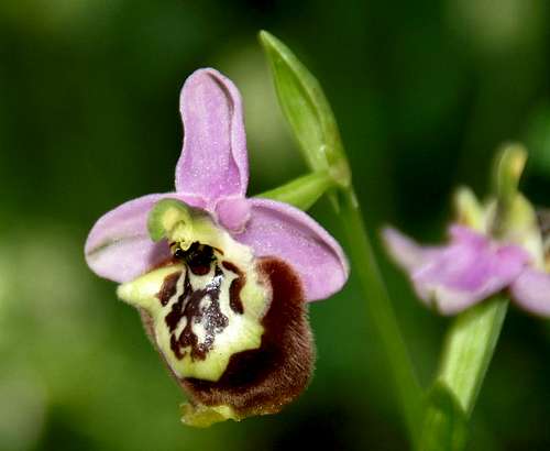 Ophrys episcopalis
There is not much red tape on Crete. There is a National Park which encompasses the Samaria Gorge and its surroundings where over night accommodation is strictly forbidden (even in the huts in the area). You will find that you have to pay entry fees for the most popular locations (again the Samaria Gorge but also the Agia Irini Gorge) but apart from that there are no / few limitations.
On the other hand there are a lot of rare endemic flowers on the island. I'm not aware of any restrictions concerning them but you might take care not to pluck any of them. As for animals, parts of the three large mountain ranges, Levka Ori, Oros Idi, Oros Dikti, are the last refuges for several kinds of bird of Prey: the golden eagle, the bearded vulture and the osprey. Enjoy watching these majestic birds but don't disturb them in their habitat.
15 - Weather Conditions
Crete is already located very close to northern Africa, thus temperatures can get very high. March, April and early May are the best months if you plan to hike the mountains, the winter can be wet, the summer scorchingly hot. Here are a few weatherunderground links to the tourist towns on the island. Be aware that weather in the mountains can be very different from these coastal links. Also, weather changes to the worse can occur in no time. Island mountain weather is very unpredictable16 - Maps & Books
There are quite a number of maps and books out there, which deal with the island of Crete and naturally I don’t know them all. This is the list of maps and books which I used and I appreciate it very much if you can add to it16.1 - Maps
Unfortunately there are no topographic maps of Crete. The best maps I could find are scaled 1:100000 and contain the main hiking routes on the island. In one case the map showed wrong paths and roads (exchanged them) but in general they were quite useful.
- Kreta / Crete / ΚΡΗΤΗ Western Part
Touring Map
1:100000
Harms Verlag
ISBN: 3-927468-16-9
- Kreta / Crete / ΚΡΗΤΗ Eastern Part
Touring Map
1:100000
Harms Verlag
ISBN: 3-927468-17-7
16.2 - Books
Since there are no good topographical maps of Crete you should take care to get a good guidebook. The ones I used have good tour suggestions though the descriptions often are somewhat shortish. In one case the maps were wrong but since the above map also showed wrong paths (as well as other maps I saw later) I attribute this to a general problem with the cartography of this specific area. Moreover, the books were issued in 2002 and thus paths might have changed meanwhile. The books are available in German and English.
- Kreta West / Crete West
Gert Hirner / Jakob Murböck (translation: Gill Round)
Rother Verlag
ISBN:
3-7633-4221-4 (German)
3-7633-4803-9 (English)
- Kreta Ost / Crete East
Gert Hirner / Jakob Murböck (translation: Gill Round)
Rother Verlag
ISBN:
3-7633-4004-1 (German)
3-7633-4822-0 (English)
afariz - Mar 22, 2012 3:03 am - Voted 9/10
mapsThere are only 1:100000 scale maps mentioned but really good hiking maps are disposal recently, even for many years!! Publisher is ANAVASI, for maps is used even partly water-resistant paper and these maps are available - among others - in almost each kiosk or "supermarket" on southern shore under Levka Ori. Three maps cover Levka Ori (area of Sougia-Samaria, area of Pachnes, area of Sfakia), next is covering Psiloritis-Idi Ori and meanwhile last one is Zakros-Vai.
afariz - Mar 22, 2012 3:22 am - Voted 9/10
description of E4 routeThere is one mistake in description of the E4 route, especially of the part from Kalerghi Refuge toward its branching from a dirty shepherd's road up. At a certain distance before this brachning, as described, there should be a "Shepherd's Saddle" and on the same place is a reference to "a summer village of Bouia". Maybe in the name of "Bouia" the letter "r" was omited, however, despite it the more precise is that the saddle itself is called Poria and there is also necessary to say, that at some distance from the saddle down there really are some buildings, but these three buildings can be hardly considered as a summer village, in particular, because they are more work-stations than houses for inhabitation.