
-
 6363 Hits
-
 83.69% Score
-
 17 Votes
|
|
Mountain/Rock |
|---|---|
|
|
49.15886°N / 7.97115°E |
|
|
Sport Climbing, Bouldering, Scrambling |
|
|
Spring, Summer, Fall |
|
|
1283 ft / 391 m |
|
|
Overview
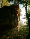
 Southern Leberstein Summit Southern Leberstein Summit |
In the far east of the Südpfalz climbing region you can some of the most impressive standalone crags of the whole area. Trifels and Asselstein are already on SP, Hundsfelsen soon will follow and the subject of this page are the Lebersteine crags. Located in the far south of the Annweiler region, 500m to the north-west of Hundsfelsen, the Lebersteine are two crags on opposite sides of a connecting ridge. Both are located high on a steep, but rounded hilltop in about 200m distance of each other.
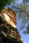
The northern Leberstein is a small, 10m high boulder, distinctly L-shaped, with a very structured surface. The easiest route to the top is a grade 1 scramble to the lower west part of the L, then a bit of handwork to push oneself up to the main eastern part. From its top, the important cliffs of the Annweiler region can be seen: Asselstein, Großer Hahnstein, Kleiner Hahnstein, Anebos.
The main show, however, awaits you when you hike along the ridge to the south and suddenly stand in front of the southern Leberstein. From the ridge it appears to be a boulder like the northern crag, twice as high, with a northern base and a higher southern main summit. However, if you turn west or east to pass the crag on one of its sides, you will realize that the slope of the hill drops steeply southward and that the southern Leberstein from this side reveals itself as a 40m high, slightly leaniing tower with an overhanging structured top. There are half a dozen established routes, all in the 3 - 6 range.
The cliffs are not climbed very often - neighbouring Hundsfelsen is the far more popular crag. Also, there are no paths uphill towards the Lebersteine crags, which poses orientational problems, especially when trying to return to the trailhead near Waldhambach. However, the Lebersteine are surrounded by an old, circular forest road which has intersections with paths in all directions. Note also, that this part of Pfälzerwald has been devastated in the winter storms of 2007 (mainly Cyril) so that many of the paths still are blocked by fallen trees.
|


| Climbing routes on the Lebersteine CliffsThe Lebersteine, as said in the overview section, are two cliffs, located on opposite ends of a ridge. The northern crag is very overgrown, but can be climbed easily. No documented routes exist, though it would be a good bouldering destination. The southern tower has a number of routes of all kinds of difficulties.The following "table" has a link to the tour database of the PK, where you can find the grades for the free routes plus additional information. Here is the link to the complete route database.
Getting ThereThe nearest international airports are Frankfurt/Main and Stuttgart. You can reach Waldhambach, the starting point for the Lebersteine Cliffs, as follows:
|
|


Red Tape
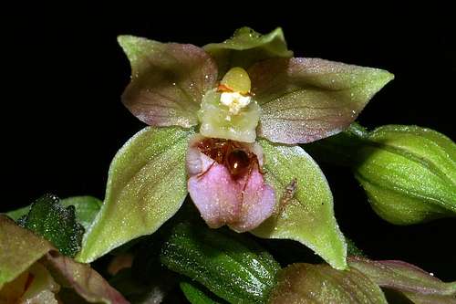 Epipactis helleborine
Like most of the sandstone cliffs of the Südpfalz area the Lebersteine Towers have been declared nature monuments, which saves them from any kind of destruction (like quarrying for sandstone blocks, building houses against them etc). Moreover several general rules apply for climbing the crags:
The sandstone of Südpfalz forms lots of caves and overhangs. Though this makes it most interesting for climbers, two species of birds of prey compete for this habitat: the peregrine falcons and the eagle owls. Both are endangered and wherever there is a eagle owl pair found nesting in the sandstone the crag will immediately be closed. Generally this closure lasts from the beginning of each year through Aug. 1st. If breeding is not successful the closures will be canceled even before that date. For a list of closures see the Closure List of PK.
The use of magnesia is not allowed in the whole Südpfalz region. This is rather a directive or an arrangement than an outright law. Thus you probably will get away with using it but do so only when absolutely necessary. Magnesia closes the pores which you find in the sandstone and together they form a smooth surface which will get very slippery in wet conditions. The rule of thumb is to use magnesia in the highest difficulty sections and only extremely sparingly.
A list of guidelines can be found here (in German).
Accommodation
 Summit view across Waldrohrbach towards Asselstein and Rehberg
There are hotels, apartments, inns and restaurants all over the Südpfalz area. Waldhambach is located to the far east of that region and thus you can take advantage of all the accommodation which is available along the Deutsche Weinstrasse tourist region. The nearest larger towns are Landau to the north-east and Bad Bergzabern to the south-east. There is a site with information about Waldhambach available on the web:
As for camping there is a youth campground to the south of Waldhambach, close to the trailhead for the Lebersteine Crags.
Weather Conditions
The following link is for the village of Waldhambach:Maps and Books
Maps
As for maps there is a good overview map (1:50000) by Kompass Verlag but the best ones are the official topographic maps by the state government of Rheinland Pfalz, scaled 1:50000, 1:25000 and 1:5000. All official maps can be found on the web page of Landesvermessungsamt Rheinland Pfalz
1:50000
- Naturpark Pfälzer Wald
Kompass Map WK766
ISBN: 3-85491-523-3
- Pirmasens Süd
LVA RLP Map L6910
ISBN: 3-89637-193-2
1:25000
Books
Here are a number of climbing guidebooks on the region of Südpfalz. The best one is the one by U. Daigger and H.-J. Cron, complete with many topos. However, it is hard to get by and often out of print almost immediately after a new edition has been published. Currently it is available here.
- Hiking
- Pfälzerwald
B. & J.-Th. Titz
Rother Verlag
ISBN: 3-7633-4268-0 - Klettern im Buntsandstein
U. Daigger, H.-J. Cron
Westpfälzische Verlagsdruckerei St. Ingbert
ISBN: 3-00-015457-4
- Pfalz ++, Klettern im Buntsandstein
R. Burkard, P. Weinrich
Published privately
- Klettern im Naturpark Pfälzerwald
Naturfreunde Lambrecht
Published privately - Pfalz & Nordvogesen en bloc
A. Wenner, Y. Corby, I. Bald
Panico Verlag
ISBN: 3-936740-19-4
Climbing