The page was successfully edited.

|
|
Mountain/Rock |
|---|---|
|
|
44.43310°N / 122.2939°W |
|
|
Trad Climbing, Aid Climbing |
|
|
Summer, Fall |
|
|
3900 ft / 1189 m |
|
|
Overview
 Turkey's Shadow
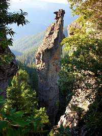
 Dod Route, P1
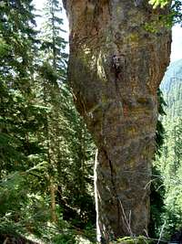 Dod Route, P1
At about 350 feet in height, the Monster is an imposing formation. If it were outside of Moab, it would be a highly sought after desert tower tick. Instead, the Monster sits tucked away deep in the dense woods of the Oregon Cascades invisible to nearly all except for those few willing to bushwhack in. Even when viewed from summits of some other nearby pinnacles (eg. Rabbit Ears), the Monster is flanked by a densely forested hillside making it look like a non-descript rock protrusion. It is only when one reaches the Turkey Point overlook (a rock ridge on the hillside immediately “behind” the pillar) the monstrous nature of the beast becomes apparent: a 250 foot tall cylinder of exfoliating basalt sitting atop a 100 foot tall “stem” (of equally rotten rock) that seems just about half the cylinder’s diameter. The cylinder is topped off with what looks like a dragon’s head complete with protruding flakes that resemble scales or horns. First ascent of the tower was made by a trio of climbers (E. Dod, D. Jensen, and B. Pratt - see External Links section below) in 1966 via the Northeast Face, the route now called the Dod Route. What was originally climbed at 5.6 A3 (with many “giant bongs” per Nicholas Dodge guidebook) has gone free in the 70’s at 5.11- courtesy of local hardmen (Jeff Thomas via a variation to crux pitch and Tom Blust via route proper). Before you jump on it and run up it free (all you 5.11 tigers out there!), beware that you really should be aiming for a no falls ascent, otherwise someone will have to go up there and replace all the mank that you’ll rip for the rest of us aid climbing weaklings.
Notes From FA Climber David Jensen:
I have exchanged a few emails with Dave who was one of three people to make the first ascent of the tower via what is now called Dod's Route. Of the three, Eugene Dod is the guy who first found this tower. His suggestion was to name the tower "Turkey Necked Monster". That idea was defeated by Dave and the present name was thus settled on.
Also, Dave mentions: Can't add much to Turkey Monster--mainly I remember the long approach through thick rhododendron thickets (the logging road hadn't been pushed to where it is now) and prussiking (no jumars then) on the stretchy goldline ropes (you'd prussik a mile it seemed and still be where you started--it was always scary to transfer from a hanging belay to the rope because you'd drop so far if you didn't get all the stretch out). Mainly I remember worrying about how we'd get down. Eugene really wanted it--I thought it too rotten and dangerous.
References
(1) A Climbing Guide to Oregon by Nicholas A. Dodge (ISBN: 0-911518-33-9; out of print).
(2) Western Oregon Rock Climbing, Volume 1: Willamette by Greg Orton (with the Menagerie climbing section being contributed by Jim Anglin; ISBN: 1-879415-43-7). Link to book on amazon.com is here.
Acknowledgements:
I have received helpful route beta from Jim Anglin (Rest In Peace, Jim's done the Dod Route multiple times both as aid and as a free climb) and Tyler (who's done part of this route).
Getting There
 Dod Route, P2
 Dod Route, P3
I will provide written directions to the trailhead for the monster (they are the same as those given on the Rabbit Ears page). The FS roads in the area are a tad confusing for first time visitors. To that end, I highly recommend buying Jim Anglin’s guidebook (here) listed above as Ref. 2 (detailed maps given therein).
From I5 (from west), take exit for US20. Drive US20 eastbound past the town of Sweet Home, Oregon to few hundred feet before mile post 44. Look for Moose Mountain Road on the left (north side). Turn onto it, cross a bridge and veer right onto FS 2027 (dirt). Drive for ~10 miles and look for FS 850 on the right (note that the road is gated shut from January to end of July for nesting raptor protection). Turn onto it and follow it for ~1 mile (it turns into FS856). Keep right at first fork (more like a 90-degree turn) and center at the next (3-way fork). Keep right at the final fork and in 200 feet you’ll dead-end an overlook point with young growth forest.
Hike a climbers’ trail down from the overlook (you should be able to see the tops of the Rabbit Ears) for about 10 minutes until you reach the overgrown forest service road (Menagerie Wilderness bulletin board here). Turn left and follow the overgrown road for about 20 minutes passing a climbers’ camp (fire ring) on the right. Just past the camp, there’s a landslide partially blocking the overgrown road. Turn right and downhill and bushwhack your way a few hundred vertical feet to the Turkey Point Overlook (top of a rock ridge on the forested hillside). Take in the view of the Monster – you’re looking at its north face and the crack before you is the Dod Route. Move left and continue down progressively steeper (and denser) terrain along left side of Turkey Point Buttress. The last 150 feet to the base of Turkey Monster is a treacherous ball-bearing covered and muddy slabs. Fixing a rope might be the way to go.
Red Tape
Area is closed each year for raptor nesting from January till end of July. Please obey these closures! This is a nice site for checking up on nesting closures in western Oregon hills in general.Technically you might need a Northwest Forest Pass at the trailhead but we've never gotten ticketed w/o one.
Camping
 TM from Rabbit Ears
Low profile camping at the trailhead has worked for us - not sure how "legal" it is, but we've never had problems.
If you dislike living on the edge like that, Cascadia Park Campground located on US 20 a few miles west of Moose Mountain Road turn off might be worth checking out.
Routes Overview
 View Up
Reference (1) above provides information on 2 lines: Northeast Face (currently called Dod Route) and Southwest Face. Information on the former is a tad out of date as the route now goes mostly as clean aid (no need for giant bongs, just some cams).
Reference (2) describes the above two routes (excellent information, including topo, given for Dod Route), two route variations and one additional independent line called Wild Turkey. Reference (2) is a highly recommended guidebook if you have any plans to climb The Monster or any other formations in the Menagerie.
Dod Route is (most likely) the easiest line to the summit with the other lines being nail-ups of various levels of desperation (likely).
External Links
There is very little information that I found on the web about climbing the Monster. I have received helpful beta from Jim Anglin's posts on cascadeclimbers.com: here, here, and here.A photo of the Monster from a slightly different angle appears on the tripcheck.com website. The author of the photo is David Jensen of djensenphotography.com. Dave sells high quality prints of this one on his website. Note that Dave is one of three people who did the FA of this tower in 1966. Check out Dave's site for many other outstanding scenery shots -- many are taken from vantage points where only a climber can get to!

NOTE: photo above is displayed as a link - I did NOT submit a photo that is not my own. All copyrights & credit belong to David Jensen.