Horseshoe Mesa and the Grandview
![Topping Out]() Topping out on the Grandview
Topping out on the Grandview is Part 2 or 6 in a continuing story starting with routes East and moving West in the Canyon. Part 1 is the
Escalante Route including information about the Beamer Trail and
Part 3 continues the string with the
Grapevine Loop. Since all three loops sections have the Grandview Trail in common, information about the Grandview is found in all three sections.
Let's Horse Around
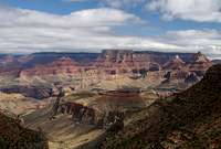
![Smaller Palisades]() West Fork of Horshoe Mesa
West Fork of Horshoe Mesa![Horseshoe Loops]() Combine spurs of the Grandview Trail and the Tonto Trail to make various loops off of Horseshoe Mesa.
Combine spurs of the Grandview Trail and the Tonto Trail to make various loops off of Horseshoe Mesa.
There is another loop (or two) of sorts that can be done between the Escalante Route and the Grapevine Loop. This is anyone of the combinations of several spur trails that extend from the Grandview Trail and circumnavigate Horseshoe Mesa. Let’s talk about the Grandview Trail and Horseshoe Mesa first.
The Grandview Trail is mainly the trail that takes you from the Rim down to Horseshoe Mesa. There are several spurs off of the Grandview that in combination with the Tonto Trail can make for various loop combinations off of Horseshoe Mesa.
The Eastern Spur drops straight down off Horseshoe Mesa to first, take you to Miners Spring for water. Second, this spur takes you to the junction of the Tonto trail where you will either circle under the Mesa or head on to Hance Creek, The River and points beyond.
The Center Spur drops you off the middle canyon face of the Mesa and lands you on the Tonto Trail as it skirts the Mesa.
The Western spur again drops straight off the Mesa taking you to first Cave of the Domes or on to the junction of the Tonto at Cottonwood Creek.
I have never hiked from the point where the middle spur connects with the Tonto on around to Cottonwood on the Tonto. I’ve hiked off the Grandview to points west many times. I’ve hiked east towards Escalante many times. Once while hiking up to the Mesa from Hance Rapids we found the very steep route up the east side of the mesa in such a state of disrepair that we had to swing around the Mesa to the middle spur to gain access to the Mesa. The eastern spur has had a great deal of maintenance sense then and is in wonderful condition as of my last visit in 2006. One of these days I’m going to camp on Horseshoe for two nights just to complete the entire loop around the Mesa.
Setting up camp on Horseshoe Mesa then going down to Miners Spring used to be a tradition in my early years of backpacking back when I had regular partners I backpacked with. The Spring, sometimes called Page Spring (that's not its name) is a delight yet quite a haul back up to the Mesa.
The ascent/descent off the middle spur is considerable more delicate than the plunges off of the Mesa on the East or West spurs and it takes you out to some fabulous vistas but when traveling from A to Z it neither takes you anyplace or leads you away from anyplace that the East or West spurs don’t serve you better. Anyway, if one is headed straight for the Grapevine Loop from Hance then you would either take water from Hance Creek or already have checked with the Backcountry Office to see if there was water in Cottonwood Creek so you might take your water from there. I have never seen Cottonwood dry but I’m told it goes dry regularly.
![Storm Breaks]() Grandview Trail
Grandview Trail
You can clearly see Horseshoe Mesa in the center of this image. The Grandview Trail skirts the Redwall towards the mesa then drops abruptly over the near left face of the Mesa. Cottonwood Creek, the junction of the Grandview west spur and Tonto Trail are clearly visibly in the bottom of the picture. Fine level camps and sometimes water can be found at Cottonwood.
To read more about the Grandview Trail and Horseshoe Mesa see
Escalante Route or the
Grapevine Loop.
The Trailhead
Grand Canyon Village, home of the Backcountry Rangers Office is 60 miles north of Williams Arizona via highway 64 with well marked exit signs along the roadway. The office is 80 miles north of Flagstaff Arizona via highways 180 and 64 but we’ve already obtained our permits so we are not going to the BRO. We are going straight to the trailhead.
The Grandview Trail trailhead is located at the Grandview Point scenic turnout along the South Rim Drive. Travel 12 miles east of Grand Canyon Village on South Rim Drive. Turn north at Grandview Point turnout road and drive to the rim parking lots. The trailhead is at the end of the road.
DO NOT leave valuables in plain sight. Lock them in your trunk.
Lodging
Lodging is much more reasonable in Williams and has more charm than hastling with the mobs on the Rim. Leaving Williams at 4:30 AM puts you at the Grand Canyon South Rim restaurant openings at 6AM and on the trails at 7. Williams has better gift shops and dinner restaurants (restaurants priced within reason anyway) than the rim, sets under a beautiful alpine mountain and is home of the Grand Canyon Railroad.
For lodging information at the Grand Canyon proper, visit the contracted consessionier at
Xanterra Parks & Resorts.
I will add though that a Canyon view suite at the El Tovar is the finest Christams gift I ever received.
Obtaining a Permit
From the Grand Canyon National Park web site
Grand Canyon of the Colorado
Backcountry Information Center
The South Rim Backcountry Information Center is open daily for walk-in visitors from 8 a.m. to 12 noon and 1 p.m. to 5 p.m. Mountain Standard Time. The North Rim Backcountry Information Center is open mid-May to mid-October for walk-in visitors from 8 a.m. to 12 noon and 1 p.m. to 5 p.m. Mountain Standard Time.
Backcountry Information Center staff answer information telephone inquiries at 928-638-7875 between 1 p.m. and 5 p.m. Monday through Friday, except on federal holidays. This telephone number is for information only.
FAX number for permits is 928-638-2125
you can send a fax 24 hours a day, 7 days a week, 365 days a year - HOWEVER the first day of every month we receive many faxes and the number may be busy
Mailing address is:
Grand Canyon National Park
Backcountry Information Center
P.O. Box 129
Grand Canyon AZ, 86023
Backcountry Permit Request Form NOTE: This is a printable form only. You must print the form, fill it out, and then fax/mail it directly to the Backcountry Information Center. Backcountry Permit Form
Backcountry Permit
If you wish to camp anywhere in the park, other than in developed campgrounds on the North Rim, South Rim, or Tuweep, you must obtain a permit from the Backcountry Information Center.
Backcountry travelers must have their permit in their possession while in the backcountry. Once a camp is established, the permit must be attached to a pack, tent, or other equipment in plain view so it can be easily checked by rangers.
Permits are valid only for the trip leader, itinerary, number of people, and dates specified on the permit. Permits for all overnight backcountry use must be obtained through the Backcountry Information Center at Grand Canyon National Park.
Reservations for overnight tent or RV camping in developed Use Areas on the canyon rims (Mather, Desert View, North Rim) are not obtained through the Backcountry Information Center. The Backcountry Information Center does not make reservations for river trips, mule trips, Phantom Ranch lodging, or trips into the canyon on the Havasupai Indian Reservation.
To obtain additional information or reservations for Phantom Ranch lodging, please contact Xanterra Parks and Resorts at 303-297-2757 or 888-297-2757 (www.grandcanyonlodges.com). For hikes into Havasu Canyon contact Havasupai Tourist Enterprises at 928-448-2141 or 928-448-2111 (www.havasupaitribe.com).
Fees
There is a non-refundable fee of $10 per permit plus $5 per person per night camped below the rim and $5 per group per night camped above the rim. Frequent users may wish to purchase a one-year Frequent Hiker membership for $25 that waives the initial $10 fee for each permit obtained by the trip leader for twelve months from the date of purchase.
When sending in a permit request, the preferred method of payment is with a credit card. Please be sure to indicate the maximum amount you authorize the Backcountry Information Center to charge so that your longest trip alternative can be considered. Valid personal checks and money orders against a United States bank are also accepted when made out for the correct amount. Please do not send cash in the mail.
Permit holders will be responsible for paying park entrance fees upon arrival.
South Bass Trail and Pasture Wash Trail visitors may be charged an additional fee by the tribe for crossing the Havasupai Indian Reservation.
How to Apply
Obtain and fill out the Backcountry Permit Request Form:
Permit Request Form
Do not forget to include the following with your permit request:
Trip leader's name, address, and telephone number.
Credit card number, expiration date, signature, date signed, and largest amount you authorize the National Park Service to charge.
Number of people and/or stock in the group (see Private Stock).
License plate numbers of any cars to be left at the trailhead.
Proposed night-by-night itinerary showing use area codes and dates for each night
Organization name if applicable (see Group Size and Commercial Use below).
Alternative proposed itineraries.
Submit the permit request form in one of the following ways:
Most competitive: Bring request in person to the Backcountry Information Center.
Preferred and most competitive written method: Fax request to the Backcountry Information Center, 928-638-2125.
NOTE: You can send a fax 24 hours a day, 7 days a week, 365 days a year - HOWEVER the first day of every month we receive many faxes and the number may be busy.
Mail request to Backcountry Information Center / GCNP, P.O. Box 129, Grand Canyon AZ, 86023.
The Backcountry Information Center treats all requests on a first-come-first-served basis with the following two exceptions:
immediate assistance is given to walk-in visitors, essentially moving them ahead of unprocessed requests
on the first of the month only, four month prior to the proposed start month, all faxed requests received by 5 pm are processed randomly (getting your fax in at midnight on the first does not give you an advantage over another person who sends a fax at 7am).
When to Apply
The earliest you can apply for a permit is the first of the month, four months prior to the proposed start month (see table below). Applying as soon as allowed will improve your chances of obtaining an overnight backcountry use permit for the dates and use areas of your choice.
For dates during the month of: Apply on or after:
January - September 1
February - October 1
March - November 1
April - December 1
May - January 1
June - February 1
July - March 1
August - April 1
September - May 1
October - June 1
November - July 1
December - August 1
Mailed requests must be postmarked no earlier than than the date indicated on the chart. Faxed requests must not be received earlier than the date indicated on the chart.
Permit Responses
All requests are responded to through U.S. Mail - never by fax or e-mail. Due to the volume of requests received, the park cannot confirm receipt of requests until they have been fully processed. Please allow at least three weeks for processing.
When space is available and all fee requirements are met, a permit will be issued and mailed to the trip leader. The permit is valid only for the trip leader named on the permit. Overnight hikers are not permitted to enter the canyon without a valid permit in the trip leader's possession.
If you have been denied a permit through the mail, you may want to consider day hikes or attempt to obtain a last minute, walk-in permit.
Last Minute Permit Availability
People without a permit may be able to obtain one upon their arrival, in person, at the Backcountry Information Center. However, permits are very difficult to obtain during popular seasons.
When demand for campsites exceeds supply, a waiting list procedure is implemented. Participation in this procedure is limited to walk-in visitors only. Obtaining a same-day permit is unlikely; anticipate a 1 to 3 day (or longer) wait.
People may participate in the waiting list for as many consecutive days as are necessary to obtain a permit. However, those on the waiting list must be present at the Backcountry Information Center at 8am Mountain Standard Time each day in order to maintain their position on the waiting list.
The South Rim Backcountry Information Center is open daily for walk-in visitors from 8am-noon and 1-5pm Mountain Standard Time. The North Rim Backcountry Information Center is open mid-May to mid-October for walk-in visitors from 8am-noon and 1-5pm Mountain Standard Time.
Use Areas
Backcountry Use Area Map
The backcountry is divided into "use areas". Each use area has an overnight capacity based upon the size of the area, the number of suitable and available campsites, its ecological sensitivity, its management zoning, and its use history. Use areas range in size from several hundred acres to several thousand acres.
Length of Stay
Camping in the Corridor, Hermit, Monument, Horseshoe Mesa, and Tapeats Use Areas is limited to designated campsites or campgrounds only. Camping in these designated campsites or campgrounds is limited to two nights (consecutive or non-consecutive) per campsite or campground per hike. One exception is made to this rule: from November 15-February 28, up to four nights will be allowed in popular corridor campgrounds.
Outside the use areas named above, "at-large" camping is permitted, meaning that camps are not limited to designated sites.
Trips are limited to a maximum of seven nights per use area; however, overall trip lengths are not limited.
Group Size
More permits are available for small groups (1-6 people) than for large groups (7-11 people). Because there are only a few large group sites, limiting the size of your group will increase your chances of obtaining a permit.
Larger groups tend to cause a disproportionately higher amount of damage to the canyon, largely due to the effects of "social" trailing. For this reason, the park's Backcountry Management Plan does not allow groups larger than eleven people to camp in the same campground or use area.
Regulations stipulate that all permits are void when a group obtains multiple permits for the same campground or use area for the same night. The alternative for these larger groups is to obtain permits for smaller groups and ensure the itineraries for these permits never bring more than one of the permits into the same campground or use area on the same night. No more than four large groups or eight small groups that are affiliated with each other may camp within the backcountry on the same night.
Sister Pages
Sister Pages for trails and routes in this report series are:
Escalante Route
Horseshoe Mesa Combinations
Grapevine Loop
Future Reports in this series will be:
Bright Angel/Kiabab Combinations
Monument Loop
Hermit/Boucher Loop and Points West
A Photo Tour of the North Rim
These pages are coming together quickly. Give me just a couple weeks to complete the initial edits.
Comments
No comments posted yet.