
|
|
Mountain/Rock |
|---|---|
|
|
46.78290°N / 10.90760°E |
|
|
Mountaineering |
|
|
Spring, Summer, Fall, Winter |
|
|
11555 ft / 3522 m |
|
|
Overview
The Mutmalspitze is located in the Austrian state of Tyrol. The mountain is 3522 meters high and is part of the Ötztaler Alps. The mountains is relative unknown and lies to the north of its known neighbours Hintere Schwärze and the Similaun.The normal route is an easy glacier walk. More interesting is the north face, wich offers a short but demanding ice climb.
The first ascent of the Mutmalspitze succeeded already on the 28th of July in 1868 by V. Kaltdorff and his companions.
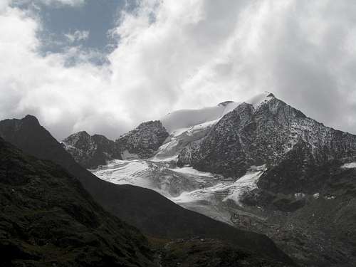 The Mutmalspitze.
Getting There
In general, to the village of Vent:* By public transport: The Ötztalvalley has it's own train station (Ötztal Bahnhof). Take the bus from Ötztal Bahnhof to Vent, which will take about an hour.
* By car: on the A12 from Innsbruck (East) or from Bludenz (West) on the E60 and A12 via Landeck. Turn off at Ötztal. You reach Vent on the road through the Ötztal via Ötz, Sölden and Zwieselstein. In Zwieselstein, you have to turn right to the Venter Tal.
To the Martin-Busch-Hütte (2501 m):
* You reach the hut from Vent in Ötztal in 2 1/2 h. You have only to follow the wide road (without cars). It is marked with the number 923. It is a very beautiful way with a wonderful view through the valley along the river. There is no problem on this road.
In winter and spring: as the way to the hut is strongly exposed to avalanches, it should be done in the evening or early in the morning!
Routes
1.Normal route:The route on the Mutmalspitze is not very demanding. Easy glacier walk over the Marzellferner and then through it's southflank/ridge to the summit.
From the Martin-Busch 3-4h, F/L
2. North face:
Long ascent ending at a short, crevasse-covered ice face.
From the Martin-Busch 4-5h, AD/ZS
Difficulty depending on ice conditions: (can vary between 50-80º!)

Map and Guidebooks
Map:-Alpenvereinskarte Nr. 30/1 ötztaler Alpen/Gurgl, 1:25.000
Guidebooks:
-Walter Klier, Ötztaler Alpen. Alpenvereinsführer. 12th ed. Munich 1995.ISBN 3-7633-1123-8
-Andreas Jentzsch and Axel Jentzsch-Rabl, Firn- und Eisklettern in den Ostalpen, 1th ed. 2004. ISBN 3-9500920-0-5
External Links
Martin-Busch-Hütte (2501 m):-Telephone: +43(0)0664/3043151(hut)
-Internet:Martin-Busch-Hütte
Opened in Summer: End of June until the end of September
Opened in Winter: Beginning of March until middle of May/Pentecost
Bergsteigen.at (north face):
Bergsteigen.at
Weather:
Alpenverein.at
Avalanches:
Alpenverein.at