
-
 6223 Hits
-
 84.18% Score
-
 18 Votes
|
|
Mountain/Rock |
|---|---|
|
|
49.19030°N / 7.98509°E |
|
|
Sport Climbing |
|
|
Spring, Summer, Fall |
|
|
1601 ft / 488 m |
|
|
Overview
 Jungturm south and west faces Jungturm south and west faces |
Among the 300 or more sandstone cliffs in the Südpfalz Area there are about a dozen which are termed "classical" when speaking of climbing in the area. They all have had their first ascension in the heyday of Südpfalz climbing, the late 19th and early 20th centuries, often were named by the first ascensionists and over the years have turned into very popular spots for sports climbers. Routes of all kinds of difficulties have been established, forming veritable webs across the faces of these cliffs. Among the most popular ones are Asselstein, Backelstein, Rödelstein, Luger Friedrich, Geiersteine and Hochstein. Even among these Jungturm, the object of this page, takes a special role.
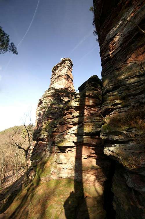
First climbed in 1904 by climbing pioneers Karl and Friedrich Jung and subsequently named after the brothers, Jungturm is the prominent destination on the climbing ridge between the Trifels and Schafenberg Castles. With a height of 27m on its western face, 36m on its eastern one, it is the most prominent crag in the area. In addition, its beautiful south face (see big pic above) has remained on the cover of the best (and only) climbing guidebook about the region, U. Daigger's and H.-J. Corn's "Südpfalz - Klettern im Buntsandstein" (for more info about the book see below).
Jungturm is separated by a narrow gap from neighbouring Münzfels, a gap so narrow that at ground level it rather resembles a chimney. To the north another twin cliff, Bindersbacher Turm and Fensterfels, display a similar affinity to each other; however, they are separated from Jungturm by a gap of about 30m. Climbing on the ridge is heavily dependent on the weather and the season. While in winter only the south and west faces are attractive, in summer climbing activity switches over to the north and east faces. The cliff is located in a pine and beech forest, so that the lower parts of the routes often are overshadowed by tall trees. On hot summer days, when the quite common thunderstorms build up, climbing on the north and east faces can become pretty uncomfortable and dangerous because of moisture condensating on the rock. This way stands and holds become smeary and the routes become vastly more difficult.
|


Climbing Jungturm
 Jungturm north face
Jungturm, along with Trifels, Münzfels and Asselstein is one of the most popular climbing destinations in the Wasgau area. There are no easy routes up the tower, the easiest one being the normal route at IV+, which has been climbed as early as 1904 by Friedrich and Karl Jung, Südpfalz climbing pioneers after which the tower has been named. The following information is linked from the site of the Vereinigung Pfälzer Kletterer I link to their routes database directly with some summary info. Here is the link to the complete database.
For more information see the book by U. Daigger and H.-J. Cron (see below)
| Region | Routes link | Summary |
| Jungturm | Jungturm | 18 routes with variations ranging from 4+ - 10- |
|


Getting There
Jungturm is located south of Annweiler on the ridge which connects Trifels with Schafenberg. The closest parking lot is south of Scharfenberg Castle, right beside the road from Annweiler to Trifels. The closest airports are the ones in Frankfurt and Stuttgart with the following itineraries:From Frankfurt
There are two possible routes which both take equally long- Via Ludwigshafen
- From Frankfurt take motorway A5 southward to Darmstadt.
- There change to A67 south.
- At Viernheimer Dreieck turn onto A6 west.
- Leave it at Frankenthaler Kreuz for A61 south.
- At Mutterstädter Kreuz take A65 south until you reach Landau.
- At Landau turn on B10 west.
- Take the exit Annweiler North after you have passed the second tunnel on the road.
- Take B48 south but after 200m leave to the left, driving into the outskirts of Annweiler.
- After another 300m turn right (sign Trifels) and follow the side road towards the castle. You'll pass Asselstein and Kletterhütte (parking lot), then head on for anothe 1.5km. Where the road turns into a one way road there is a small parking lot.
- Via Kaiserslautern
- From Frankfurt take motorway A3 west
- At Mönchhofdreieck turn onto A67 south
- At Rüsselsheimer Dreieck take A60 west
- At Kreuz Mainz Süd take A63 south
- At Kreuz Kaiserslautern turn onto A6 west
- At Kreuz Landstuhl turn onto A62 south
- At Pirmasens turn onto B10 east
- Take the exit Annweiler North and follow the instructions above (sign Trifels)
From Stuttgart
- Take motorway A8 to Karlsruhe
- At Karlsruher Dreieck turn north onto A5
- Take the next exit to head for A65
- At Landau turn on B10 west.
- Take the exit Annweiler North after you have passed the second tunnel on the road.
- Follow the signs "Trifels" until the road turns into a one way road. Use the parking lot there.
Red Tape
 Jungturm south and east faces
Yes, there is red tape and lots of it. The sandstone of Südpfalz forms lots of caves and overhangs. Though this makes it most interesting for climbers, two species of birds of prey compete for this habitat: the peregrine falcons and the eagle owls. Both are endangered and wherever there is a eagle owl pair found nesting in the sandstone the crag will immediately be closed. Generally this closure lasts from the beginning of each year through Aug. 1st. If breeding is not successful the closures will be cancelled even before that date. For a list of closures see the Closure List of PK.
The use of magnesia is not allowed in the whole Südpfalz region. This is rather a directive or an arrangement than an outright law. Thus you probably will get away with using it but do so only when absolutely necessary. Magnesia closes the pores which you find in the sandstone and together they form a smooth surface which will get very slippery or soapy in wet conditions. The rule of thumb is to use magnesia in the highest difficulty sections and only extremely sparingly.
Fees
There is a parking lot at the base of Trifels which costs € 1.50. Better use the parking lot where the road turns into a one way road, south of Scharfenberg Castle.
Accommodation
There are quite a number of hotels, inns, apartments to be found in the area around Annweiler and Trifels. A good link (German, however) can be found here:Weather Conditions
Maps & Books
Maps
As for maps there is a good overview map (1:50000) by Kompass Verlag but the best ones are the official topographic maps by the state government of Rheinland Pfalz, scaled 1:50000, 1:25000 and 1:5000. All official maps can be found on the web page of Landesvermessungsamt Rheinland Pfalz
1:50000
- Naturpark Pfälzer Wald
Kompass Map WK766
ISBN: 3-85491-523-3
- Annweiler am Trifels
LVA RLP Map L6712
ISBN: 3-89637-191-6
1:25000
- Annweiler am Trifels
LVA RLP Map 6713
ISBN: 3-89637-141-X
Books
There are a number of climbing guidebooks on the region of Südpfalz. The best ones, however, have been published privately and are sold only in selected bookshops of the region.
- Hiking
- Pfälzerwald
B. & J.-Th. Titz
Rother Verlag
ISBN: 3-7633-4268-0 - Klettern im Buntsandstein
U. Daigger, H.-J. Cron
Westpfälzische Verlagsdruckerei St. Ingbert
ISBN: 3-00-0155457-4
- Pfalz ++, Klettern im Buntsandstein
R. Burkard, P. Weinrich
Published privately
- Klettern im Naturpark Pfälzerwald
Naturfreunde Lambrecht
Published privately - Pfalz & Nordvogesen en bloc
A. Wenner, Y. Corby, I. Bald
Panico Verlag
ISBN: 3-936740-19-4
  Climbing Guidebook |
Climbing