
-
 14298 Hits
-
 90.48% Score
-
 32 Votes
|
|
Mountain/Rock |
|---|---|
|
|
28.10552°N / 17.21429°W |
|
|
Spring, Summer, Fall, Winter |
|
|
4104 ft / 1251 m |
|
|
Overview
 Los Roques seen at dawn Los Roques seen at dawn |
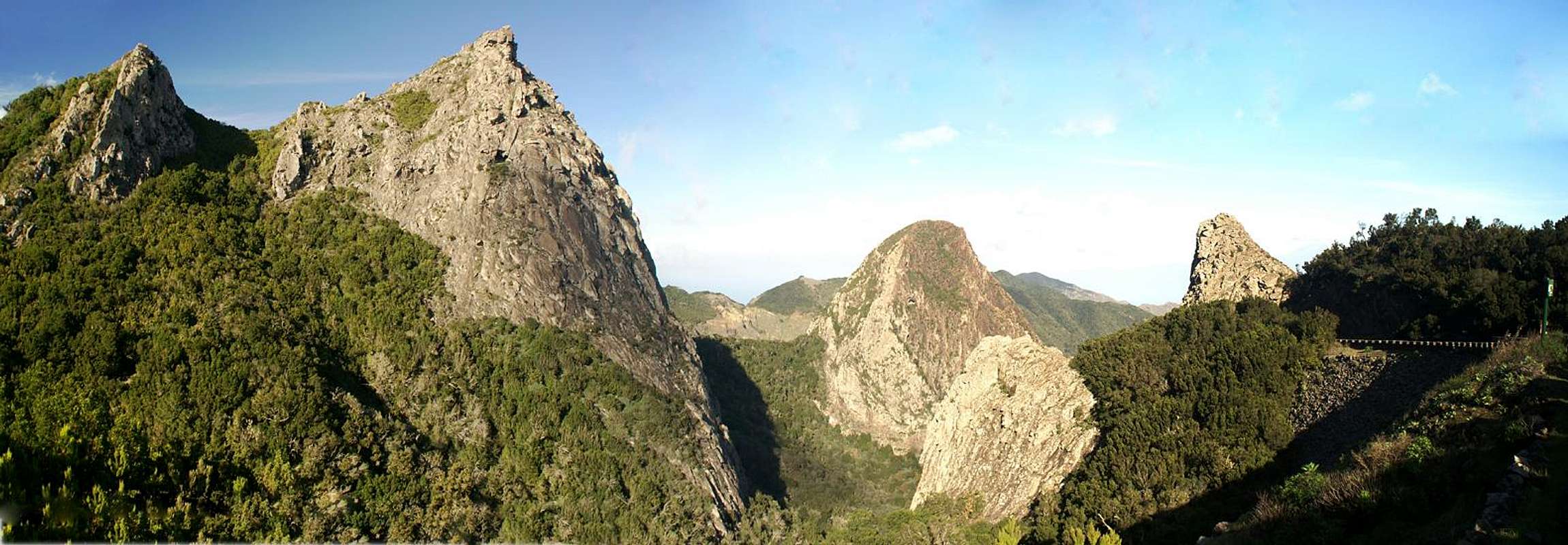
There are several typical rock and erosion structures on the island of La Gomera. Most often you encounter deep and narrow barrancos separated by flat topped mesas. There are also large basalt walls with numerous rock pillars but the most striking feature are rock towers, former volcanic plugs a wonderful selection of which you can find spread out over the whole island.
 |  |  |  |
In the island's centre, very close to its highpoint Garajonay you can find three of the most impressive ones, simply called Los Roques but also known by their separate names Roque de Agando (1251m), Roque de la Zarcita (1223m) and Roque de Ojila (1171m). They stand out above the main road, which connects the east of La Gomera with its west, the Carretera del Centro, a road which every visitor to the island travels at least twice. Thanks to the beautiful backdrop - Teide on Tenerife - the three rocks are the most photographed objects on La Gomera.
 |  |  |  |
Of the three rocks, Roque de Agando is the highest and by far most impressive. It rises for roughly 100m above the Carretera del Centro to its south while the south face reaches 220m. During the 1980s and 1990s there were several climbing routes, mainly on the south face, but since the three rocks have been declared natural monuments climbing is not allowed anymore. The routes were not overly difficult, reaching UIAA IV+ for the most difficult one. On the rock, close to its top, a sanctuary by the prehispanic inhabitants, the Guanches, has been found, proving that rock climbing on La Gomera dates backk to the 16thor 17th century.
 |  |  |  |
Roque de la Zarcita and Roqe de Ojila are located to the north of the carretera. The former is a rather small tower with an imposing east face while the latter is a broad, dome-shaped rock with interesting- looking slabs. However, the two rocks are closed to climbing as well. Not even accessing their bases is possible without breaking the rules of the natural monument.
More Rocks
 The tower of Los Organos rises directly out of the sea
Roque de Agando, Roque de la Zarcita and Roque de Ojila are not the only former volcanic plugs on La Gomera. Close by, to the south you can find Roque de Berruga and Roque de Imada (open to climbing) while in the north of the island there are the twin rocks Los Gemenos in the valley of Hermigua and the big Roque el Cano close to Vallehermoso.
 Roque el Cano above Vallehermoso
Especially the latter rivals Los Roques in stature. All rocks share the same history. All are made up from grey basalt, a much more solid type of rock than the common red basalt you find everywhere else on the island. The towers remained standing while the encompassing lava, tuff and pumice has been washed away to the sea leaving the rocks on the slopes of the mesas which separate the canyon-like barrancos which cut through the island.
 |  |  |  |
A special curiosity is a rock called Los Òrganos, which rises directly out of the sea on the north-western coast of La Gomera. Like the other towers it is a former volcanic plug, made out of grey basalt. Here, however, erosion by the sea has exposed the underlying structure and thousands of pillars rise from the sea. Thus, when seen from the sea, the rock resembles a large organ with several layers of pipes of all sizes.
Getting There
  |
In contrast to the large Canarian Islands, La Gomera and El Hierro don't have international airports. Reaching the islands therefore means switching to a local carrier at Tenerife (or any of the other Canarian islands) or use a ferry. Since weather is known to be unstable at the La Gomeran airport near Playa de Santiago, most travel offices will offer the ferry option.
Usually you will be able to book a flight to Tenerife South together with a bus transfer to the harbour at Los Christianos and the ferry to San Sebastian de La Gomera (bus transfer to your hotel on La Gomera is also included).If you want to travel on your own you can use ferries from either La Palma or Los Christianos and Santa Cruz on Tenerife.
Los Roques can be very easily reached. A road, the Carretera del Centro (TF713) runs by close to the rocks and on a fine day the parking lots will be really crowded and you have to account for busloads of tourists on the lookout points (miradores). Quite often they are shipped from Tenerife for a daytour of neighbouring La Gomera.
 |  |  |  |
While you can't - or rather may not - climb any of the rocks there are a couple of very scenic hiking routes around them. Imho the best one is the one from Pajarito parking lot near to Garajonay which leads to the village of Imada, from there to the hamlet Benjichigua and to Roque de Agando and te Carretera del Norte, a long and strenuous route, but very panoramic.
Red Tape
 Los Roques, eastern view
Los Roques are located just outside the Parque Nacional de Garajonay in a natural monument, Monumento Natural de Los Roques, which has been established to protect the rich natural and historical heritage of the rocks. Climbing is not allowed though up to the 1990s there were routes of UIAA class IV on Roque de Agando. Most visitors remain on the road, TF-713, the Carretera del Centro but if you head out on the hiking trails you are requested not to leave them.
Experience shows that even a World Heritage Site like the Parque Nacional de Garajonay is not safe from us humans. In the 1980s a large patch of the cloud forest burned down due to arsoning. There is a monument close to Roque de Agando commemorating this event and the firefighters who lost their life while battling the flames.
Accommodation
 Los Roques above Barranco de la Laja
Of course you can find a lot of hotels, fincas and casas on the island which you can book from any travel office. There are no close towns or villages, the closest is Igualero to the south-west of the rocks. However, you won't find accommodation there. Rather head for the tourist spots in Valle Gran Rey or Playa de Santiago in the south of the island.
Weather Conditions
 Barranco de Benchijigu
There are few sites on the web, which deal with the weather for La Gomera. The island just is not very popular with the tourist crowd. The ones you can find are for San Sebastian, which is located half an island away to the east of the rocks. Temperatures at the coast are some 15 degrees lower than in the Laurisilva. With fog and high winds this difference can increase a lot.
The following table gives a rough general overview over the weather on La Gomera, at sea level.
| Month | Jan | Feb | Mar | Apr | May | Jun | Jul | Aug | Sep | Oct | Nov | Dec |
| Avg. day temp.[°C / °F] | 20 / 68 | 20 / 68 | 21 / 70 | 22 / 72 | 23 / 73 | 25 / 77 | 27 / 81 | 29 / 84 | 27 / 81 | 25 / 77 | 23 / 73 | 21 / 70 |
| Avg. night temp.[°C / °F] | 15 / 59 | 15 / 59 | 15 / 59 | 16 / 61 | 16 / 61 | 18 / 64 | 20 / 68 | 22 / 72 | 21 / 70 | 20 / 68 | 17 / 63 | 17 / 63 |
| Water temp.[°C / °F] | 19 / 66 | 19 / 66 | 19 / 66 | 19 / 66 | 20 / 68 | 21 / 70 | 22 / 72 | 23 / 73 | 23 / 73 | 22 / 72 | 22 / 72 | 21 / 70 |
| Rainy days | 11 | 8 | 6 | 5 | 2 | 1 | 0 | 1 | 2 | 6 | 8 | 8 |
The Canarian Islands (as well as Madeira) are located in the trade wind zone. You almost always encounter northeastern winds which carry a lot of humid air. Being forced to climb to higher altitudes this moisture condenses into clouds. This in return means that most of the time the northeastern part of the islands is covered in clouds from altitudes of 1000m through 1500m.
The mountainous region in the centre of the island is of the same alltitude and thus stops the clouds. While the northern parts of the islands can be foggy and rainy the southern parts most often are sunny and hot. On La Gomera the centre of the island collects almost all moisture in a big cloud forest, the laurisilva. It is the largest consecutive cloud forest on any of the Canarian islands and has been declared world heritage site.
Maps & Books
Out of the multitude of maps and books I have been using the following. However, so far I have not found a good hiking map of the island. The one posted here is ok but shows only a fraction of the marked hiking trails.- Maps
- La Gomera
Kompass Map WK231
Kompass Verlag
ISBN: 978-3-85491-015-2
Books
- La Gomera
Klaus Wolfsperger / Annette Miehle-Wolfsperger
Rother Verlag
ISBN 3-7633-4007-6 (German)
ISBN 3-7633-4823-9 (English)