
-
 6778 Hits
-
 84.27% Score
-
 18 Votes
|
|
Mountain/Rock |
|---|---|
|
|
49.19091°N / 7.98435°E |
|
|
Sport Climbing |
|
|
Spring, Summer, Fall |
|
|
1394 ft / 425 m |
|
|
Overview
 Fensterfels west face with the chimney to Bindersbacher Turm Fensterfels west face with the chimney to Bindersbacher TurmJumping across the chimney is one of the "regular" routes to Fensterfels |
On the ridge, which separates Trifels Castle from Scharfenberg Castle there are eight standalone sandstone towers which carry varying degrees of importance in the sports climbing worlld of the Südpfalz region. The best known ones are Trifels, Münzfels and Jungturm, located on either side of the ridge. The castle ruin Anebos can be found further north and is mainly popular with hikers and picnicking families while only stray climbers venture into the overhanging east face. Brockel and Kiefernfels are not much more than an afterthought while in the centre of the ridge there is a set of twin towers, which offer good opportunities for all kinds of climbing activities.
Stricly speaking, Fensterfels and Bindersbacher Turm are rather one large cliff. The towers are separated by a narrow chimney only with Bindersbacher Turm - the southern part being by some 3m higher than its counterpart in the north, Fensterfels. Like with all the other crags on the ridge the west faces are exposed to weather so that you can find neat erosion structures there, facilitating the ascent. On the eastern side, however,, you can find overhanging barely structured faces so that here the climbing routes are much more difficult. By a strange twist of nature the west faces are also higher than the eastern ones though the difference is no as pronounced as elsewhere on the ridge.
Thanks to the popularity of the neighbouring rocks both Fensterfels and Bindersbacher Turm are only climbed infrequently. While Jungturm and Münzfels may buzz with activity, our two towers often are overlooked. However, the main hiking path of the area runs through the saddle to the south of Fensterfels so that there certainly is no lack of visitors. There are benches close by and more often than not you can expect to have an audience for your activities.
|


Climbing Routes onto Fensterfels and Bindersbacher Turm
 The overhanging east faces of Fensterfels and Bindersbacher Turm
The two cliffs are not among the most popular climbing destinations in the area. But since Trifels, Anebos, Münzfels and Jungturm are so close, climbers often "spill over" to the two crags. Also, the main hiking path of the area runs through the saddle to the south of Fensterfels so that an audience is ensured. Both towers have easy routes, suited for children but also boulder-like tough problems.
The following information is linked from the site of the Vereinigung Pfälzer Kletterer I link to their routes database directly with some summary info. Here is the link to the complete database.
For more information see the book by U. Daigger and H.-J. Cron (see below)
| Region | Routes link | Summary |
| Fensterfels | Fensterfels | 8 routes with variations ranging from 1 - 8 |
| Bindersbacher Turm | Bindersbacher Turm | 7routes with variations ranging from 2 - 7+ |
Getting There
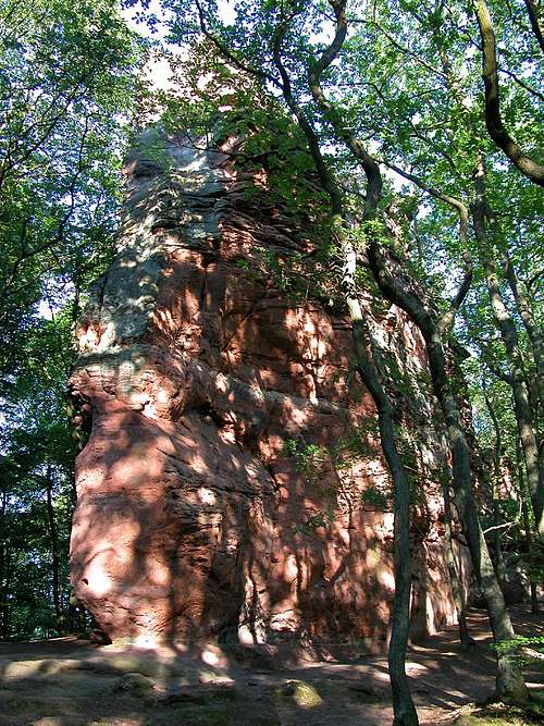 Beautiful interplay of shadow and light on Fensterfels
Fensterfels and Bindersbacher Turm are located south of Annweiler on the ridge which connects Trifels with Schafenberg. Both are located quite central on that ridge close to a saddle through which the main hiking trail of the area leads. The closest parking lot is south of Scharfenberg Castle, right beside the road from Annweiler to Trifels. The closest airports are the ones in Frankfurt and Stuttgart with the following itineraries:
From Frankfurt
There are two possible routes which both take equally long- Via Ludwigshafen
- From Frankfurt take motorway A5 southward to Darmstadt.
- There change to A67 south.
- At Viernheimer Dreieck turn onto A6 west.
- Leave it at Frankenthaler Kreuz for A61 south.
- At Mutterstädter Kreuz take A65 south until you reach Landau.
- At Landau turn on B10 west.
- Take the exit Annweiler North after you have passed the second tunnel on the road.
- Take B48 south but after 200m leave to the left, driving into the outskirts of Annweiler.
- After another 300m turn right (sign Trifels) and follow the side road towards the castle. You'll pass Asselstein and Kletterhütte (parking lot), then head on for anothe 1.5km. Where the road turns into a one way road there is a small parking lot.
- Via Kaiserslautern
- From Frankfurt take motorway A3 west
- At Mönchhofdreieck turn onto A67 south
- At Rüsselsheimer Dreieck take A60 west
- At Kreuz Mainz Süd take A63 south
- At Kreuz Kaiserslautern turn onto A6 west
- At Kreuz Landstuhl turn onto A62 south
- At Pirmasens turn onto B10 east
- Take the exit Annweiler North and follow the instructions above (sign Trifels)
From Stuttgart
- Take motorway A8 to Karlsruhe
- At Karlsruher Dreieck turn north onto A5
- Take the next exit to head for A65
- At Landau turn on B10 west.
- Take the exit Annweiler North after you have passed the second tunnel on the road.
- Follow the signs "Trifels" until the road turns into a one way road. Use the parking lot there.
Red Tape
 Hoverfly (Syrphus ribesii)
Yes, there is red tape and lots of it. The sandstone of Südpfalz forms lots of caves and overhangs. Though this makes it most interesting for climbers, two species of birds of prey compete for this habitat: the peregrine falcons and the eagle owls. Both are endangered and wherever there is a eagle owl pair found nesting in the sandstone the crag will immediately be closed. Generally this closure lasts from the beginning of each year through Aug. 1st. If breeding is not successful the closures will be cancelled even before that date. For a list of closures see the Closure List of PK.
The use of magnesia is not allowed in the whole Südpfalz region. This is rather a directive or an arrangement than an outright law. Thus you probably will get away with using it but do so only when absolutely necessary. Magnesia closes the pores which you find in the sandstone and together they form a smooth surface which will get very slippery or soapy in wet conditions. The rule of thumb is to use magnesia in the highest difficulty sections and only extremely sparingly.
Fees
There is a parking lot at the base of Trifels which costs € 1.50. Better use the parking lot where the road turns into a one way road, south of Scharfenberg Castle.
Accommodation
There are quite a number of hotels, inns, apartments to be found in the area around Annweiler and Trifels. A good link (German, however) can be found here:Weather Conditions
Maps & Books
Maps
As for maps there is a good overview map (1:50000) by Kompass Verlag but the best ones are the official topographic maps by the state government of Rheinland Pfalz, scaled 1:50000, 1:25000 and 1:5000. All official maps can be found on the web page of Landesvermessungsamt Rheinland Pfalz
1:50000
- Naturpark Pfälzer Wald
Kompass Map WK766
ISBN: 3-85491-523-3
- Annweiler am Trifels
LVA RLP Map L6712
ISBN: 3-89637-191-6
1:25000
- Annweiler am Trifels
LVA RLP Map 6713
ISBN: 3-89637-141-X
Books
There are a number of climbing guidebooks on the region of Südpfalz. The best ones, however, have been published privately and are sold only in selected bookshops of the region.
- Hiking
- Pfälzerwald
B. & J.-Th. Titz
Rother Verlag
ISBN: 3-7633-4268-0 - Klettern im Buntsandstein
U. Daigger, H.-J. Cron
Westpfälzische Verlagsdruckerei St. Ingbert
ISBN: 3-00-0155457-4
- Pfalz ++, Klettern im Buntsandstein
R. Burkard, P. Weinrich
Published privately
- Klettern im Naturpark Pfälzerwald
Naturfreunde Lambrecht
Published privately - Pfalz & Nordvogesen en bloc
A. Wenner, Y. Corby, I. Bald
Panico Verlag
ISBN: 3-936740-19-4
  Climbing Guidebook |
Climbing