Synopsis
Aaron, Matt, and I skinned up to
Wheeler Peak (13161') and enjoyed a summit ski descent down its fantastic 2,100' southwest and west-facing slopes to Williams Lake, and then out via the
Williams Lake Trail. This is one of the best and tallest sustained ski lines in the Williams Lake Basin. The roundtrip distance is ~6 miles with a total elevation gain of ~3000'. Our time from the car to the summit of Wheeler Peak was about 3.25 hours, and our total car-to-car time was about 5 hours.
Trailhead information
To get to the hikers' parking area (~10160'), take NM State Route 150 to the Taos Ski Valley parking area. From the NE corner of the parking area, find and take Twining Rd (dirt road) for about 2 miles to the hikers' parking lot which will be on the right side of the road after some switchbacks. This dirt road gets fairly steep, but normal passenger cars will be OK as long as the road is snow/ice free. From the parking lot, follow a well-beaten path heading S from the SW corner of the parking lot. Shortly you will pass the Bavarian Restaurant (good German beers/grub although they are generally closed from early April through late May) and come to the bottom of a ski lift. In early/mid spring, this is generally where you can start skinning. Head up the slope (past the lodge) and turn left at a small shack called Black Diamond Espresso (too bad it's only open when the lifts are running). This is the start of the
Williams Lake Trail.
Climb and summit
We skinned up the trail until just before the sign for
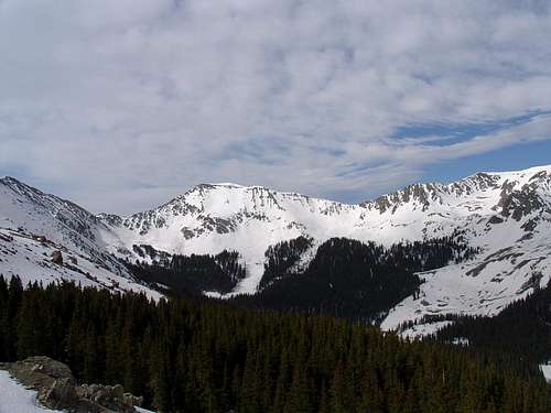
Wheeler Peak Wilderness and then headed up a west-facing avalanche path. We stayed on skis/skins and zig-zagged up through the trees. This part was pretty steep, and I wished I had some tension in my AT bindings so my skis wouldn't flop around so easily as I made kick turns. Aaron and Matt had a much easier time with their tele bindings. After about 1400' vertical or so, we came out of the trees and saw the rest of our route to Wheeler Peak.
![On the way to Wheeler Peak]() Matt & Aaron coming out of the trees.
Matt & Aaron coming out of the trees.![North face of UN 12819]() Looking south to UN 12819.
Looking south to UN 12819.
From here, Wheeler Pk looked a lot closer than it was. We kept skinning for awhile and eventually started bootpacking the final few hundred vertical feet to the saddle between Walter and Wheeler. From here, it was an easy walk to the summit.
![Matt and Old Mike Peak]() Matt on the ridge, with Old Mike Pk in the background.
Matt on the ridge, with Old Mike Pk in the background.![Atomic and Wheeler Peak]() Aaron & Matt on the summit, hamming for Atomic.
Aaron & Matt on the summit, hamming for Atomic.Ski descent
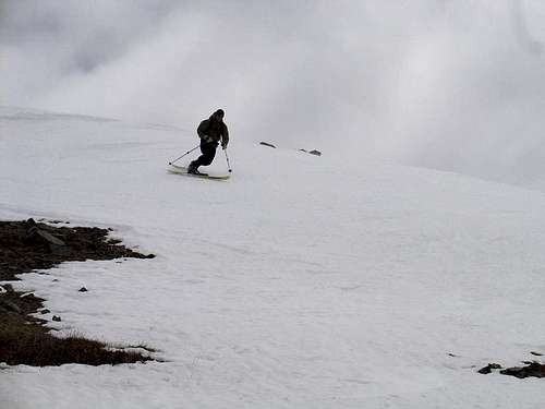
We were able to ski off the summit, linking narrow tongues of snow to a bigger snowfield and then the huge expanse of the west-facing slope down to Williams Lake. There is probably better than 1000 vertical feet of sustained 30 degree skiing before the slope angle decreases toward the bottom.
![Aaron skiing off Wheeler Peak]() Aaron dropping in.
Aaron dropping in.![Looking down the west slope of Wheeler Pk]() Looking down the SW facing slope, with Lake Fork Peak in the background.
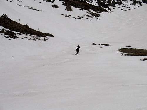
Looking down the SW facing slope, with Lake Fork Peak in the background.![Matt getting low]() Matt getting down.
Matt getting down.![Making turns below Wheeler Pk]() Scott and Aaron making turns.
Scott and Aaron making turns.![Matt skiing through trees]() Matt enjoying the final turns just above Williams Lake.
Matt enjoying the final turns just above Williams Lake.
We skied right down to the eastern edge of Williams Lake (still frozen over and covered by snow), contoured north, and picked up the Williams Lake trail and skied out. Just another great day of backcountry skiing in the Wheeler Peak Wilderness.
Notes
As mentioned above, the West Face on Wheeler Peak holds the tallest sustained ski lines in the Williams Lake Basin. The SW aspect off the summit is a perfect avalanche path. There are many other more aesthetic and intricate ski lines in the Williams Lake Basin, but most of them are of a sustained steepness for only about 600'-1200'. The west face on Wheeler gets windblown and generally doesn't hold much snowpack through the winter months. However, in most years, there's a short window in the spring (mid April to early May) when it's possible to get a continuous ski descent, especially if you head SW off the summit. As always, beacon/shovel/probe and knowledge of their use are essential!
External Links
Northern New Mexico Avalanche Exchange
Comments
No comments posted yet.