
|
|
Mountain/Rock |
|---|---|
|
|
38.65666°N / 106.238°W |
|
|
Chaffee |
|
|
Hiking, Mountaineering, Scrambling |
|
|
Summer |
|
|
13667 ft / 4166 m |
|
|
Overview
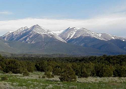
The state gemstone of Colorado is aquamarine. Very near the center of the Colorado lies an overlooked mountain, which is one of the prime sources of gem quality aquamarine in the world. That mountain is Mount White.
Mounts White and Antero
Mount White and Mount Antero are often mentioned in the same sentence by gem collectors and geologists. They are both renowned in the world of gems and minerals, because they produce some of the highest concentrations of crystals and minerals to be found anywhere. Aquamarine, beryl, calcite, fluorite, quartz, and zircon have been extracted from the slopes of Mount White. Other minerals, having longer names that only a geologist can appreciate, are also mined here. Read more.
Mount White is Mount Antero's nearest neighbor, and they have a lot in common. First and foremost, as I already mentioned, is their importance as a source of minerals. These two mountains are connected by a broad 12,850' saddle, and a complex network of roads, all leading to mining digs.
On both mountains, you can drive nearly to the summit. By the way, it doesn't count as "climbing" a mountain if you drive nearly to the summit and walk the rest of the way.
Getting There
Getting to Mount White from the east
From the east, use the Browns Creek Trailhead.
From U.S. 285, find Chaffee County Road 270, 8.8 miles south of the highway junction at Johnson Village. Follow Roads 270 and 272 west for 3.5 miles. Then turn south on 272. Follow the signage 1.5 miles to the Browns Creek Trailhead. These are smooth dirt roads.
To climb Mount White from the west, use the Baldwin Gulch access.
Turn west onto Chaffee County Road 162 from U.S. 285, 6 miles south of Johnson Village. Coming from the south, the turnoff is about 16 miles north of the U.S. 285/U.S. 50 intersection in Poncha Springs. Go west on the County Road 162 (paved) for 12 miles to the Baldwin Gulch Road. With 4WD, you can proceed as far as you please toward Mount White.
Little Browns Creek
View from Little Browns Creek Trail
Little Browns Creek separates Mount White from Mount Antero, and drains both peaks to the east. Given the mineral content involved, I wouldn't drink water out of Little Browns Creek, at any elevation. Would you? Maybe after filtering? After Boiling? I didn't think so.
I found it curious that Little Browns Creek seems to go underground and disappear for long intervals (September 2008). Then further downstream it re-emerges. Little Browns Creek runs parallel to Browns Creek. Little Browns Creek drains the north side of Mount White, whereas Browns Creek drains the south side. The two creeks eventually merge.
FT 1430 follows Little Browns Creek. Trail 1429 follows Browns Creek. There is only one trail at the trailhead. It forks a mile west of the trailhead, where it intersects the Colorado Trail. Don't let the similar names and numbers cause you to take the wrong trail!
Twin Summits
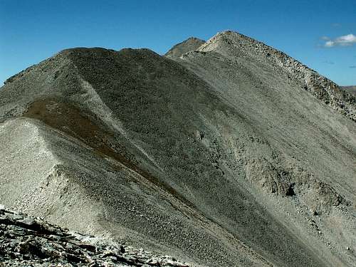
Approaching the twin summits
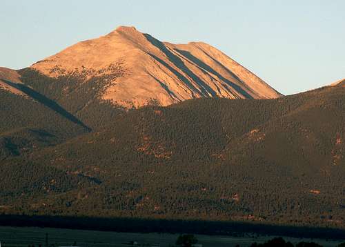
Mount White has two summits that appear equal in height as you approach from the east. The summits are about 300 feet apart. One is white and the other is gray. When I was there, there were cairns on both summits. The east (white) summit is slightly higher, and the unofficial summit register resides there.
Hiking trails are conspicuously missing on the summit ridge. Most people on Mount White come for economic reasons or for four wheeling. Not many come to climb the mountain, as the summit register attests. About 20 persons signed the summit register in 2008.
Red Tape

A New Prospecting Claim
Major red tape: Mount White is practically covered with prospecting claims. You are not allowed to dig on somebody else's claim!
All visitors and users of the National Forests are subject to general Forest Service Regulations. The forest service publishes rules and guidelines on a variety of subjects, including camping, fires, vehicles, and pets.
There are currently no fees required at the main access points to Mount White.
Mountain Conditions / When to Climb
NOAA point forecast
June through September could be considered the normal climbing season for Mount White. Check with the Forest Service office at 719-553-1400, for winter/spring conditions.
You are by no means assured of safe conditions on any day of the year, of course. As always, use good judgment, and check the Weather Forecast before you go. If the weather is threatening, turn around and live to climb another day.
Snowpack Map (Redraw map for current date.)
Camping
Private campgrounds
San Isabel National Forest Campgrounds
No camping or overnight parking is permitted at either trailhead.
External Links
Mt. White on 13ers.com
DU thesis on Mount White management strategies
Colorado Rockhounding info on Mount White
Colorado State Gemstone - Aquamarine