The page was successfully edited.

-
 13261 Hits
-
 77.48% Score
-
 8 Votes
|
|
Route |
|---|---|
|
|
48.45330°N / 113.34343°W |
|
|
Hiking |
|
|
Summer, Fall |
|
|
Most of a day |
|
|
Easy |
|
|
Class 3 |
|
|
Overview
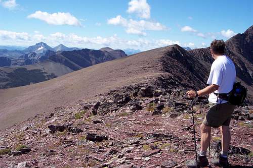 Glacier Park's Scenic Point Ridge Walk
Perhaps the easiest route to the summit of Mount Henry is from the Scenic Point Ridge Walk.
The Scenic Point Ridge Walk is featured in Edwards’ “Routes Among The Peaks” on pages 315-316 in A Climber’s Guide to Glacier National Park. Edwards states in his guidebook that the trip should take about 10 hours. It also crosses unnamed peaks and allows access for other peaks in the area such as Mount Ellsworth on an extended ridge walk.
Mount Henry sits at the head of Appistoki Creek and has an imposing face that rises over 1,700 feet above the valley floor.
Total elevation gained from the trailhead is 3,867 feet to the summit of Mt. Henry. To reach the summit of Appistoki Peak it is necessary descend 1,000 feet in elevation before gaining 500 feet again.
Getting There
 Dancing Lady Mountain from Mount Henry, Fred Spicker photo.
Glacier National Park, the crown of the continent, is located in northwestern Montana and shares a border with Waterton International Peace Park in Canada. The Scenic Point Ridge Walk is located in the Two Medicine Valley in the southeastern corner on Glacier National Park.
See the Mount Henry Main Page for Driving Instructions.
You can also visit the Mount Henry Main Page for information related to Red Tape, Camping, Recommended Equipment and other pertinent information related to visiting Northwestern Montana.
 View of ridge walk from Medicine Peak
Route Description
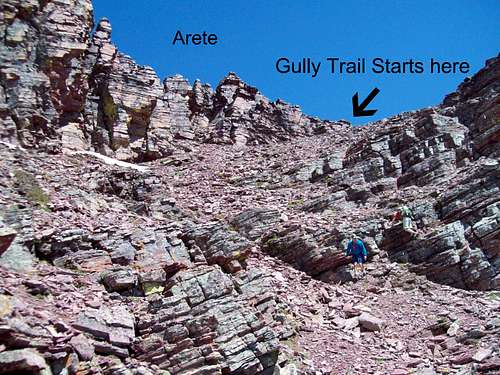 The upper portion of the Gully Route. See photo caption for more details on the route.
Click on the Linked Text to View More Photos of the Route
 Route Topo
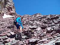 Climbing through the scree in the gully.
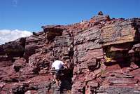 Final pitch to Henry's summit
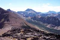 Looking back at descent from unnamed peak to Appistoki saddle
Volume Two of Climb Glacier National Park has details on Mount Henry and suggested routes. It can be ordered at Climb Glacier National Park.
Route Description: From the trailhead enjoy a walk through trees while listening to Appistoki Falls. A short side trip on your return rewards you with a beautiful view of Appistoki Falls. After breaking out of the trees and enjoying Appistoki Creek far below the trail reaches a switchback that yields views of part of Henry’s north face. This is the point that must be reached after descending from Appistoki. Continue on the trail through a series of switchbacks to highest point before reaching Scenic Point. From this location walk along the ridge top to the south to the top of Medicine Peak and continue up the splendid ridgeline until an arête blocks easy access to the summit of Mt. Henry east ridge.
At this blockage there are two options to reach a shelf that transitions to an easy class 3 scramble to the actual summit.
Option 1) Confident climbers can climb along the ridge. See the Scenic Point Ridge Walk - Arete Route for details.
Option 2) Drop down to the left (southwest) and follow the goat trail. After passing below the lowest set of cliffs as seen from the arete continue along the trail to another lower rib of rocks. Once past this lower finger follow the scree filled gully that is easily walked up through loose scree.
Updated Details: June 2010:
It is necessary to walk approximately 300 feet from the actual summit block to reach this gully. A goat trail can be followed for the entire length unless there is snow blocking the route.
This gully is located beyond the lowest cliff finger that can be seen while standing on the platform on Mount Henry's ridge next to the arete (See Photo of platform and arete from Gully Route)
When reaching the bottom of the cliffs seen from the arete continue along the goat trail to the next intervening set of cliffs. This is perhaps another 100 feet beyond the first finger of rocks. From there climb along the shale on the right side of the gully for better footing.
As always be cautious not to loosen rocks if there are others climbing below. The gully makes a dog leg to the right about half way up.
There are a number of options to reach the actual summit from the shelf. None of them have to be more difficult than class 3. At the summit enjoy views into the Nyack area and up to Flinsch and Rising Wolf. The register is located in a white tube on the summit cairn.
Descent From Mount Henry
 Looking to the unnamed peak from Mount Henry
Two Options Present for Descent from Mount Henry. Choose accordingly depending on time remaining for the trip.
Option A: Summit Appistoki Peak
To summit Appistoki continue the route down the west side of Henry on the brilliant red rock that affords good footing. Climbers will stroll along the ridgeline to the unnamed peak that is shaped like a triangle. Summit it if desired or walk around the southwest side to the ridgeline that drops to the Appistoki saddle. An easily followed goat trail makes short work of this incredible descent.
Climbing Appistoki is an easy task as the ridge ascends 500 feet to the summit which sit at 8,143 feet above sea level. Take time and enjoy the views of Two Medicine and the bowl below Mt. Henry’s north face.
Descend from Appistoki to the switchback by choosing one of two options as outlined. Each route will return to the switchback.
Option 1) Descend the east cliffs of Appistoki to the streambed and follow its course along class 3 and 4 cliffs that are easily navigable to the switchback which is at 6,000 feet.
Option 2) Descend 500 feet on the north side of Appistoki to a ramp that slopes east until at the 6,000 feet contour and return to the trail near the switchback. Return to the trailhead via Scenic Point Trail.
Option B: Retrace Route to Scenic Point Trail and return to trailhead.
Needs no further explaination!
Special Considerations
 Mount Henry
The rock in Glacier Park is widely varied and it is not unusual to find several different types of rock on any given route. Know your rocks and be certain of your safety. J. Gordon Edwards has an excellent section in his guidebook on rock and climbing safety. Be safe and know your limitations as well as those who are climbing with you. Also refer to the following links for further details: GNP Rock and Grading System and the GMS Climbing Guidelines.
External Links
Glacier National Park in PicturesGlacier Mountaineering Society
Two Medicine Trails
Visit Montana
Volume Two of Climb Glacier National Park has details on Mount Henry and suggested routes. It can be ordered at Climb Glacier National Park.