
|
|
Mountain/Rock |
|---|---|
|
|
40.21782°N / 5.59746°W |
|
|
Hiking, Mountaineering, Ice Climbing, Scrambling |
|
|
Spring, Summer, Fall, Winter |
|
|
7871 ft / 2399 m |
|
|
Page optimized for a screen resolution of 1280 x 1024 pixels
Overview
 La Covacha seen from SE.
 La Covacha seen from NE.
 La Covacha seen from North.
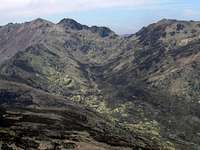
La Covacha is the highest summit of the western massif of Sierra de Gredos, in Sistema Central. Its name can mean “small cave” or “shelter dug in the rock”. Although this area don’t have the alpine nature of Circo de Gredos, crests are rocky and we will use our hands to reach most of the summits. Another feature of this mountain is their relative isolation, which cause long approaches with little elevation gain but that increase the time and hardness of ascents. To be at the farthest edge of Gredos, with regard to Madrid, is another reason for that this mountain is not as visited as other in the Sistema Central, despite its beauty and significance.
La Covacha is a crests junction, with long and deep valleys between them. This valleys are called “gargantas” in Gredos although they aren’t gorges, the literal meaning of “garganta”, but periglacial valleys, with its characteristic wide and flat bottom. Most of these gorges have small lakes in their head, surrounded by high slopes, which always have a special charm. These closed circus are sometimes graphically called “Corrales” (yes, it means corrals) in Gredos. Divides are grassy and gentle but often are topped by granite or, more rarely, quartzite rocks. Grass and bush cover the valleys, where it’s easy to see the ibex (capra pyrenaica victoriae), sometimes sharing the pasture with cows and horses. And really, that is an accurate image to represent this area, where the human presence has been respectful with the environment at the point that human works don’t spoil the landscape but complement it.
 La Covacha sketch.
La Covacha projects three main ridges, where there are several secondary peaks, whose prominences are smaller than 100 ms (300 fts):
* Northeast ridge, which rises after a gap in the needle called Cancho del Losar (Slabs Crag - 2,365 ms), just before Portilla Honda (Deep Pass), that separates La Covacha of the peaks group of Corral del Diablo (Devil’s Circus).
* Southeast ridge, that descent to Portilla de la Mentira (Lie Pass), passing by several needles as Riscos Morenos (Dark Rocks). Beyond the aforementioned pass, stands El Cancho (The Crag).
* West ridge, wich include two secondary peaks, La Azagaya (The Spear) and Ballesteros (Crosbow Men), before dividing itself in two branches:
- To the southwest, it pass by Estecillo and reach Portilla Jaranda, which separates La Covacha group from Cuerda de los Infiernillos (Stove Divide), the westernmost mountain in Gredos that exceeds 2,000 ms.
- To the northwest, the divide reach Castilfrío (Cold Castle), where turns to the north, and continue by Mojón Alto (High Landmark) and Point 2,007, loosing high by Cuerda de los Sillares (Ashlar Divide) toward Puerto de Tornavacas, the pass that separates Gredos from Sierras de Béjar, another mountain area.
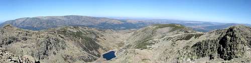 View from La Covacha to the North.
The gargantas between these ridges, define the main routes to reach La Covacha. Two of them, called of Los Caballeros (The Knights) and La Vega (The Lowland), are linear and have a lagoon in its waterhead. The valleys which descent southward, called of Cuartos (Quarters) and Jaranda haven’t a circus but they two are many more branched along its course. The western ones (Serrá, San Martín, etc.) are generally shorter and less interesting than the other.
 View from La Covacha to the South.
Getting There
 Laguna de los Caballeros.
 La Covacha summit.
Depending from which side you want to climb La Covacha, you must first go to one of these villages.
- North: Barco de Ávila, 190 kms away from Madrid, 80 kms from Ávila. There is bus service from Madrid, Ávila, Salamanca and other towns; the company is CEVESA and you can find information about lines and schedulles in the transport page of the website of the Barco de Ávila Town Hall, just as a lot of useful (hotels, tourist services, etc.) or curious (town history, legends, etc.) about this town.
- South: Jarandilla de la Vera, 220 kms away from Madrid. There is bus service from Madrid (La Sepulvedana) and Cáceres (Mirat). In both cases, you can see updated information about prices and schedulles clicking the links.
Both in Barco de Ávila and Jarandilla de la Vera, there are shops, hotels, banks etc. Bases of ascent are always out of towns, sometimes more than 15 kms away, without other option to go on that a taxi or to walk. For that, the most advisable mean to get there is by car. You can see the most convenient route from your point of departure in the Michelin website
Red Tape
 La Covacha seen from the East.
 La Covacha and horses
No one in general, but:
To do fire (in any form) is forbidden during the summer (july to mid-september) in woods.
In the north side, the route of Garganta de la Vega pass through private lands. To pass by foot or even to camp one night or to use the huts is tolerated but owners are not obliged to.
And remember that this is a ranching area: Always shut the gates in the roads after passing.
Camping and Huts
 Corral del Diablo.
There are a lot of places adecuated for camping along the valleys around La Covacha. There is water, ground is grassy and to spend a nigth is allowed.
There are four free huts in the area, without comforts but they are in good conditions and usually relatively clean:
* Paso de Palomas (out of sketch to the north, at 1,500 ms), affordable by car (with care) from Puerto de Umbrías, after 4 ó 5 kms of dirt road.
* Chozo de Anselmo, in Garganta de la Vega at 1,600 ms of altitude.
* Laguna del Barco, in Garganta de la Vega at 1,800 ms of altitude.
* Virgen de las Nieves, in Alto del Guijo, a landing over Garganta Jaranda at 1,500 ms of altitude.
Clicking on the name of the hut, you can see a brief description (in spanish), some photos and a map of every one.
Most Common Routes
The possible climbing routes to this mountain are definited by the crests and valleys that converge in its summit and options are almost infinite. Below, only the most used by local mountaineers are included but there are many more.
 La Covacha seen from the Northwest.
Approach from the North:
- From Navalguijo, by Garganta de los Caballeros. Hiking. Elevation gain 1,200 ms.
- From Navalguijo, by Riscos Morenos. UIAA PD (4th class). Elevation gain 1,200 ms.
- From Puerto Umbrías, by Garganta de la Vega. UIAA F (2nd class). Elevation gain 900 ms.
- From Puerto Umbrías, by the crest from Risco del Águila. UIAA F+ (3rd class). Elevation gain 800 ms.
- From Puerto de Tornavacas, by the crest. UIAA F+ (3rd class). Elevation gain 1,100 ms.
Approach from the South:
- From Guijo de Santa Bárbara, by Garganta Jaranda and Estecillo. UIAA F+ (3rd class). Elevation gain 1,400 ms.
- From Guijo de Santa Bárbara, by South ridge of Estecillo. UIAA F+ (3rd class). Elevation gain 1,400 ms.
The ridge of Losar looks as the most interesting section of crest in the area but I didn’t do it nor find information on its dificulty. I have my opinion but I prefer to say nothing untill do it (soon, I hope).
In winter, ice climbing is possible in the northwest faces of La Covacha and Azagaya. I couldn’t find more accurate information.
When to Climb
 Summit ridge of Losar.
All the year, with the following cares:
- Snow persists usually untill early may and can appear at any time between october and january. A strong snowfall persisting a few days is possible one month before or after that period.
- In summer, it can be very hot and springs are sometimes dryed. Take it in account.
Other Practical Infos
 The ibex, a symbol of Gredos
For local weather forecast, visit the webpage of AEMET (Spanish government weather agency).
Cartography:
Editorial Alpina, sheet "Valle del Jerte", 1:50,000.
IGN, MTN50 series, sheet 576 "Cabezuela del Valle", 1:50,000.