
|
|
Area/Range |
|---|---|
|
|
46.56361°N / 22.70194°E |
|
|
Hiking, Ice Climbing, Canyoneering |
|
|
Spring, Summer, Fall, Winter |
|
|
4777 ft / 1456 m |
|
|
Overview
 Padiş -
  Pádis
PádisEver since I started contributing to SP, I have wished to present the Padiş/Pádis plateau. Initially the lack of photo resources prevented this plan from being fulfilled, nowadays my lack of time does. So, for the moment I will just highlight the most interesting features of this fairytale area.
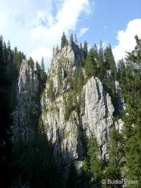
Padiş/Pádis is a karst highland (average height: 1200-1300 m) located in Bihor/Bihar Mountains, on the western edge of the historic Transylvania. These mountains are predominantly covered by dense pinewood forests (although logging has taken its toll on them in some areas), which hide a number of natural beauties, both on and under the surface, offering fine attractions for hikers and cavers, and making Padiş/Pádis a real jewel of Munţii Apuseni / Erdélyi Szigethegység group.
 Poiana Ponor / Ponor-rét
Getting There
Padiş/Pádis plateau can be approached by car from two directions, both leading up to the highland:
- West: via Beiuş/Belényes and Pietroasa/Vasaskőfalva
- East: via Răchitele/Havasrekettye and Ic Ponor/Ponor ék
The upper section of these roads used to be in very bad shape earlier, in recent times their quality has been improved, the road from Pietroasa has even got asphalt cover (I do not know the extent of this, as work was in progress when I visited the place last time). Whether or not such improvements are advisable, decide on your own... for sure some of the tranquility will be gone if admittance isn't regulated (which is actually highly likely).
The area can also be reached by day-long hikes from the south and north:
- South: from Vârtop/Bihar pass
- North: from Stâna de Vale/Biharfüred
 Cheile Someşul Cald Cheile Someşul CaldSzamos-bazár |
 Groapa Ruginoasă Groapa RuginoasăRozsda-szakadék |
 Cascada Evantai Cascada EvantaiEminenciás-vízesés |
Attractions
 Cetăţile Ponorului
Csodavár
 Cheile Galbenei
Galbina-kőköz
 Cetăţile Ponorului
Csodavár
 Cetăţile Ponorului
Csodavár
 Peştera Căput
Hamlet-barlang
 Cetăţile Ponorului
Csodavár
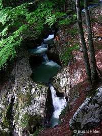
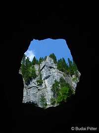
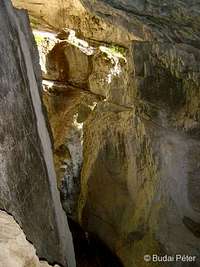
Cetăţile Ponorului (Ponor Castle) / Csodavár (Wonder Castle):
Europe's largest and perhaps most spectacular exokarst phenomenon, consisting of three, approximately 100 m deep cauldrons (dolina 1, 2 and 3) and a 70 m tall Grand Portale, which leads down into a tunnel that interconnects the cauldrons and channels an underground stream towards the Galbena gorge (see below). Part of the tunnel is walkable in dry periods (there is water in it even then), but lights are needed. The inside of the three dolinas can be accessed on the surface as well, by demanding, but safe trails. Another round-trail encircles them on their upper perimeter, from where 4 balconies offer stunning views. The "castle" was discovered accidentally in 1887, by forestry worker Miklós Tóbiás.
External link
Cheile Galbenei / Galbina-kőköz (Galbena gorge):
The beautiful gorge of the "Yellow stream" (Galbena). The start of the gorge is the Galbena spring (Izbucul Galbenei / Galbina vízkelet), which is actually the resurgence of the underground stream coming from Cetăţile Ponorului / Csodavár. Throughout the gorge, this stream has several falls, then gets "swallowed" by the rocks once again only to break out a little further away as the splendid Cascada Evantai / Eminenciás-vízesés waterfall. The trail through the gorge has some difficult sections equipped by steel cables that assist hikers on exposed walls.
External Link
Cheile Someşul Cald / Szamos-bazár (Someş Gorge):
The wild gorge of the Warm Someş/Szamos holds another set of spectacles, including a 212 m long underground stream tunnel (Cetăţile Rădesei / Aragyásza-barlang) with several openings in its roof (hidden inside the forest on the surface), a number of caves, falls and rock towers (ie. the "Sugar cane"). Parts of the gorge are not passable without the risk of falling into the cold (despite the name) and fast-running water, so the tourist trail scales up and down its sides, in a figure-8-shape fashion.
External Link
Poiana Ponor / Ponor-rét (Ponor Glade):
This depression hosts a big meadow, through which a creek flows before getting lost in whirpools. The creek originates in Izbucul Ponor / Ponor-forrás (Ponor spring), located at the foot of one of the surrounding hills. In the wet season, the whirpools cannot drain all the water, and the meadow gets temporarily flooded. The "lost creek" gets tunneled towards Cetăţile Ponorului / Csodavár.
External link
Lumea Pierdută / Elveszett világ (Lost World):
A forested karst plateau first explored in the 1950s by Marcian Bleahu. The area hides an underground cave system, connected with the ground through several deep potholes: Avenul Negru / Fekete-zsomboly (Black hole, 82 m), Avenul Gemănata / Iker-zsomboly (Twin holes, 81 m), Avenul Acoperit / Fedett-zsomboly (Covered hole, 35 m). The "lost underworld" is accessible only for experienced and equipped speleologists.
External Link
Avenul Borţig / Porcika-zsomboly (Borţig Pothole):
A 54 m deep pothole with a 35 m diameter entrance, located above the underground waterway between Cetăţile Ponorului and Galbena gorge. Access to the stream is blocked by some 30 000 m3 of ice, the second largest underground ice mass in Romania (after the Scărişoara ice cave).
External link
Ghetarul Focul Viu / Eszkimó-jégbarlang (Living Fire / Eskimo ice cave):
This cave contains the third largest permanent underground fossil ice block in the country (25 000 m3). The ceiling of the cave is pierced by a large window, through which, at around noon, the sunlight can enter directly, illuminating the groups of ice stalagmites on the opposite side of the cave entrance. The phenomena can be observed well from the wooden balcony at the entrance, which also acts as the boundary across which visitors aren't allowed to go.
External link
Groapa de la Barsa / Bársza-katlan (Barsa Pit):
The Barsa Pit is an oval depression in the Padiş plateau. Its wild and lush forest hosts several interconnected caves: Zăpodie, Neagra / Fekete (Black) caves, Ghetarul de la Barsa / Bársza-jégbarlang (Barsa ice cave).
External link
Cascada Bohodei / Nagy-Phaeton-vízesés (Bohodei Waterfall):
A spectacular fall that plunges about 80 m down a very steep, nearly vertical wall, at the feet of Bohodei Mountain. There is a demanding, occasionally dangerous trail scaling up the wall beside the fall.
External link
Groapa Ruginoasă / Rozsda-szakadék (Rusty Ravine):
A special, 100 m deep, 600 m diameter erosion ravine, with razor-sharp ridges, located not far from Vârtop/Bihar pass (a bit off from the Padiş/Pádis plateau). Its name derives from the reddish-yellowish color of the exposed quartz rocks. In the periods of heavy precipitation, the runoff water from this area escapes through Seaca/Száraz (dry) valley into Galbena/Galbina creek, painting it yellowish (that's where its name comes from).
External link
Accommodation
Up on the plateau there are two options: staying in a hut, or pitching a tent in one of the designated campgrounds. In summer months and early fall expect places to be crowded.
Mountain Huts:
- Cabana Cetăţile Ponorului / Csodavár menedékház (1072 m - 46°33.804'N, 22°42.616'E)
- Cabana Padiş / Pádisi menedékház (1298 m - 46°35.766'N, 22°44.031'E) - a few new buildings are being built next to it
- Cabana Varaşoaia / Vereshegyaljai (Varasó) menedékház (1266 m - 46°36.610'N, 22°42.558'E)
Campgrounds:
- on Poiana Glăvoi / Glavoi-rét (1089 m - 46°34.670'N, 22° 42.240'E)
- by Cabana Padiş
- by Cabana Varaşoaia
On the outskirts of the area, you can find pensions/camping at:
- Boga holiday resort (W, 545 m) - pensions
- Stâna de Vale / Biharfüred spa & ski resort (N, 1102 m) - hotel & campground
- Vârtop / Bihar pass ski resort (S, 1160 m) - hotels & pensions
- Ic Ponor / Ponor Ék (E, 1050 m) - camping & bungalows.
Red Tape
 Izbucul Galbenei
Galbina vízkelet
The area is part of the Apuseni Nature Park. There are no entry fees, but the usual rules apply: keep to the trails (the network of marked trails is dense and well laid out), take your garbage with you, respect nature.
Problems, opportunities, threats:
The "environmental unawareness" of the past few decades has built up serious problems in the field of waste-management (mismanagement), so there is strong need for garbage cleanup in some hotspots (mainly around overused campgrounds). The effect of recent developments in the tourist-infrastructure can be two-sided as well. Some offer a chance of helping reduce the "human footprint" on the area, some may further deteriorate the situation in the absence of effective control measures.
Weather
 Fog is not rare
Munţii Apuseni / Erdélyi Szigethegység are the first mountains that emerge from the Hungarian Great Plain in the east, so the predominantly western winds often get rid of their humidity here. Consequently, these mountains are quite rainy, the annual precipitation exceeds 1000 mm in all areas.
Cold and rainy periods occur even in summertime. The most comfortable season for hiking is late summer - fall (apparently that's the time when the place gets a little crowded as well).
Accuweather stickers for three locations around the Padiş/Pádis plateau:

Snow forecast links:
- Arieşeni / Aranyos
- Stâna de Vale / Biharfüred
Maps
The best paper map I've seen: Dimap, 1:30 000, 3rd edition (2005)
The most useful online map is provided by openmaps.eu (zoom in to see marked trails).
Mountain Rescue
Mountain rescue service is provided by Salvamont Bihor, for details see their website.
Bihar's "Apostle"

The page would not be complete without giving recognition to Gyula Czárán (1847-1906), the great explorer of the Bihar Mountains, who restlessly wandered these mountains and discovered a number of caves and waterfalls at the turn of the 19th century. The mountain people (the area is home to a specific Romanian folk entity, called "moţ") initially regarded this strange-dressed, strange-bearded man walking the forests as an evil elf, but later gradually accepted and helped him, as Czárán became one of their main employers (a generous one) offering them trail constructions jobs as well as posts of tourist guides.
Czárán devoted a lot of his time, energy and great amounts of money to build hiking trails into the wild gorges and other sights of this spectacular area. At the age of 45 he even enrolled himself at the Mining and Forestry University of Selmecbánya (now: Banská Ştiavnica, SK) in order to gain proper knowledge about the use explosives and other techniques of construction works in mountain areas that he could use for his projects. Although a great deal of his work has perished since then, even today tourists use much of what was constructed under his guidance more than a century ago! He also published the first tourist guide about the Bihor Mountains in 1903.
Czárán died on Januray 5th, 1906. At his funeral not only the family and friends were present, but many of the moţ people as well. His gravestone in Moneasa / Menyháza bears the following inscription: "Csak az hal meg, akit elfelejtenek" (Only those die who get forgotten). Czárán Gyula is not forgotten...
- Czárán's tourist guide (1903 edition - in Hungarian)
- Czárán's biography (in Hungarian)
External Links
A bunch of fine photos here.
A short video introduction:
And a more detailed, narrated video, thanks to lukzem: