
|
|
Route |
|---|---|
|
|
35.89451°N / 106.25268°W |
|
|
Hiking, Scrambling |
|
|
Spring, Summer, Fall, Winter |
|
|
Less than two hours |
|
|
easy hiking and rock scrambling |
|
|
I |
|
|
Overview
This is an enjoyable 3-6 mile roundtrip hiking route (with a few spots of easy rock scrambling) along the top of finger-like Otowi Mesa near Los Alamos, New Mexico. The entire route rewards you with spectacular views of the Rio Grande River valley, the eastern Jemez Mountains, and the Sangre de Cristo Mountains stretching from Santa Fe to the Colorado border. The views are especially impressive and colorful around sunset. The entire route lies at an elevation between ~6650' and ~7050'.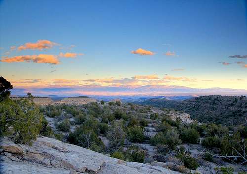
Sunset from Otowi Mesa
Getting There
From the middle of Los Alamos, NM, drive west on Trinity Dr (NM 502). Make a right onto Diamond Dr (landmark: hospital on the corner) and proceed ~2.5 miles to a small traffic circle (shortly after passing a golf course). Take the "9 o'clock" position onto N. San Ildefonso Rd and head up a small hill. This road will bear right twice, becoming Barranca Rd. Stay on Barranca Rd until a few blocks past an elementary school, and make a right onto Los Pueblos and drive it until it ends at a cul-de-sac. Park here. The easy-to-spot trail starts between houses 1895 and 1930. The total driving time from "downtown" Los Alamos is around 10-12 minutes.Route Description
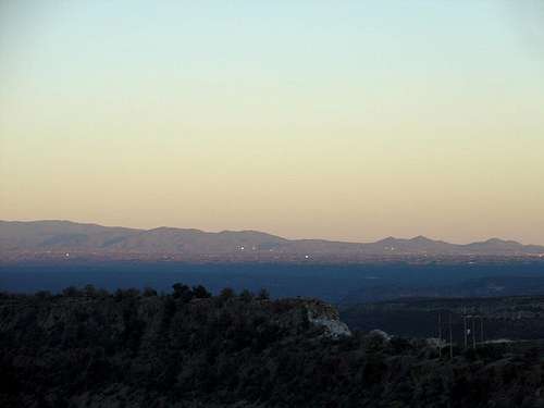
The trail stays on the ridge-top in the foreground and bypasses the rocky step to the left. The mountains above Santa Fe are visible in the distance.
The trail starts from the cul-de-sac on Los Pueblos between houses 1895 and 1930 and quickly descends down a rocky section. From here, angle right (SE) through sparse trees and brush before reaching a narrow rocky section that requires some rock scrambling. There are two different ways to go here, both obvious with steps worn into the soft rock. After this, walk a short distance on rock, climb a small step, and pass below power lines (visible in the photo to the left). You can climb another bigger rocky step (class 3, also visible in the photo to the left) or bypass it to the left. Once on top of this step, the mesa widens a bit for the next ~0.3 miles.
After a total of ~1.0 mile, you will reach a drop-off to a lower bench. This is a natural turnaround point. If you wish to continue, you can head toward the south half of the mesa and descend to the bench below in a couple of places (class 3). From the bench below, go to the south side of the mesa and climb back to the top of the ridge. Continue another ~0.2 miles to a spot overlooking the Otowi Pueblo ruins below (may be hard to spot), for a total of ~1.5 miles from the cul-de-sac. This is the end of the trail as described in Craig Martin's book (see "References and external links" section below). Budget about 2 hours roundtrip for this 3 mile roundtrip hike.
Extra credit
Extra credit (courtesy of SP user saddlebagger): You can continue farther. The mesa eventually forks where there is a cairn (Google maps: 35.886095, -106.232686). Choose the north fork, which starts out pretty flat and broad. By the time you're almost due north of a little white dome (Google maps: 35.883974, -106.224189), there are some impressively sculpted rock formations to pick through. Past that there are some bare tuff hills with trees growing out of nothing. At ~1 mile past the cairn, you will finally get stopped by a cliff band (Google maps: 35.885052, -106.212301). This is around 6650' and ~3 miles from the cul-de-sac. Budget around 3 hours for the full 6 mile roundtrip hike.  Rock formations on Otowi Mesa. Courtesy of SP user saddlebagger. Rock formations on Otowi Mesa. Courtesy of SP user saddlebagger. |  Tree growing out of nothing. Courtesy of SP user saddlebagger. Tree growing out of nothing. Courtesy of SP user saddlebagger. |
Essential Gear
Bring good hiking shoes, proper clothing layers for the season, a camera, and water. A rainshell is desirable in July and August, when short-lived afternoon thunderstorms are frequent.Notes
The first ~0.6 miles of the trail are part of the Los Alamos County trail network before entering land belonging to the San Ildefonso Pueblo. You may wish to call 505-455-2273 to inquire about access issues.Although the mesa is wide enough to avoid the exposed drop-offs, be careful near the edges especially with children. The trail can be hiked all four seasons. However, it may be snow covered after a winter storm. And it is best avoided when wet due to very slick rock on portions of the route.
References and external Links
1. Craig Martin, Los Alamos Trails, 2nd ed. (All Seasons Publishing, Los Alamos, 2006), p. 87.2. Los Alamos area maps
3. Los Alamos County trail network
4. San Ildefonso Pueblo
jniehof - Apr 13, 2010 9:12 am - Hasn't voted
Officially closedListed as closed except the first 0.6mi on County land: http://www.losalamosnm.us/parks/trails/Lists/CurrentTrailClosures/DispForm.aspx?ID=3 San Ildefonso Pueblo land is marked no public access so anyone wishing to take this route would need specific permission.