A Good Start on an Interesting Mountain
To reach Black Mountain I did my normal three hour drive, mostly in the dark and arrived at the trailhead a little after 7 AM. The sun was reaching the deep canyon bottom and it was already warm so a nice day was at hand. One of the many neat things about Black Mountain is the trailhead is the immediate base of the mountain. From where one parks the car, it’s simply across the road, and then the ascent starts. A small trail goes to the top, but this is still one of the steepest summits to hike anywhere. The trail snakes around approximately eight miles to the top with a vertical rise of over a mile. Horizontally the summit sits three miles back from the river.
I have been on the flanks of this big mountain several times poking around the forest. Once for a work project, I even reached to top, though not under my own power. A helicopter dropped two coworkers and I off on top and we did some work on the way down. That drop was a real experience for a number of reasons and through it and some of my other experiences on the mountain, I knew the wonders and dangers to be had on her slopes.
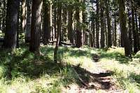
![Northwest Lady Fern (Athyrium filix-femina cyclosorum) - Aquarius Cedar Grove]() Inland rainforest at the foot of Black Mountain
Inland rainforest at the foot of Black Mountain![Lost Pete Creek]() Lost Pete Ck
Lost Pete Ck![Old Growth Mountain Hemlock]() Mountain Hemlock
Mountain Hemlock![East Side of Black Mountain]() Black Mountain
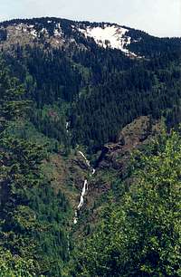
Black Mountain![Black Mountain Waterfalls]() Many waterfalls
Many waterfalls
Black Mountain is in the center of what is known as the Clearwater Refugia; a type of lost world where a remnant maritime forest is allowed to persist thanks to the high precipitation and warm temperatures of the low elevations. Dozens of plant species that normally grow on the west slope of the Cascades along with old growth western red cedar over spectacular fern glades dominate the lower slopes. The drainages that spill down from the heights are very deep and wet; being choked with logs and devils club that make travel in them next to impossible and very dangerous. Some of these streams drop in broken waterfalls for several hundreds, sometimes over a thousand feet. Over the years, I’d been on various parts of the mountain eight times, some of it easy, some of it an ordeal, but always a wonderful experience. It was time to start at the bottom and hike to the top.
The trail is occasionally maintained, but like many in the area it is slowly being reclaimed by the inland maritime rainforest. With the decline of the strong firefighting force that used the paths to man lookouts and put out the fires, there just isn’t the use to keep most trails in the area on the ground. This trail starts on a paved road next to a ranger station and climbs the biggest mountain around, but even with its features and quick access not many people climb it. Perhaps this is because it’s a long and hard haul from the bottom to the top.
The lower elevations ascend through the beautiful lush forest of old cedar, grand fir and some white pine. A little higher up Douglas fir becomes a major component, but in this country that species dies out in 80 – 100 years and that far back is about when the heavy fire suppression started. The result is a forest dominated by this and other species that are at the end of their normal life. Thousands of acres of forest in that area are dead or rapidly dieing, leaving the canopy open, which has allowed the brush to become thick in places. There are occasional spots through this where a hiker has to look closely where the steps are placed to keep them on the small trail and not fall off the steep slope below.
Above this zone, the mountain levels off a little, which allows moisture to congregate enabling the moister species found below to thrive again. At around 5,000 feet this is nearing the top of the elevation limit for this forest type, but it’s a nice break from the steep climb. Soon the trail climbs a little more and actually disappears in the open slopes of an unusual west facing bald, but cutting through the brush up the slope the trail is found after a large switchback that takes the route back around to the south side of the mountain. This area is wet with several large streams coming out of the slope above, which cascade over rocks in a dense alder jungle. The trail gets hard to find occasionally through this wet area and if the trail crews do not keep it up, it will soon be gone. Aspen on these rocky slopes add an unusual forest component for this area.
Maps show the trail entering a long series of steep, tight switchbacks up the face of the mountain just before the alder thickets. The trail does not do this and instead has been rerouted across the south side, through the wet alder area and into a beautiful forest of older Mountain Hemlock. This park like forest consists of dense large tree trunks supporting the thick, dark green drooping foliage that this species is noted for over a floor of even grasses and sedges with some low huckleberry and beargrass. Its an inviting place with a low grade on the both the slope and trail that refreshes a hiker physically and mentally.
The Summit
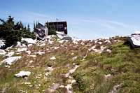
![Black Mountain Lookout]() The lookout
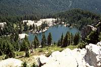
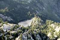
The lookout![Black Lake]() Black Lake
Black Lake
Soon the trail goes through some longer switchbacks to gain elevation and the dense large mountain hemlock is left behind for a much small, more open forest broken up by beautiful heather glades. The trail cut to the west, then turns straight up the slope toward the summit. Larger boulders began popping out and soon I was at the lookout. The mountain to the east and north was much different in character than what I had seen thus far. It was totally open on top of jumbled rocks and to the north large cliffs. Below to the east sat the beautiful blue Black Lake. The views were expansive in every direction, especially to the south into the Selway and Salmon country and the west where I look across the prairies beyond the mountains clear into Washington. The mountains of the St. Joe were to the north and some of the higher Bitterroot points beyond the Montana border were also clearly visible.
This is one of the few lookouts that are still manned and I had a good talk with the woman on duty. She said she only gets about four visitors per year, which was a lot different compared to the previous few years when she worked at Coolwater Ridge on the Selway/Lochsa divide. She was a bit of an odd woman, which I suspect might have something to do with hardly ever seeing other humans. I asked her about a story I heard of about ten years previous where a lookout was heading down the trail for her weekend off and fell breaking her ankle. It was getting dark and she called for help but no one was monitoring the radio. So she was all alone crawling in the dark down the mountain. If that wasn’t bad enough a cougar started stalking her. She threw stuff at it, which seemed to keep it back a bit, but it seemed keyed into her injury and vulnerability and kept moving down the mountain with her. After a very long and intense night she got someone on the radio and the cat finally left.
On to East Sister
![Looking South from the Summit]() East Sister rises more than a mile above the North Fork Clearwater Canyon.
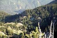
East Sister rises more than a mile above the North Fork Clearwater Canyon.![East Sister]() East Sister
East Sister![Heart Peak]() View north along the way
View north along the way![Nearing the Summit of East Sister]() Summit ridge
Summit ridge
It was decision time. I could return down the mountain now, which would get me home probably about 6 PM or I could continue east to East Sister, Black Mountain’s twin. It was too early to go back so I had to do something more. So I started towards East Sister after first telling the lookout who I was and where I was going just in case something happened they would know where to look. I didn’t leave any word at home about any plans beyond Black Mountain. I returned down the trail a ways, but instead of heading back down, kept going east to the lake where I had my lunch on some high rocks above the east shore. Black Lake is an exceptionally beautiful lake, but there are no good camping places there. While here I noticed a plume of smoke going up to the southeast. This was the Bar Fire, which was being allowed to burn naturally.
Leaving Black Lake I headed east toward East Sister on a trail that got thinner and thinner before it was gone. I spent some time trying to pick it up, but it was no use. No matter, I had a good map and the terrain was simple so I continued on. Soon I was back into the thick old mountain hemlock forest, thankful for the level ground and the shade. To the north there were lovely views of the Mallard Larkins, especially Mallard Peak, Crag Peak, Heart Peak and Larkins Peak. Under the denser trees the trail formed again in the beargrass making travel very pleasant. Soon I was near the point where I would have to leave the trail and start up the long summit ridge that was perpendicular north of the main east-west ridge.
It was a little steep at first, but gradually, the higher I went the more gentle the slope went. Soon the ridge began to narrow, be more open and was studded with larger rocks. These rocks fooled me as to what was the summit a few times, but there was always more and they got larger and more spectacular the further I went. As I neared the top, the last few hundred yards formed a razorback ridge of high contorted formations and jagged boulders. It seemed really strange to see these odd formations composed of granitic and quartzite rocks. Maybe that’s not unusual, but I can’t say I have ever seen it before. The final high point is a long series of rock and I clambered up the spine for a great look around. Especially fantastic was looking back into the giant hole of the North Fork Clearwater Canyon over a mile below. The fire to the southeast was starting to kick up in the afternoon and form a bit of a mushroom cloud. As I took it all in, there was something nagging my mind; what’s my plan?
A Summit Too Far
![Looking East to The Nub]() The Nub from Sister
The Nub from Sister![Subalpine Forest Near the Summit]() Hemlock and Heather
Hemlock and Heather![The Nub High Point]() Nearing The Nub
Nearing The Nub![Snow and Talus]() Hanging Basin
Hanging Basin![East Side of Black Buttes]() Black and East Sister
Black and East Sister
Due to fatigue I was a bit slower making this summit than I had hoped and given my location and the clock, I really needed to think this over closely. To the east was The Nub, an interesting mountain and the third highest in the Mallard Larkin Pioneer Area with multiple glacial lakes on it. To reach it, I would have to drop down nearly 1,200 feet, and then climb nearly 1,100 feet over almost three miles. After that I would have to walk five miles and drop 5,180 feet down to the river road before walking on the road about three miles back to my pick-up. This would make a great loop hike, but I doubted I had neither the time nor the strength to do it. I turned my mind to the path back over Black Mountain. That would take me about nearly eleven miles, almost all of which would be downhill. Bad on my knees, but I could make good time. If I headed east to The Nub, it would be about the same distance, but a good chunk of it would be going up, which in my current state would be a slow process. My head was telling me to go back the way I came, but the wanderlust in me wanted to do the big loop. What to do, what to do? The trail ahead probably would be as spotty as between East Sister and Black Mountain and that would even add more time. Hmmm, if I don’t go to The Nub now, would I ever? One thing I could be certain of was I was loosing valuable time thinking about it. That wouldn’t do and I could solve that particular issue immediately. I launched myself down the hill to the east.
I convinced myself that it would really be fast downhill and I’d just suck it up on the 1,066 foot rise to The Nub, and then it would all be downhill to the bottom of the North Fork. It would be difficult and tight, but I’d just make it work. The big, steep bald on the east aspect of East Sister is quite interesting and it wasn’t long before I found a spot of Ivesia tweedyi. This is a plant that’s disjunct in north central Idaho from the Cascade Mountains of Washington. I had to take pictures, make a collection with field notes. The appropriate State agency would want an observation form filled out and the university herbarium would want a specimen. I should have ignored it given the clock I was dealing with, but the botanist in me couldn’t pass up such a neat find. The stop cost me probably 15 to 20 minutes. I’m hopeless. I dropped a little more and slipped bending my leg out in a manner that I nearly dislocated my hip. That would be a nasty injury, especially very late in the afternoon where no one knew I was. Except the lookout of course and it would be quite some time before anyone looking for me talked to her. I also sliced my hand on a sharp twig and had blood filling the palm and dripping off the fingers. I tightly wrapped my hand in the lower part of my shirt to stop the bleeding and continued on. Soon I reached the bottom and there was no trail where the map said it would be. The decision to go for the gusto was not off to a good start.
As before when the trail was missing, the route was easy to follow. Just cut across the bowl that is the source of the lower Twin Creek and follow the ridge up to The Nub. Soon though I did find a trail and it crossed a very lovely little stream. It must have flowed out of a good spring because I was too high in the basin for this much water to exist otherwise. I really needed to refresh myself before the final uphill push so I took some time, drank a lot and washed myself down with the very cold water. Normally I would have spent a fairly long time at this pleasant place, but I had to get moving.
Soon I came to the place where the trail north to Mallard Peak connected. There was only a bit of a trace left, but I could tell it wasn’t going to last. I did pretty good going across the more level part of the slope, but when the ascent started I slowed to a crawl. My legs were just shot after already climbing nearly 7,300 feet and covering 13 miles to get here. I tried to push it, but mainly wanted to be steady because if I stopped the legs would get really tight and try to knot up. It was a long grueling hike where I had to block out the fatigue and discomfort and go on auto pilot. I just had to put up with the severe stomach ailment I seemed to be developing. Surprisingly my trail up the ridge toward The Nub was well defined, even though it was very small. Being on the ridge the deer and elk probably used it heavily and have thus maintained its existence.
Finally the trail took me to the head of Cliff Creek and I could look across a miniature hanging basin full of very interesting talus. It looked like something quartz-like, but some of it was layered with bent folds. I have never seen this before and would have liked to explore it, but there was just no time. I pushed on around the head of the basin and around to the long summit area.
The Nub
![The Nub, East Side]() The Nub from the east.
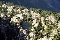
The Nub from the east.![Cliff Lake]() Cliff Lake
Cliff Lake![Steve Lake]() Steve Lake
Steve Lake![The Summit Ridge]() Summit Ridge
Summit Ridge
It was just a very short walk on a nice set of rock stairs someone had formed through the talus to the old lookout site. This structure was very unique in that it had the short remains of stone walls still standing. On the site were many old artifacts that someone had set up on the walls and surrounding flat rocks. A heavy rusty stove and some pans were inside. It looked like someone just walked away one day and left everything. Whoever the lucky lookout was to have worked here had a fantastic view down the North Fork Clearwater canyon to the west and to the south up the same canyon where it made a turn. Straight west the two silhouettes of Black Mountain and East Sister formed massive pyramids. This summit was a fantastic place and I was glad I came. But there was one problem. It wasn’t the high point.
I really needed to get down the mountain. But felt I came this far, I had to do the last little bit to the top. It wasn’t far so hopefully I could be there and back in a few minutes. Well it wasn’t far horizontally, but the ridge was formed by a series of stacked rock pillars that had no easy way to navigate. I started out hiking the sides and crossing over the tops or to the other side when the path ahead closed up. This worked pretty well, but was time consuming. Sometimes there were tangled stunted trees to deal with that could be more time consuming than the rocks at times though they did provide necessary hand holds a few times. Finally I was going up the final northernmost knob, which was the high point. Just as I broke over the rim, a large brownish bird that was perched on a stick poking out of the rocks on the north side exploded into the air. I’m sure he scared me more than I did him. It was a fledgling bald eagle, which is very rare this time of year in these mountains. It was my neat wildlife experience for the day.
I spent only enough time on the top to take some pictures to the north up Skull and Collins creeks and at two beautiful lakes set in the bedrock below on an extensive flat bench that covered several acres. I would like to come back here and camp down there someday, but I couldn’t look any closer this evening. It was time to go and not allow any more delays. Instead of picking my way over the crest back to the trail, I dropped down the east side and cut across an open steep slope. The footing was bad and the sidehill was uncomfortable on my fatigued legs, but it went faster. The last climb of the day to regain the ridge and trail was very short, but took several slow uncomfortable minutes. But I was there and ready to head south on the ridge trail all the way to the bottom. Only 5,180 feet to drop over about five miles and I would be on a level, paved road.
The Big Drop and the Burn
![Looking Southeast from the Summit]() Old burn below The Nub from East Sister. The active Bar Creek Fire in the distance.
Old burn below The Nub from East Sister. The active Bar Creek Fire in the distance.![Northern Nub Lake]() A Nub Lake
A Nub Lake![South End of The Nub Ridge]() Leaving The Nub
Leaving The Nub![Fireweed]() Fireweed in the burn
Fireweed in the burn
The upper ridge was really beautiful. The grade was almost level through open parklands of mountain hemlock in interrupted grasslands and heather patches. The trail was very small, but good. At least for a little while and then it disappeared. No big deal. According to the map the route stayed on the broad, but well defined ridge and I had actually hiked about halfway up from the bottom a few years ago on a good trail so easy times had to be before me. The brush was moderate, but it slowed me a little more than I had time for. Soon I came to a section of trail that had actually been brushed out recently. This was a relief and gave me a boost as I came near a large burned area left from a forest fire in 2003. It was completely stand replacing meaning everything burned. The open forest of charred trees was very bleak over a heavy layer of fireweed and dense new growth brush. When the trail entered this it totally vanished and unfortunately going through the early successional vegetation proved a nightmare. I could hardly move and had no idea where the trail was since the new vigorous growth had totally swallowed it up.
I looked at the map and my altimeter and was concerned that I had not dropped much at all. All I could do was continue to slog on down the broad ridge. Occasionally a trace of a trail would pop up, but never for long. Finally on a narrow part of the ridge the trail formed again just inside the burn boundary, which would stay to the west from here on down. This was a big relief. Now my only concerns were my often problem right knee started being a problem. To compensate I kept my weight on the left leg more. Soon the left knee started to hurt and to compensate for that I started sort of hobble-hop to work my knees as little as possible. This worked, but was taxing my already exhausted body. Soon I couldn’t do it anymore so I just walked normal, which caused my right knee to scream, but I had to endure it.
At last I reached the point where I could look down into the bottom of the canyon. It was close to dark down there and I still had a few hundred feet in elevation to lose. Amazing, as tired as I was, the onset of darkness really motivated me to move faster than I had for some time. The descent became very steep and the trail went into a series of large switchbacks on the open slopes. Though I was on open slopes here, there was just enough light to see my feet and the trail immediately in front of me. Finally I reached the bottom along the edge of the west Twin Creek and now in the forest it was black as coal. I couldn’t see anything except a small faint gray spot up ahead where the trail met the main river road. Only a couple hundred more feet and I would be back to the road, which represented civilization. With a bit of euphoria and relief I stepped out onto the paved surface and immediately turned west towards my vehicle at the Black Mountain trailhead.
In the Dark
![The View Southeast]() The big hole
The big hole
In the open of the wide road corridor there was the slightest hint of light at first, but within 10 minutes all was dark. Fortunately the light road and the white rapids in the river off to the side were less dark that everything else so I could see well enough for the last leg of the journey. My legs felt extremely heavy and didn’t seem to have full range of motion, but it seemed pretty easy to be walking on a completely level surface with nothing in the least to trip me up. The knees even lost most of the discomfort once the slope was lost. All I had to deal with now was the boredom and general exhaustion. The nearly three miles seemed to take much longer than I would have hoped. I fantasized of someone driving by and offering the crazy guy out in the middle of nowhere at night a ride, but the only traffic than went by was heading up river while I was going down. But I finally did make it to the trailhead, opened the truck door and crawled in. I was beyond exhaustion, but very pleased with the realization that I had just hiked 22 miles in 15 hours, most of it on steep slopes.
Euphoria and Big Trouble
![The View North]() Mallard Peak from Black Mountain
Mallard Peak from Black Mountain
I sat of the soft seat thinking it was the most beautiful feeling on earth. I could have went right to sleep, but was too happy. After a few minutes of joyous delirium, I realized I was in big trouble. I had a three hour ride home and it was after 10 PM. I told the boss I would be back around 9 PM. I needed a phone fast. There were few options, but I thought I might find one at the Canyon Ranger Station, which was right at the trailhead. I drove around looking for a phone box in my headlights, but found none. The next option was at Headquarters, an all but abandoned logging town set up by the larger local timber company. I knew exactly where a phone was there, but it would take more than half an hour to reach it. All I could do was drive as fast as possible and hope not to hit any of the deer, elk or moose that were abundant in the area.
Reaching Headquarters I found the phone had been removed. The place was nearly a ghost town now so evidently they didn’t feel the phone was needed anymore. The next tiny town was Cardiff, but no phone there either. I couldn’t believe I was going to have to drive all the way to Weippe to find a phone. It seems there should have been a phone there, but I couldn’t find one and the town was all closed up since it was nearly midnight. Oh well, on to Kamiah where I definitely would find a phone. I arrived in Kamiah at approximately 1 AM. Normally I would have been home by now, but I was driving very slowly because my senses where muted and there were a lot of animals on the road; the last thing I needed was a collision at this point.
Finding a pay phone at a Kamiah convenience store I dialed home and wondered what excuse I would come up with. Predictably I was in big trouble. All I could do was apologize and say I made some errors in judgment and express how hard I was hurting hoping for a little sympathy. I got little as she was upset about having to call the police to look for a missing hiker. The cops frustrated her by telling her that Black Mountain was way up north by Canada and there was no such mountain next to Canyon Work Center. What an idiot, the trailhead is across the road from the station and it’s the biggest mountain for miles and miles in every direction. The mountain far up north is a five hour drive and isn’t nearly as significant of a peak as this one in their back yard.
Refuel and Crawl Home
I got off the phone relieved that I only dealt with a chewing out rather than a full blown conniption and headed into the store to get something to eat and drink. It had been a few hours since I drank anything and I had no food since lunch nearly 13 hours earlier. I was seriously out of fuel and that had to be partly responsible for my sad state. I gathered up some junkfood, ice cream and a soda and hobbled toward the checkout counter. I must have been quite a sight as my cloths were filthy with dirt and soot from the burn area and rigid from dried sweat. I had become very stiff and could only take about half steps and my voice was so strained the woman had a hard time understanding me. This was probably tied for the worse I had ever done to myself up to this point. Much relieved at having something to replenish myself and having cleared the hurdle with home, I climbed into the truck and made the last hour of the drive home.
Black Mountain is a significant mountain to me for several reasons and I felt great satisfaction at finally marking it off my wish list. Though its only a little over 7,000 feet, it has the highest vertical rise of any ascent I had made so far. Though I could hardly walk upon arrival home, I entered the door somewhat triumphantly and my ever supporting wife had recovered sufficiently from her anger to laugh at me as she often does when I crawl in. It was 2 AM and having been awake for 22 hours, and I don’t remember taking a shower or going to bed.
Total Ascent: 7,263 ft.
Total Miles: 22
Time: 15 hours
![Black Lake]() Black Lake
Black Lake


Comments
Post a Comment