
-
 15658 Hits
-
 88.19% Score
-
 26 Votes
|
|
Mountain/Rock |
|---|---|
|
|
44.50990°N / 109.3901°W |
|
|
Park |
|
|
Hiking, Scrambling |
|
|
Spring, Summer, Fall, Winter |
|
|
7606 ft / 2318 m |
|
|
Overview
 Four Bear Mountain
Four Bear Mountain is a peak that is easy to miss; having traveled the road from Cody, Wyoming to Yellowstone Park numerous times, I must admit that I had never even noticed that there was a mountain in this spot because my gaze was always drawn away north to the big peaks in the North Absaroka Range. The only things on this peak that really elicit more than a passing glance from the highway are a few odd-looking rock spires on the southern slopes, but other than that, the mountain itself is very unassuming from far away, consisting of darker rock that is mostly devoid of trees.
However, if you take the time to visit this area and hike The Four Bear Trail, you will never forget the experience. In the space of less than 5.0 miles, this trail passes through a constantly changing and bewildering array of landscapes that include badlands areas, flat prairies covered in sage brush, lush and green creek beds, alien rock formations, wildflowers galore, and forests. This is one of the few places on the planet where rattlesnakes and grizzlies coexist, so this adds a little excitement to the journey as well. Finally, the view upon reaching the summit is spectacular, with dozens of beautiful peaks to capture your attention.
Four Bear Mountain lies at the extreme southwestern end of the North Absarokas, and is mostly made up of the same type of conglomerate rock that can be seen lining the northern side of the North Fork of the Shoshone River all of the way to Yellowstone Park. Many other types of rock can also be found here as they jut out in randomly exposed places, including the round, reddish rocks in this picture.
 Summit view north to Trout Peak
Getting There and Climbing Information
 Rock Formation
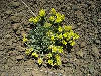 Wildflowers
Take Highway 16 west out of Cody towards Shoshone Canyon, which leads through three tunnels in the canyon and follows the north shore of Buffalo Bill Reservoir. Start marking miles just outside of Cody where the speed limit increases to 55 and travel for 14.9 miles, where you will see a sign on the right for the Four Bear Trailhead. After turning right, you will quickly reach a large parking area with an outhouse and an information sign for the trail. The Four Bear Trail does not yet appear on any topographic maps because it was built by the BLM in 1995 as a way to access the public land in this area, which is becoming harder and harder to reach due to private property.
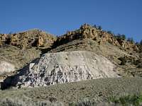 Badlands Formation
 Near the creek
Near the beginning of the trail, there is a small canal to cross; it looks deep, but it is no more than 12 or 18 inches. It is also possible to skirt to the right and go around by crossing over it on a driveway. The trail follows on the left side of a fence before reaching the first gate, where the Jim Mountain trail heads left and the Four Bear trail goes right. Here the scenery gradually changes from an environment consisting of predominantly sage brush to a greener area with trees and shrubs along a creek. After winding through this beautiful section, you will pass through another gate (please close), after which the trail begins in earnest.
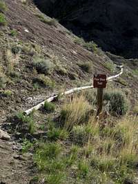 Four Bear Trail
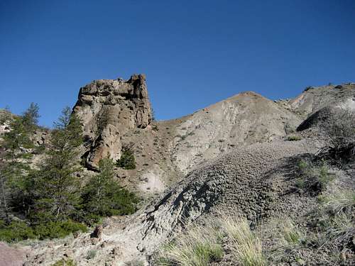
 Rock Spires
 Rock on the ridge
From here, much of the path is marked by logs on the downhill side of the trail, and brown BLM markers saying "4 Bear" are placed sporadically. This section winds down into a small canyon, hopping back and forth across a stream before coming out for good on the left side. This part has more of a forest-like feel to it, and the wildflowers are everywhere in Spring and Summer. As you get closer to the peak, you will find yourself more and more enthralled with the enormity of the sharp and grotesque spires of rock that cover the mountainside.
The final section of the trail leaves the beauty of the trees behind as it climbs up countless switchbacks through a badland area of clay washes and fantastic rock pinnacles. In spite of the harshness of the landscape, there are still flowers that grow in the most tenuous of places around these rocks. The switchbacks finally end at an open area on top of the ridge that is marked by a couple of small rock cairns. Take some time to explore the ground here, as there are fascinating specimens of rock almost everywhere you look.
From this ridge, a stunning vista opens up to the north; the views of Jim Mountain and Trout Peak are simply amazing, and the vast forest that stretches from this point away to the northeast to Pat O'Hara Mountain is also a great sight. The trail heads away to the north, where it crosses into the Shoshone National Forest after another 1.5 miles. To climb Four Bear Mountain, turn right on top of the ridge and pick your way up through the sparse forest that covers much of the summit area; the highest point is a prominent rock outcropping overlooking the steep west face of the mountain, where there is a summit benchmark.
 Jim Mountain
From the summit, you can see Cedar Mountain at the far end of the Reservoir and Sheep Mountain just across the highway. To the east, the near tree-covered summit is Logan Mountain, and the huge mass of Rattlesnake Mountain looms behind it. The southern, western, and northern skylines are made up of numerous peaks around 12,000 feet, including the long ridge of Carter Mountain to the south, the Wapiti Ridge Peaks and Sheep Mesa to the southwest and west, and Trout Peak to the north.
The Four Bear Trail to the rock cairns on the ridge is a Class 1 hike of 4.5 miles that includes 1400 feet of elevation gain; the remaining Class 2 scramble to the summit gains another 500 feet in a half mile. The total round trip distance is 10.0 miles and can be done in 4-7 hours.
 Hillside on the trail
History
In 1880, Colonel William Douglas Pickett shot four grizzly bears in one morning by one of the creeks surrounding this mountain and the area has been called Four Bears ever since. A military engineer, he designed railroads for the Confederacy during the Civil War before establishing a cattle ranch in Big Horn County in the mid 1870's. He was very famous for his exploits as a grizzly hunter, and later served in the Wyoming House of Representatives and Senate. A more detailed biography can be found in the Proceedings of the American Society of Civil Engineers archives on this site.Red Tape
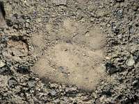 Grizzly Track on the ridge
The Four Bear Trail lies on pieces of BLM land that border the Shoshone National Forest. There is a lot of private land interspersed with the BLM land near the beginning of the hike, so stay on the trail and obey all posted signs.
As noted above, this is grizzly country; the fact that this peak lies on the very edge of the North Absarokas and is not far from major roads, subdivisions, and people does not diminish the need to be prepared for an encounter with a bear. There is also very real danger from rattlesnakes on this hike, as the majority of it crosses a lot of rocky, sage-covered landscapes.
Camping
The information sign at the Four Bear Trailhead states that camping is not allowed, but there are several campgrounds located in nearby Buffalo Bill State Park less than 5.0 miles to east. Also, if you continue north from the ridgetop cairn on the trail for a short distance, you will be inside the Shoshone National Forest, where camping is allowed.External Links
Information on the BLM siteInformation on Buffalo Bill State Park:
http://wyoparks.state.wy.us/Site/SiteInfo.asp?siteID=3
http://www.wyomingtourism.org/cms/d/buffalo_bill_state_park.php
Additional information on this hike can be found Bill Hunger's book Hiking Wyoming: 110 of the State's Best Hiking Adventures.