The page was successfully edited.

-
 17975 Hits
-
 86.85% Score
-
 23 Votes
|
|
Mountain/Rock |
|---|---|
|
|
46.85103°N / 121.62088°W |
|
|
Pierce |
|
|
Scrambling |
|
|
Summer, Fall |
|
|
7400 ft / 2256 m |
|
|
Overview
 Banshee(right) and Cowlitz Chimneys(left) from Goat Island Mountain
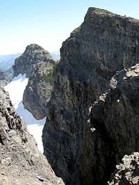 Summit Block of Banshee
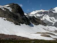 Alpine Terrain above Summerland
 Rainier from near Panhandle Gap
The approach route and destination are absolutely stunning. It will take you through the raging wildflowers of Summerland, into the barren, rocky, ice-sculpted region below Panhandle Gap, and then into soft tundra and open alpine wandering. All the while, you are greeted with amazing views of the Emmons Glacier on Mount Rainier.
Panhandle Gap is the highest point on the Wonderland Trail, the famous objective of so many backpackers and hikers. It is often a "bottleneck" along the Wonderland Trail, as all traffic coming from Indian Bar to Summerland must pass through it. The number of hikers and climbers in this area is therefore a fairly high. Accordingly, it is likely that Banshee is climbed fairly often.
In a area of unparalleled beauty, this one really stands out. It is absolutely out of this world.
Getting There
 Flowers Near Summerland
 Arriving at Summerland
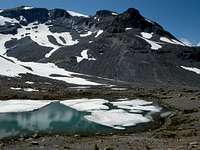 Alpine Tarn above Summerland
 Bear at Summerland
Take the Frying Pan Creek Trail 0.1 miles to its junction with the Wonderland Trail. Take the left junction of the Wonderland Trail towards Summerland (in another 4.1 miles). This trail is like a highway, wide and smooth, with barely a rock or a root. You can walk three abreast on some parts. National Park hiking at its most comfortable.
At 3.5 miles, cross Fryingpan Creek on a log footbridge (5200 feet). After crossing flowery meadows with great views of Little Tahoma and Mount Rainier, climb switchbacks 600 feet to enter the meadowy plateau of Summerland. Great campsites are found in the trees at the left of the plateau. Directly above, see Meany Crest looming over Summerland.
The Route From Summerland
 Glacial Streams and Goat Island Mountain
 Panhandle Gap
 Open slopes with Tatoosh Range
 Traversing to Banshee
Just before Panhandle Gap (about 200 yards), there is another small saddle to hiker's left through which you can hike and gain access to the slopes of Banshee Peak. Otherwise, continue on to Panhandle Gap, then traverse left to the open slopes of Banshee.
Hike the wide-open tundra slopes of Banshee another mile and another 600 feet higher, reaching the ridge and traversing to its highest point at the extreme eastern end of the ridge.
This is a fairly long day from the Fryingpan Creek Trailhead (7.5 miles each way), so you will want an early start. Luckily, most of the trip lies along very comfortable, well-graded national park trail, and is much less exhausting and hard on your body than some of the steeper, rockier trails in the state.
Trip Stats: 15 miles round-trip. Difficulty: Class 2. Elevation gain: 3600 feet.
Red Tape and Camping
 Descending Slopes of Banshee
 Cowlitz Main Chimney from Summit
 Flowerfields on Banshee
 Rainier from near Summit of Banshee
Permits are required for overnight camping in the park. They can be otbtained at the White River Guard Station. They can also be reserved over the phone, unless there is only one left. It is then given out on a first-come, first-served basis.
Camping is permitted only at Summerland. There are fantastic camps in the trees at Summerland. There is even a permanent shelter built there. Summerland has great access to running water, expansive meadows with wildflowers, and a lot of wildlife as well. As of the author's last visit there, there was a bear wandering through the meadows.
Above Summerland, there is no camping permitted until you reach Indian Bar.
External Links
 TOPO! Software Image
 Banshee and Cowlitz Chimneys
Another great site is this excellent Mt. Rainier climbing blog, which gives up-to-date snowpack and road conditions on Mt. Rainier and the all of the roads: Mt. Rainier Climbing Page