
-
 8078 Hits
-
 80.49% Score
-
 12 Votes
|
|
Mountain/Rock |
|---|---|
|
|
48.65025°N / 119.91821°W |
|
|
Okanogan |
|
|
Hiking, Mountaineering |
|
|
Summer, Fall |
|
|
7890 ft / 2405 m |
|
|
Overview
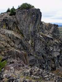
 Clark Peak East Face, May 2009
Home to the Bernhardt Gold Mine, Clark Peak is the second highest point on the ridge running north to south 15 miles northeast of the town of Winthrop in Washington State. Clark Peak shares the ridge with Mount McKay, Old Baldy, and Starvation Mountain to the south where it terminates at Lightning Creek. A mile and a half to the north, at 8245 feet, Tiffany Mountain is the highest point on the ridge. Beyond Tiffany, the ridge terminates at the North Forth Boulder Creek. The east, south, and west sides of Clark Peak are moderately sloped but the north face overlooking Whistler basin is a 500 foot cliff. The summit is a mix of rocks covered with Lichen among clusters of wild Juniper.
Route Options:
There are three main approaches to the summit. For those that intend to Summit both Tiffany and Clark, The Freezout Ridge trail 345 is the easiest approach. After a summit of Tiffany Mountain, descend back down Whistler Pass. From here the North Summit Trail 373 follows along the west side of the the ridge and can be followed south for one mile to the western slopes of Clark Peak. 500 feet of gain on easy off-trail upper meadow slopes will take you to the false summit. The last bit is a short Class 2 scramble over rocks and around bushes to the true summit.The most direct approach begins on the west side near Roger Lake. The Bernhardt Mine trail 367 was originally created to get to a historic Gold mine of Okanogan county. Prospectors continue to try their luck in the surrounding area and pan for gold dust out of the small streams near the mine. From the parking area at the bend in the road, follow an overgrown trail for a mile an a half through open meadows and burned trees to a small wooden commemorative sign for the Bernhardt Mine. Watch for cow pies littering this first part of the trail since this is a favorite grazing area for local rancher's cattle. Follow trail (if you can see it) up the steep boulder strewn slope, above the trees, to the upper meadows just below the first false summit which is a huge talus pile. Traverse left around the talus and make your way over or around the Class 2 scrambles on another false summit, to the true summit.
Another option is the Salmon Meadows trail 363 which leads up and over Clark Pass. Sections of the trail may be disrupted by an excess of fallen trees. The Isabel Fire of 2003 burned random parts of the forest and some of those trees are now falling down. It is not hard to navigate around the fallen trees and regain the trail on the other side. From the parking area (4900 feet) follow an old overgrown road for a few yards and then the trail cuts off to the left. Within minutes it crosses the North Fork Salmon Creek in two bridges. Not far from the crossing the trails splits and is marked again with a deteriorated wooden sign. The left fork leads to Clark Pass and and the summit. The right fork leads Whistler Pass and Tiffany Mountain (8245 feet). Turn left and proceed 2.7 miles to Clark Pass. Turn right (north) onto the North Summit Trail 373 for a third of a mile and the ascend east as outlined in the last two paragraphs.
Driving Directions

 A False Summit, August 2009
From Winthrop:
Bernhardt Mine Trail
Head north on East Chewuch River Road (County Road 9137) toward Pearrygin Lake State Park. In 6.5 miles (just before the road crosses the Chewuch River), turn right onto paved Forest Road 37. The pavement ends at 7.5 miles, and at 13 miles come to a junction. Turn left onto FR 39, following this sometimes rough road for 1 miles to the first major bend in the road. There should be a small sign for the Bernhardt Mine Trail next to a small stream.
Freezeout Ridge Trail
Continue another 2.2 miles north beyond the Bernhardt Mine Trail to Freezeout Pass (at a cattle guard). The trailhead and limited parking are on the right side of the road (6500 feet).
From Conconully:
Bernhardt Mine Trail
Take Okanogan County Road 2017 southwest, around the reservoir, to the junction with Forest Service Road 37. Turn right on FS 37 and continue for about 21 miles. The pavement ends at 7.5 miles. Shortly after crossing Bernhardt Creek, FS Road 39 takes off to the north. Turn right on FS Road 39 and follow this sometimes rough road for 1 miles to the first major bend in the road. There should be a small sign for the Bernhardt Mine Trail next to a small stream. If going to the Freezeout Ridge Trail, continue another 2.2 miles north beyond the Bernhardt Mine Trail to Freezeout Pass (at a cattle guard).
Salmon Meadows to Clark Pass
Drive 9 miles north on North Fork Road (this road turns into National Forest Road 38) until you reach Salmon Meadows Campground. The road splits off in several spots so be careful. At Salmon Meadows the road will curve to the left in front of the camper area and then it crosses Mutton Creek. Continue for one more mile to the parking area. The trail is marked with an old wooden sign.