
-
 3676 Hits
-
 77.02% Score
-
 8 Votes
|
|
Mountain/Rock |
|---|---|
|
|
49.15768°N / 7.81396°E |
|
|
Trad Climbing, Sport Climbing, Toprope |
|
|
Spring, Summer, Fall |
|
|
951 ft / 290 m |
|
|
Overview
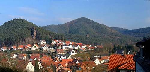 Hahnfels towering above the village of Erfweiler Hahnfels towering above the village of Erfweiler |
There are some 300 odd climbing cliffs in the Südpfalz Area, most of which are hidden deep in the valleys far away from any habitation. Quite often accessing them requires a hike of several km and even more often a steep but slippery slope needs to be climbed to get to the base of the climbs. On the other hand there are quite a number of cliffs, visible from the towns and villages of the area, sometimes even rising between the houses. Jungfernsprung and Braut & Bräutigam in Dahn are the most famous exhibts of the latter kind, the former towering above the main road through town, the latter right beside one of the most important side roads. In nearby Erfweiler there is another one, less important in terms of climbing but more exposed and most likely more beautiful: Hahnfels.
 |  |  |  |
Hahnfels is located to the east of the village right above its highest roads. A residential area is stretched out at its base and the cliff can be seen from almost everywhere. It easily is the most prominent cliff in a village in which there is no lack of them whatsoever. The most impressive view awaits you as you drive the road from Dahn to Erfweiler, which suddenly zigzags its way into the village and there it is: Hahnfels overlooking the whole village.
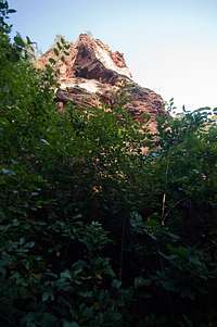
Hahnfels is what is called a massif in the region, a sandstone cliff connected to the slope of a mountain from which the top of the formation is easily accessible. However, in front of the massif there is a small standalone tower, connected at the foundation but set apart by several metres. For a crag so prominent it is hard to believe that access to the starting points of the routes is actually relatively difficult. Since its popularity is mainly restricted to its topmost part (see next section) the base of the rock has been grown over by a veritable jungle of ferns. You have to bushwhack your way to the rock with the ferns hiding much of the lower part from sight. To the north of the rock there is a big cave and an overhanging roof - the most difficult features of the whole formation.
 |  |  |  |
While there are only a handful of climbing routes, Hahnfels also is a good exhibit what may happen to a sandstone tower in the Südpfalz Area, if it is placed to close to human habitation. Someone decides that its top must be a perfect lookout pulpit and in order to offer one more attraction to tourists cables, steps and ladders are set up with a railing on top so that said tourists won't fall down admiring the views. In the case of Hahnfels - where access to the massif is easy - a bridge has been set up to connect the massif with the tower and naturally fences and railings went up all around. Unfortunately that way the old normal route (UIAA II) is almost blocked by this construction.
However, it also gave rise to the formation#s second name: Brückenfels (Bridge Rock).
Climbing Routes on Hahnfels
 Hahnfels south-east face
Hahnfels has only half a dozen routes with difficulties up to 6+. The routes were established late with the first one, Südwestkante first climbed in 1966. As so often, Hans Laub pioneered many of the routes, most of them in the 1970s and 1980s.
Rather than reprinting the copyrighted information from the site of the Vereinigung Pfälzer Kletterer I link to their routes database directly with some summary info. Here is the link to the complete database.
| Feature | Routes link | Summary |
| Hahnfels | Hahnfels | 6 routes with variations ranging from 2 - 6+ |
Getting There
 Hahnfels from downtown Erfweiler
Hahnfels is located right in Erfweiler, a 10 minute hike from the parking lot at the south-western end of the village. Erfweiler itself is hidden very deep inside Pfälzerwald and thus the itineraries are a bit longish. The closest airports are at Frankfurt and Stuttgart so the itineraries start there too.
From Frankfurt
There are two possible routes which both take equally long- Via Ludwigshafen
- From Frankfurt take motorway A5 southward to Darmstadt.
- There change to A67 south.
- At Viernheimer Dreieck turn onto A6 west. Leav
- e it at Frankenthaler Kreuz for A61 south.
- At Mutterstädter Kreuz take A65 south until you reach Landau.
- At Landau turn on B10 west.
- At Hinterweidental turn onto B427 south which will take you to Dahn.
- In Dahn, after you have driven around Jungfernsprung there is an intersection directly in the town centre. Turn off left onto K39 which takes you to Erfweiler.
- In Erfweiler don't follow the main road (K39) where it bends right to Schindhard. After some 300m there is a parking lot on th eright hand side.
- From the parking lot hike back into the village and head directly for the crag. The residential road at its base passes to the south of the formation, where a small path leads right up to the rock.
- Via Kaiserslautern
- From Frankfurt take motorway A3 west
- At Mönchhofdreieck turn onto A67 south
- At Rüsselsheimer Dreieck take A60 west
- At Kreuz Mainz Süd take A63 south
- At Kreuz Kaiserslautern turn onto A6 west
- At Kreuz Landstuhl turn onto A62 south
- At Pirmasens turn onto B10 east
- At Hinterweidental take B427 south to Dahn
- In Dahn turn onto K39 to Erfweiler
- Follow the instructions above
From Stuttgart
- Take motorway A8 to Karlsruhe
- At Karlsruher Dreieck turn north onto A5
- Tke the next exit to head for A65
- At Kandel you can leave onto B427 which will lead you directly to Dahn where you can turn right onto K39 to Erfweiler. However the detour to Landau and B10 (see above) will take less time as the roads are better (three or four lanes)
Red Tape
 Seriously doing her job!
Yes, there is red tape and lots of it. The sandstone of Südpfalz forms lots of caves and overhangs. Though this makes it most interesting for climbers, two species of birds of prey compete for this habitat: the peregrine falcons and the eagle owls. Both are endangered and wherever there is a eagle owl pair found nesting in the sandstone the crag will immediately be closed. Generally this closure lasts from the beginning of each year through Aug. 1st. If breeding is not successful the closures will be cancelled even before that date. For a list of closures see the Closure List of PK.
The cliffs on the south side of Rindsberg are rather often closed to climbing. Never all of them so you should check the link above before venturing out in the first half of the year.
The use of magnesia is not allowed in the whole Südpfalz region. This is rather a directive or an arrangement than an outright law. Thus you probably will get away with using it but do so only when absolutely necessary. Magnesia closes the pores which you find in the sandstone and together they form a smooth surface which will get very slippery in wet conditions. The rule of thumb is to use magnesia in the highest difficulty sections and only extremely sparingly.
A list of guidelines can be found here (in German).
Accommodation
You can find hotels and apartments in Erfweiler and in neighbouring Dahn. Have a look at the following links:There are two campgrounds, one in Dahn at Neudahner Weiher one in nearby Bruchweiler-Bärenbach.
Weather Conditions
Maps & Books
Maps
As for maps there is a good overview map (1:50000) by Kompass Verlag but the best ones are the official topographic maps by the state government of Rheinland Pfalz, scaled 1:50000, 1:25000 and 1:5000. All official maps can be found on the web page of Landesvermessungsamt Rheinland Pfalz
1:50000
- Naturpark Pfälzer Wald
Kompass Map WK766
ISBN: 3-85491-523-3
- Annweiler am Trifels
LVA RLP Map L6712
ISBN: 978-3-89637-191-1
1:25000
- Merzalben
LVA RLP Map 6712
ISBN: 978-3-89637-140-9
Books
There are a number of climbing guidebooks on the region of Südpfalz. The best ones, however, have been published privately and are sold only in selected bookshops of the region.
- Hiking
- Pfälzerwald
B. & J.-Th. Titz
Rother Verlag
ISBN: 3-7633-4268-0 - Klettern im Buntsandstein
U. Daigger, H.-J. Cron
Westpfälzische Verlagsdruckerei St. Ingbert
ISBN: 3-00-0155457-4
- Pfalz - Klettern im Buntsandstein des Pfälzer Felsenlands
J. Richter, S. Tittel
Panico Alpinverlag
ISBN: 978-3-936740-41-7
- Pfalz ++, Klettern im Buntsandstein
R. Burkard, P. Weinrich
Published privately
- Klettern im Naturpark Pfälzerwald
Naturfreunde Lambrecht
Published privately - Pfalz & Nordvogesen en bloc
A. Wenner, Y. Corby, I. Bald
Panico Verlag
ISBN: 3-936740-19-4
  Climbing Guidebook |
Climbing