
|
|
Mountain/Rock |
|---|---|
|
|
47.03866°N / 9.76779°E |
|
|
Hiking, Mountaineering, Trad Climbing, Sport Climbing, Scrambling |
|
|
Spring, Summer, Fall |
|
|
8373 ft / 2552 m |
|
|
Overview
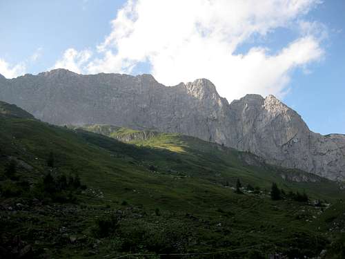
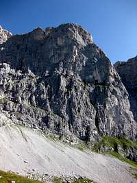
The Kirchlispitzen (2552 m) consist of seven summits wich are located on a 2 kilometers long ridge between the Cavelljoch (2239 m) and the Schweizertor (2139 m). This ridge is also the border between Switzerland and Austria. The mountain belongs to the Rätikon Group, wich is divided over Austria (Voralberg), Liechtenstein and Switzerland (Graubünden). The mountain looks pretty prominent, although it's neighbour, the Drusenfluh (2830 m) is a bit higher. The enormous South face of the Kirchlispitzen, wich stretches over 2 kilometers, and is 500 meters high, is a very popular place for rock climbers. Famous climbers like Beat Kammerlander and recently Adam Ondra have climbed some very hard routes here. The very raw limestone is very solid and steep, and requires a good climbing technique. You'll find numorous climbs, mostly moderate to very difficult. Quite a lot people probably passed the Kirchlispitzen on either the north or south side, because there are many attractive hiking routes around the mountain. Main starting points for these hikes, or the climbs, are the Schesaplanahütte, Grüscher Alp or the Douglasshütte.The seven summits are (from west to east):
- Erste Kirchlispitze: 2438 m
- Zweite Kirchlispitze: 2540 m
- Dritte Kirchlispitze: 2552 m
- Vierte Kirchlispitze: 2494 m
- Fünfte Kirchlispitze: 2428 m
- Sechste Kirchlispitze: 2370 m
- Siebte Kirchlispitze: 2350 m

Getting There
To the Schesaplanahütte (Southside/Switzerland)In general you'll start in the Prättigau area. Seewis and Fanas are located near Schiers, wich can be easily reached from Landquart or Klosters via the N28 or by train. All the acces paths are well marked.
 5th Kirchlispitze
1. Fanas, about 3,5 hours
2. Seewis, about 4 hours
3. Malbun (Liechtenstein) via Pfälzer-Hütte, about 6 hours
To Grüscher Alp (Southside/Switzerland)
Follow a very steep and narrow road to Schuders (cross the famous Salginatobelbridge). The road continues after Schuders (no tarmac, information in the only restaurant in Schuders about toll/acces!), towards Grüscher Alp. Just above Grüscher Alp there is a small parking and a cosy mountain hut. The perfect starting point for those who want to climb the South face routes!
To the Douglasshütte (Northside/Austria)
In general you'll need to enter the Brandnervalley, from the A14/E60 near Bludenz. Just follow the valley and pass Brand to reach the starting point of the Lünersee cable car.
1. Take the cable car to the hut: Lünerseebahn
2. Schlatengalanthütte (Brandnervalley) 1566 m, about 1,5 hours
Routes
Normal route of the 3rd Kirchlispitze (2552 m)The normal route runs up the less steep north side of the mountain. Normally you'll start at the Douglasshütte and head south along the Lünerlake towards the Verajöchle (2330 m). From the pass head up the north side, easy climbing (UIAA I) / scrambling, to the summit.
About 3 hours from the Douglasshütte.
First ascent: A. Ludwig 1891
Traverse
Normally the traverse is done in in east direction, so you'll start at the Cavelljoch. This exposed traverse is pretty long but not very difficult (UIAA II-III). You can leave the ridge and some points (north side). For more information see the guidebooks.
About 6 to 8 hours from the Schesaplanahütte or Douglasshütte to the Schweizertor.
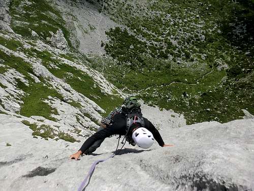
South Face
There are numerous routes on the famous South face. Most of them are pretty well bolted and easy to acces. A selection:
- Haldejohli: V. Eggenberger, F. Tschirky, L. Roffler 1981, 480m VI+/A0 (VI+ obligatoire/obligatory difficulty)
- Via Pardutz: V. Eggenberger, U. Hew 1974, 450m, VIII- (VI+)
- Galadriel: V. Luck, B. Bardill, M. Luginbühl, A. Lietha 1992-1994, 395m VIII- (VIII-)
- Kamala: K. and M. Dettling 2010, 300m, VIII (VII)
- Silbergeier: by the famous B. Kammerlander, C. Kammerlander 1994, 250m X+ (IX)
Maps and Guidebooks
Map 1:25 000:- SAC Map: 1156 Schesaplana
- SAC Map: 1157 Sulzfluh
- SAC Map: 238 Montafon
Online Maps:
Guidebook:- Topoguide Band 1, Nicole Luzar & Volker Roth, ISBN 3-00-016204-6
- Rother Guidebook: Rätikon, Günther Flaig, ISBN 3-7633-1098-3
- SAC Guidebook, Bündner Alpen 7 Rätikon, Paul Meinherz, ISBN 978-3859020993
- Kletterführer Rätikon, Mario Luginbühl, ISBN 978-3-926807-38-0
To order SAC Maps: www.toposhop.ch
To order SAC Guidebook: www.sac-cas.ch
To order the Topoguide: www.topoguide.de
To order the Rother guidebook: www.rother.de
To order the Kletterführer Rätikon: www.panico.deExternal Links
Schesaplana Hütte SAC - 1908 m
Hans Gansner
Bühel 157
CH-7212 Seewis
Phone (hut): +41 (0)81 3251163
Homepage:www.schesaplana-huette.ch
Douglasshütte OEAV - 1976 m
Fam. Schedler - Saurer
Mühledörfle 72
A 6708 Brand
Phone (hut): +43 (0)664 441 237 8
Homepage:www.douglasshuette.at
Other useful links:
Weather forecast
Avalance Bulletin
Time Table Bus Austria
Time Table Train Austria
Railroad information Switzerland
Bus information Switzerland
Additions and CorrectionsPost an Addition or Correction

hgrapid - Sep 15, 2009 2:24 pm - Hasn't voted
Error in termsLocation: Europe County: Austria, Switzerland Location should be the country County is applicable for the U.S., not Europe
Jurgen - Sep 15, 2009 3:50 pm - Hasn't voted
Re: Error in termsOeps..you're right. I've changed it. Thanks!