
-
 7311 Hits
-
 82.48% Score
-
 15 Votes
|
|
Mountain/Rock |
|---|---|
|
|
46.78290°N / 12.28469°E |
|
|
Hiking, Skiing |
|
|
Summer, Fall, Winter |
|
|
8737 ft / 2663 m |
|
|
Overview
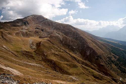 Toblacher Pfannhorn / Corno Fana seen from Roßzagel / Monte Cavallo Toblacher Pfannhorn / Corno Fana seen from Roßzagel / Monte Cavallo |
The Villgraten Group (Villgrater Berge) is the southernmost subgroup of Hohe Tauern. While its summits don't exceed 3000m they nevertheless are all excellent lookout peaks, thanks to the fact that the group is wedged between the glaciated Tauern main mountains and the huge area which comprises the Dolomites and the Carnic Alps. Especially the southern mountains of the group have gained some renown and this page will guide you to one of the most important ones of them: Toblacher Pfannhorn / Corno Fana.
 |  |  |
While the main ridge of the Villgraten Group runs in east-westerly direction in the north of the group, several long side ridges leave it in southerly direction. The longest one of these starts at Riepenspitze and heads all the way down into the uppermost Pustertal Valley / Val Pusteria. Since the end of WW I its crest has made up the border between Austria and Italy, a border which (like the ridge) runs from north to south, only to bend eastward high above the Valley. Toblacher Pfannhorn / Corno Fana is exactly the cornerstone mountain at this bend, a location which immediately explains its tourist significance: here you will have unobstructed views across the many mountain groups around.
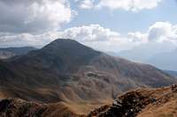
 Toblacher Pfannhorn / Corno Fana as seen from Gaishörndl / Cornetto di Fana
However, reaching Toblacher Pfannhorn / Corno Fana is a longish undertaking. The village of Toblach / Dobbiaco in its south is located at an elevation of only 1200m, which leaves a whooping 1400m - 1500m to be climbed towards its summit. On the Austrian side, in Villgraten Valley, matters are different but even here 1000m have to be scaled. Both climbs are easy, the slopes of the mountain are far from steep, and on a good day you will find crowds of people on the summit. Most of them will come from the Austrian side, where Toblacher Pfannhorn / Corno Fana is much popular than in the south. Still, the South Tyroleans have established a panoramic high route on their side of the border, named Toblacher Höhenweg. It follows the ridge around Pfannhorn for some 15km, touching seven named summits: Blankenstein, Spitzkinkele, Toblacher Pfannhorn, Gaishörndl, Hochhorn, Golfen and Roßzagel. The route resembles the start of Karnischer Höhenweg to the south-east across Pustertal Valley / Val di Pusteria and is one of the most scenic routes in an area where there is no lack of scenery.
 |  |  |
However, the position of Toblacher Pfannhorn / Corno Fana also has a downside: at times before the Schengen Treaty, when there still were border controls in Europe, an astonishingly large number of customs huts were maintained on the Italian side of the crest. For decades they have now been left to crumble away, leaving ugly scars in the slopes of the summits. On the upside, most of the trails of the area also date back to that time. And finally: when climbing Pfammhorn across the south route, ddon't forget a visit to Pfannhornhütte / Rifugio Corno Fana (former Bonner Hütte), a small mountain hut, beautifully restored. At an elevation of 2300m, its views already rival the ones on the summit.
Toblacher Pfannhorn / Corno Fana and all its neighbours are excellent destinations for tour skiing in winter. Basically every summit can be climbed and there are countless possible descent routes all over the place. Most popular starting point in winter is the ski slift on Thurntaler, which heads up from Sillian. From there you can ski the whole ridge to Pfannhorn and further - much further.
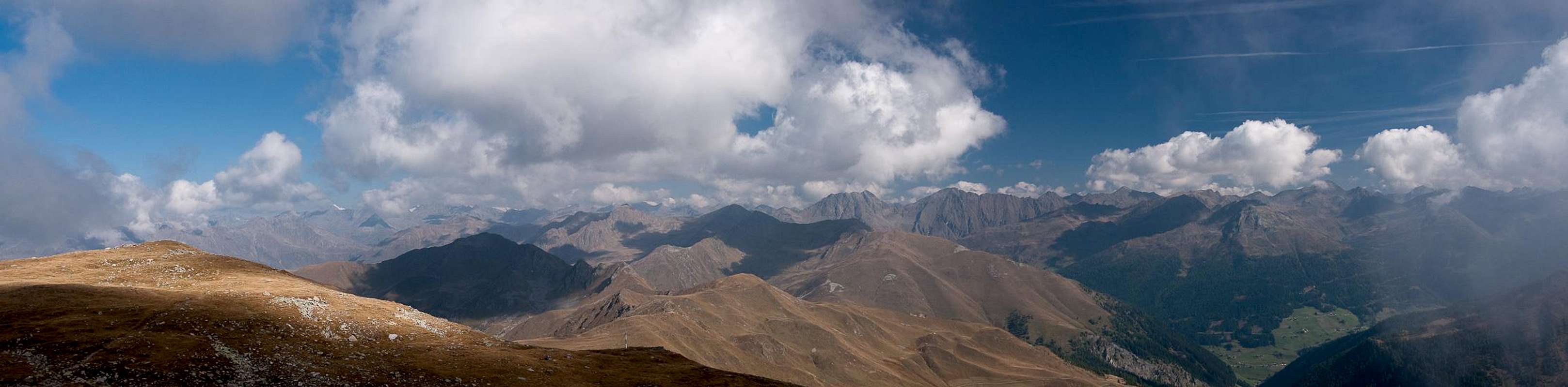
Summit Panorama Toblacher Pfannhorn / Corno Fana
  |
Getting There
 |
The best starting points for an ascent of Toblacher Pfannhorn / Corno Fana are at Toblach / Dobbiaco in its south or Innervillgraten to its north-east.
- Leave the Brenner Motorway near Brixen / Bressanone and follow SS49 to the east through Pustertal / Val Pusteria.
- At Toblach / Dobbiaco turn northwards for Silverstertal Valley / Valle San Silvestro
- Park your car at the bridge across Silvesterbach Creek
- For Innervillgraten pass Toblach / Dobbiaco and Innichen / San Candido
- Cross the Austrian border on B100
- At Sillian turn north in towards Außervillgraten, Innervillgraten and Kalkstein.
- From Kitzbühel over B108 through the Felbertauern Tunnel to Lienz
- Then southeast to Oberdrauburg (B110)
- Turn on to B100 west into Pustertal.
- Go through the city of Lienz until you get to Sillian.
- There turn north to Außervillgraten, Innervillgraten and Kalkstein.
- For Toblach / Dobbiaco stay on B100 / SS49. Later turn right for Silvestertal.
- From Salzburg along motorway A10 to Spittal.
- Turn west on B100 to Oberdrauburg, Lienz and Sillian (and Toblach / Dobbiaco).
Red Tape
No red tape here. However, remember that you are in the border region between two countries. Carrying an ID is not a bad idea.Accommodation
Weather Conditions
Maps & Books
Maps
- Sextener Dolomiten / Dolomiti di Sesto
1:50000
Kompass Map WK58
Kompass Verlag
ISBN: 3-87051-065-X
- Bruneck - Toblach / Brunico - Dobbiaco
1:50000
Kompass Map WK57
Kompass Verlag
ISBN: 3-85491-064-9
Books
- Osttirol Süd / Tirolo Orientale Sud
W. Mair
Rother Verlag
ISBN: 3-7633-4132-3
ISBN: 3-7633-4307-5 (Italian)
- Pustertal
E. Hülsler, M. Kostner
Kompass Verlag
ISBN: 978-3-85026-015-2
- Rother-Skifuehrer "Pustertal"
Rudolf and Sigrun Weiss
Rother Verlag, 2004
ISBN-3-7633-5911-7
Vid Pogachnik - Oct 18, 2009 5:50 am - Voted 10/10
Good addition!Thanks for adding T. Pfannhorn, Gangolf. I think it is worth mentioning somewhere on the page that this mountain is also one of the most popular goals in winter/spring season, because it offers great ski descents. Cheers! Vid
Gangolf Haub - Oct 18, 2009 6:22 am - Hasn't voted
Re: Good addition!Oops - simply forgot to mention it. I had already put up "skiing" as an activity but as usual forgot about it in the text. The whole ridge must be a wonderful destination for you tour skiers!