
-
 10877 Hits
-
 86.37% Score
-
 22 Votes
|
|
Area/Range |
|---|---|
|
|
28.99964°N / 13.74534°W |
|
|
Spring, Summer, Fall, Winter |
|
|
1673 ft / 510 m |
|
|
Introduction
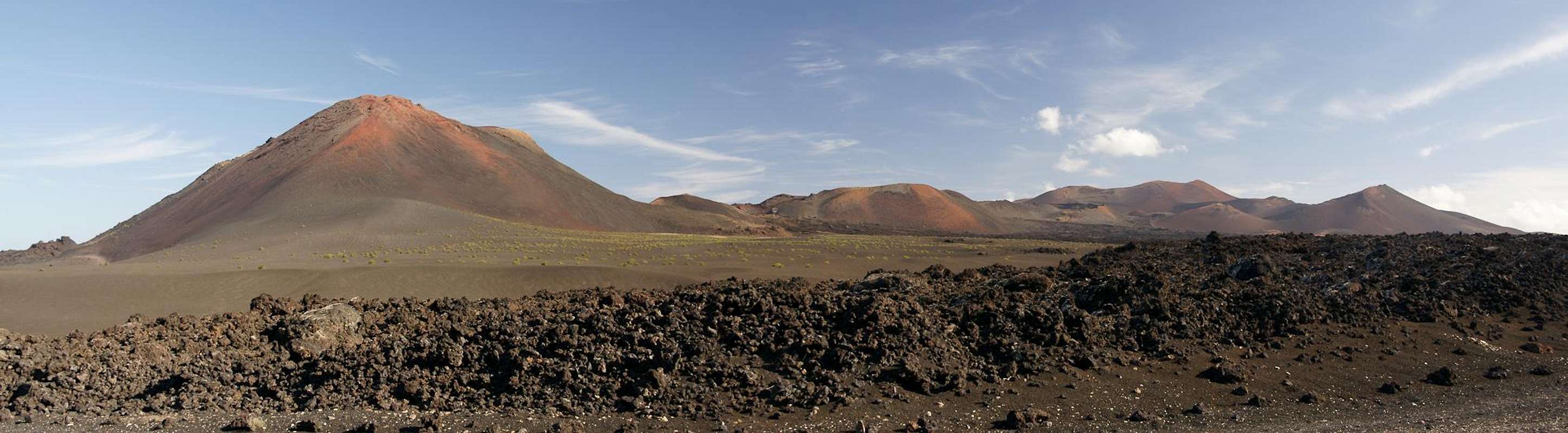
 Montaña de Pedro Perico, Montaña Hernandez Montaña de Pedro Perico, Montaña Hernandez |
Las Montañas del Fuego on the island of Lanzarote among the Islas Canarias are one of the most impressive mountain ranges on earth. The name mountain range might seem a little far fetched, given the fact, that the range's highest summit does not even reach 600m / 2000feet, but this mountain range can shed quite some light on the creation of mountains by volcanism. Most of the range is part of the Parque Nacional de Timanfaya in which activities are strictly limited and overlooked.
Many of the pictures have been taken on a guided tour, a 5km hike through the western part of Timanfaya National Park. Daily only 16 people are allowed to take part in this tour, which is a once in a lifetime chance to see the area up close.
Don Andres Lorenzo Curbelo
  |
”Today, on the first of September 1730, between 9 and 10 pm., the earth tore open near Timanfaya, two leagues from here.”
Thus begins the diary entry of Don Andres Lorenzo Curbelo, the parish priest of Yaiza, a village in the south-east of Lanzarote, which deals with the longest historical eruption on the island.
“A huge mountain formed in the first night already and flames shot out from its summit, burning for 19 further days. A few days later a new crater emerged and the lava flowed across Timanfaya, Rodeo and parts of Mancha Blanca. The Lava flowed towards the north, at first like gushing water, later viscous like honey. But on Sept 7th a huge rock rose out of the earth with an ominous rumble, forcing the lava to flow west and north-westward. There it destroyed Maretas and Santa Catalina.
 |  |  |
On September 11th the activity of the lava renewed. It covered and burned Mazo whereafter for eight days a fiery cataract plunged into the sea with a fearful roar. Huge amounts of dead fish floated on the surface and were thrown upon the coast. Afterwards everything calmed down and the eruptions ceased.
But on October 18th three new craters opened up directly above the burned Santa Catilina, spilling huge clouds of fumes, which covering the whole island with sands and ashes. The gloom they produced repeatedly forced the people of Yaiza to leave their village."
Timanfaya used to be a village in the fertile south-west of Lanzarote, which during the first onslaught got buried by cinder and lava. 12 more villages were to follow, taking with them 420 dwellings into oblivion. Some of today's volcanoes are named after the villages but apart from this no trace remains. The eruptions lasted for 5 ½ years until April 1736 making this eruption one of the longest eruptions in recorded history. The lavas covered an area of almost 200 square kilometres or roughly one fourth of the island's area. The island's boundaries were extended in the north where lava streams formed a wild new coastline, impressive even still today. No humans died, most likely because these eruptions had been preceded by years of quakes and rumbles.
Parque Nacional de Timanfaya / Red Tape
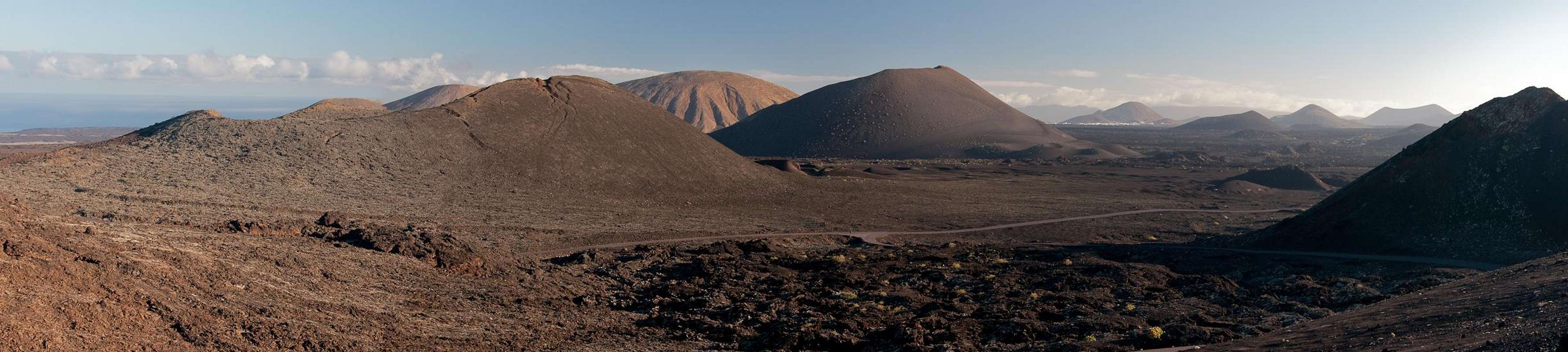
 Caldera Colorada
Of these 200 square kilometres one fourth, 50 square kilometres around the epicentre of the 1730 eruptions have been set aside as a national park, the Parque Nacional de Timanfaya. Except for a few (four) places the park is strictly off limits for any non scientist. The dry weather of Lanzarote ensures that colonisation of the lavas by plants and animals occurs in super slow motion. In the last (almost) 300 years only different varieties of lichen have gained a foothold, making them the first pioneers in a hostile environment. Actually the lichens have been very successful: 200 different types have been counted from which no more than 80 have been scientifically classified. However the time it takes for this kind of colonisation is immense; a ranger showed us a place where a car had driven off-road more than a decade ago. You were still able to see the tracks, where the lichen population had been destroyed.
 |  |  |
The four activities you can perform in Timanfaya National Park are:
- Ruta del Litoral, a path through the malpais along the northern coast. It is a 9km trail, which you can explore on your own – the only such activity. 9km through the malpais (“badland”, the towering lava fields) can take a whole day to hike.
- Timanfaya Guided Tour. It is a once in a lifetime chance to see the park up close. You have to apply at least three weeks before the desired date and only people older than 18 and younger than 70 qualify. Each day 16 persons can take part in one of the tours, which is why your personalia are taken before the start. The tour is a 5km, 2h hike through the westernmost part of the park. You are guided by qualified and very engaged park rangers.
- Ruta de los Volcanes, Islote del Hilario. This is the most popular of the tours. For a fee of 8€ per person you can drive inside the park to a place, called Islote del Hilario. The place – an “island” which never was covered by the lavas of the eruptions – is nevertheless the hottest spot in Lanzarote. Guides perform a couple of stunts like kindling fire from the heat of the earth or producing geysers by pouring buckets of water down tubes which lead into the hot ground. In the place an restaurant has been erected, where food is barbecued on a “volcano grill”. From Islote del Hilario you can take a bus ride along the Ruta de los Volcanes, a paved road, which leads through the epicentre of the eruptions. While not an outdoor activity, it is still recommendable – if you are prepared to pay the fee.
- Dromedary Riding. This is the ultimate tourist attraction. There are currently 210 dromedaries which take the tourists up a 500m – 1km loop into the Montañas del Fuego. Not overly interesting, imho.
To get an overview over the Montañas del Fuego, I can recommend Montaña de la Cinta to the south-west of Yaiza, the mountain from which Don Andres Lorenzo Curbelo observed and recorded the eruptions.
Geographical Overview
 |
A look at the interactive map below reveals the origin of the Montañas del Fuego. A fault line opened beneath the surface preceding the 1730 eruption along which magma rose to the surface. After years of quakes finally at the site of the vanished village of Timanfaya – visible on the satellite map left of LZ67 – the first and most violent eruption took place, eventually piling up Montaña Timanfaya, the highest summit of the area.
|
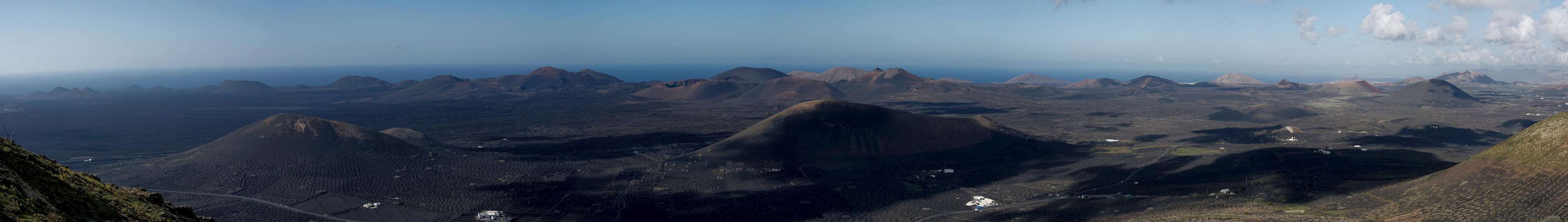
The Montañas del Fuego take all the area between El Golfo in the west (half of it's crater has already eroded by sea tides) and Masdache in the east. The last of the volcanoes to erupt was Caldera Colorada, the crater of which shines brightly red when seen from the east. The Montañas del Fuego covered about 200 square kilometres of the island with their lavas. Out of these “seas of lava” occasionally older volcanoes rise like islands, Caldera Blanca or Montaña de Vieja Gabriela being the most important ones.
 Montaña del Golfo with its green lagoon
In addition to the Parque Nacional de Timanfaya the Montañas del Fuego have been protected also by the the Parque Natural de los Volcanes, which surrounds the National park like a half-circle.
Getting There
 |
Though there are ferries from the Spanish mainland to the Canary Islands, they take more than 24h for the trip. Therefore most visitors therefore go by plane. Every travel agency in Europe offers flights, hotel rooms, apartments, rental cars etc. so that reaching the Canaries is rather a matter of money than opportunity. During the summer season flight fares can be reasonable but during the Easter and Christmas holidays you have to be prepared for additional fees of 500€ per person.
Lanzarote has its own airport between the capital Arrecife and one of the main tourist centres, Puerto del Carmen. There are public bus lines but – like on all the islands – they don't run too regularly. If you plan to stay on your own, better take a rental car right at the airport.
There are several trailheads from where you can reach the Las Montañas del Fuego. Most of them are on LZ67, the road which goes right through them. You can reach it as follows:
- From Arrecife follow LZ20 through San Bartolomé.
- At the Monumento del Campesino turn onto LZ30 west.
- Drive through Masdache and La Geria until you reach Uga.
- There turn on LZ2 to Yaiza.
- In Yaiza follow the signs for Las Montañas del Fuego.
Accommodation
 |
For holiday homes, hotels or apartments either consult your nearest travel office, or – search for lodgings on Google. There are several sites on the web, dedicated to rent privately owned houses or apartments. Prices are generally a bit less expensive than for tour operators but you don't have as much security.
Weather Conditions
As stated in the overview section, Lanzarote, is usually swept by fierce north-western trade winds. Though they deposit their humidity on almost all of the other Canary Islands, Lanzarote is simply too low to form a decent obstacle. Therefore the climate is very arid.
For some time of the year, eastern winds prevail, which almost always carry clouds of Sahara dust with them. Usually this means reduced visibility but in some occasions "Calima" occurs. Fierce storms take up the dust from the Sahara and sweep it across the islands. In these times visibility is nil and sometimes even the planes are grounded.
Maps & Books
Maps
Regular Maps
- Lanzarote
Kompass Map WK241
Kompass Verlag
1:50000
ISBN 3-85491-175-0
Digital Maps
Kompass is the only company known to me which offers GPS digital Maps. In addition for those of you with Garmin GPS receivers there is a map source map set of all Canary islands out there.
- Lanzarote
Kompass GPS4241
Kompass Verlag
ISBN 3-85491-223-4
- Islas Canarias
Map Source custom map
By Manfred Pepper
downloadable zip-file
Books
My recommendation is a guidebook by Rother Verlag, available in German. The book is an excellent hiking guide covering all the interesting areas of the island. Since it comes with small maps for each excursion it might even be used without a map to support them.
- Lanzarote
Rolf Goetz
Rother Verlag
ISBN 3-7633-4302-4