
-
 11908 Hits
-
 84.27% Score
-
 18 Votes
|
|
Mountain/Rock |
|---|---|
|
|
45.16090°N / 117.1376°W |
|
|
Wallowa |
|
|
Hiking, Skiing |
|
|
Spring, Summer, Fall, Winter |
|
|
8274 ft / 2522 m |
|
|
Overview
Just barely inside the Eagle Cap Wilderness, on the edge of the Hells Canyon Wilderness in northeastern Oregon, is Mount Nebo. Not named after the little fish in that Disney movie or the sub captain (said with a head cold), this one is more related to sheep than to anything marine. The area around Mt. Nebo is still used for sheep grazing and reportedly, this hikeable peak was named for the mountain from the Bible by one of the more religious sheep herders in the area. This area has been used for grazing since the 1800’s. There are still one sheep and two cattle allotments permitted here and the sheep graze in the Mount Nebo area from early July to September.
Don’t let this fool you though, chances are you won’t see them and this is still the Wallowas. It’s the more arid east side, but this peak is still over 8000 feet and the views of the interior are wonderful. The summit meadow is a great spot to relax and see everything from the Matterhorn and Seven Devils Area in Idaho. This peak doesn’t come with such a high effort as those though, the hike is only about 3.5 miles (estimate since there is some off trail hiking) one way with about 1800 feet of elevation gain. We used this hike as a nice easy way to cap off a week in the Wallowas and it fit the bill perfectly. While most of the hike is in forest, there are still nice views of the surrounding peaks and once you hit the summit ridge, the whole Eagle Cap Wilderness opens up to you.
Getting There

From Joseph heading south on the main drag (Wallowa Lake Highway Route 82) turn left onto Imnaha Highway (it's called Airport Lane to the right at that intersection). Head east for 7 to 8 miles to the Wallowa Mountain Loop Road (obvious and signed). Turn right onto Wallowa Mtn. Loop Road and proceed around 13 miles (give or take a few) to the road on the right for Tenderfoot Trailhead/Nordic Ski Shelters. (As I recall, this was not marked very well. It's a gravel road that heads up to the right. It should be the first road to the south of the Salt Creek Summit Snow Park.) Follow this road a couple to several miles to its end at the trailhead.
Red Tape
I do not believe there was any pass required but don't quote me, those stupid Forest Service Passes are required most everywhere.
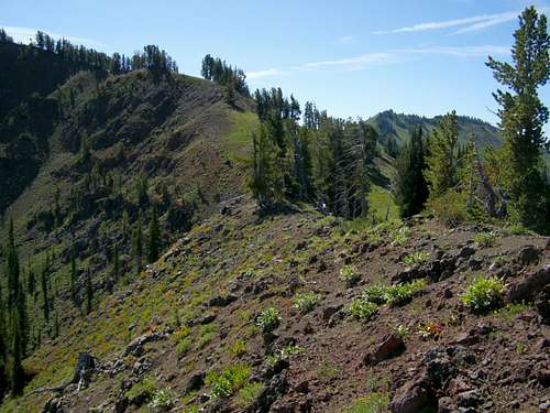
Aneroid Peak and some late summer flowers from Nebo. (Bonneville Mountain peeking over the saddle.)
Camping

There are spots in the woods along the way and flat spots as you gain the summit ridge but nothing permanent or official. The nearest established campground is a couple miles further south on Wallowa Mountain Loop Road called Lick Creek Campground. There is ample water (must filter from the creek) and a self-serve drop box for fees.
Mountain Conditions
Eagle Cap Ranger District88401 Highway 82
Enterprise, OR 97828
(541) 426-4978