
-
 4908 Hits
-
 83.1% Score
-
 16 Votes
|
|
Mountain/Rock |
|---|---|
|
|
46.59916°N / 12.68546°E |
|
|
Hiking, Scrambling |
|
|
Summer, Fall |
|
|
8094 ft / 2467 m |
|
|
Overview
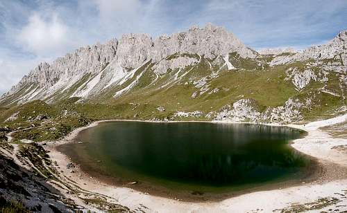 Cresta Righile above Laghi d'Olbe Cresta Righile above Laghi d'Olbe |
I must admit that I'm not sure whether this page should be a mountain, area or even route page. It deals with a long ridge, which runs between Monte del Ferro in the south of the Monte Rinaldo Group on the Carnic Alps Main Ridge towards Monte Lastroni in the east. It consists of a big number of limestone towers of regrettably low rock quality and only the two endpoints of the crest can be reached via regular hiking trail. Most of the towers in between are off limits and only a good measure of insanity would make you climb them.
But then, in the years between 1915 and 1918 enough insanity combined to make the Carnic Alps the theatres for one of the most heavily contested mountain wars in all time.The main ridge was the front line and to both sides fortifications were raised. Cresta Righile (also Cresta del Ferro) was strategically important as it overlooks Val Visdende, which separates it from the main ridge as well as the Piave Valley to its south. Access from the Austrian north was difficult due to the big scree fields at the base and thus the Italian Alpini set up dozens of positions on the crest.
 |  |  |
Main access was from the south from Sappada across the plateau on which lie the Laghi d'Olbe, three alpine lakes. The central access point was (and is) Passo del Mulo, the only reasonable crossover point on the ridge. At the pass the ridge bends - one branch heads south-westward towards Monte del Ferro, the other heads eastward towards Monte Lastroni. To reach the numerous positions a crest trail was established, which ran across the ridge near its very top. Today, much of this trail has fallen into disrepair, especially the eastern part of it. Here a second support trail headed for Monte Lastroni. It is the path, which still is in use to reach the mountain. The crest trail has virtually been forgotten.
 |  |  |
However, the south-western branch between Passo del Mulo and Monte del Ferro is still "in use". It winds between the towers on the crest, often staying on the north-western side. The low rock quality, however produces constant rockfall and the path is in poor condition. In places it has been covered by scree slides in others it has dropped into the abyss. Protection is almost impossible, which makes the crest outright dangerous. We climbed the first third of it before the lack of time gave us a pretext to turn and head back down. Still, with more time, I would like to explore more of the route, maybe from the southern side from Monte del Ferro.
 |  |  |  |
Name: the south-western branch of the ridge runs between Monte Righile in the north and Monte del Ferro in the south. Both names are used today to describe the crest.
Panoramic View
  |
Getting There
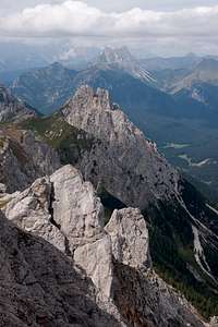
 The eastern part of Cresta Righile
The trailheads for Monte Lastroni are located in Val di Sesis, the valley, which leads from Cimasappada to the sources of the Piave River. The eastern trailhead is at Baita del Rotodendro, the northern one at the Rifugio Sorgente del Piave.
From Veneto
- Take motorway A27 from Venezia (Venice) to Ponte nelle Alpi
- Take SS51 (Alemagna) to Pieve di Cadore
- Take SS51bis to Lozzo di Cadore
- Take SS52 to Santo Stefano di Cadore
- Take SR355 to Cimasappada
From Südtirol / Alto Adige
- Take Brenner motorway A22 to Bressanone (Brixen)
- Take SS49 through Val Pusteria (Pustertal) until you reach Innichen (San Candido)
- Take SS52 (Carnica) to Santo Stefano di Cadore
- Take SR355 to Cimasappada
From Austria (Lienz)
- Take B100 from Lienz to the Austrian / Italian border
- Take SS49 to Innichen (San Candido)
- Take SS52 (Carnica) to Santo Stefano di Cadore
- Take SR355 to Cimasappada
Red Tape
 Cresta Righile as seen from Monte Lastroni
No red tape in this area.
Accommodation
Weather Conditions
 |
Maps & Books
Maps
- Tabacco Map 001
SAPPADA-S.STEFANO-FORNI AVOLTRI
1:25000
ISBN: 978-8883150012
Maps Online
Books
- Friulanische Dolomiten & Karnische Alpen
Ingrid Pilz
Carinthia Verlag
ISBN: 978-3853785959