
-
 4710 Hits
-
 81.84% Score
-
 14 Votes
|
|
Mountain/Rock |
|---|---|
|
|
46.71212°N / 12.01767°E |
|
|
Hiking, Skiing |
|
|
Spring, Summer, Fall, Winter |
|
|
7927 ft / 2416 m |
|
|
Overview
 Flatschkofel / Col Valacia seen during the descent from Maurerkopf / Monte Muro Flatschkofel / Col Valacia seen during the descent from Maurerkopf / Monte Muro |
The Olanger Köpfe, a line of six summits in the north of the Prags / Braies Dolomitesseperate into three distinctive groups. To the west you have Piz de la Perez / Pizzo delle Pietre (2507m) and Dreifingerspitze / Punta Tre Dita (2479m) rising above Furkelsattel / Passo Furcia. To the east there are Maurerkopf / Monte Muro (2567m), Hochalpenkopf / Cima dei Colli Alti (2542m) and Kaserkopf / Punta Casera (2414m) towering above the village of Olang / Valdaora, after which the subgroup has been named. Only one summit stands alone, right in the middle of the Group: Flatschkofel / Col Valacia.
Located between Lapaduresjoch / Ju dies Slapadures und Flatschkofelscharte / Forca Valacia, Flatschkofel / Col Valacia is a typical representative of Olanger Köpfe and the Prags / Braies Dolomites as a whole. While its north face rises for several hundred metres above Pustertal / Val Pusteria, its southern side is a mere grass covered slope, which is not even steep. The summit can be so easily reached that nobody bothered to set up a marked trail. You simply walk up the broad back to the summit cross.
The mountain is made up from the typical Prags / Braies Dolomites mess of sandy limestone and dolomite. The faces to its north are a half circle of vertical rubble. Any attempt to climb them will end in a big rock slide. Also, it is obvious that the hiking trails avoid running under Flatschkofel's north face. To make matters worse, several deep rutted gullies run north-westward towards Langental, difficult to traverse and dangerous during snow melting times.
 Hochalpe beneath the summits of the central Prags / Braies Dolomites
The south slopes of Flatschkofel / Col Valacia are the westernmost part of the Hochalpe / Colli Alti one of the largest mountain pastures in the Alps. It is famous for the many horses, which live there in summer and which can be anything between trusting, curious and outright intrusive. In spring and early summer the pasture turns into a giant bed of wildflowers, another reason for its popularity. During winter, a ski route leads up through Langental from Bad Bergfall / Bagni di Pervalla in the north of the mountain. It runs through Lapaduresjoch / Ju dies Slapadures and climbs the mountain from the south. On good days you have wonderful views of Hohe Tauern to the north of Pustertal / Val Pusteria.
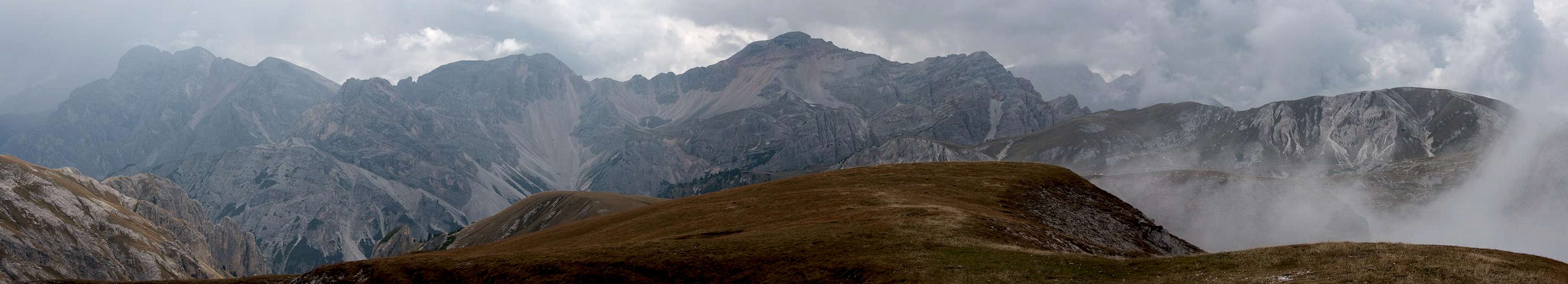
Summit Panorama towards the Prags / Braies Dolomites
  |
Getting There
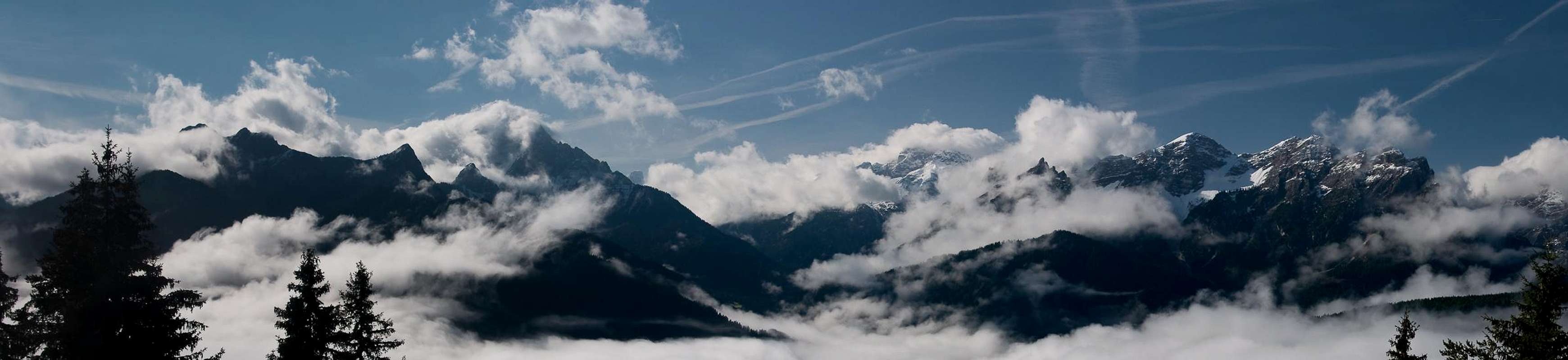
 Summit "view" towards Pustertal and Maurerkopf
The best trailhead for Flatschkofl / Col Valacia is at Pragser Wildsee / Lago di Braies in the east of the mountainIt can be easily reached from Toblach / Dobbiaco.
From The North
- Take A22 Brenner Motorway to exit Brixen / Bressanone
- Turn off onto SS49 east to Bruneck / Brunico or Toblach / Dobbiaco
From Austria (East)
- Take A12 Inntalautobahn to exit Kufstein.
- Turn onto B178, later B161 south in direction Kitzbühel.
- At Mittersill B161 turns into B108 which heads through Felbertauern Tunnel.
- Take B108 until Lienz were you turn right (west) onto E66 which on the border crossing turns into SS49 to Toblach / Dobbiaco and Bruneck / Brunico.
From Udine
- Take A23 north to exit Carnia.
- Turn off onto SS52 which leads through several detours to Innichen / San Candido
- Turn east on SS49 to Toblach / Dobbiaco and Bruneck / Brunico.
From Venezia
- Take motorway S27 north towards its end near Belluno.
- Turn onto SS51 towards Cortina d’Ampezzo and on to Toblach / Dobbiaco.
Red Tape
In 1980 an area of 25680ha has been set aside for the natural Park Fanes Sennes - Prags. You are required to treat the Natural Park with care: leave animals and plants in their place, use trails (especially when mountain biking), and take the official open roads with your car.For more information you can look at the parks official website
Be prepared to pay small fees (3€) for the parking lot at the trailhead.
Accommodation
For hotels and apartments have a look at the websites of the towns and cities of the area:Weather Conditions
 |
Maps & Books
Books
The Prags Dolomites / Dolomiti de Braies are not as well covered in terms of Guidebooks. The list below offers the German books I know of dealing with the area but there certainly are more, especially Italian ones.
- Dolomiten 5 - Sexten - Toblach - Prags
F. Hauleitner
Rother Verlag
ISBN: 3 7633 4199 4
- Dolomiten
P. Fleischmann
Kompass Verlag
ISBN: 3 8705 1409 4
Sextener Dolomiten extrem - Alpenvereinsführer
R. Goedeke
Rother Verlag
ISBN: 3 7633 1255 2
Maps
The most commonly used maps are the ones by Kompass and by Tabacco. The Kompass one is good as an overview map while the Tabacco one offers more details.
- Bruneck - Toblach / Brunico Dobbiaco
Kompass Map WK 57
ISBN: 3 85491 064 9
Scale: 1:50000
- Dolomiti di Braies / Pragser Dolomiten / Marebbe / Enneberg / Plan de Corones / Kronplatz
Tabacco Map 031
Scale: 1:25000