
-
 15069 Hits
-
 78.27% Score
-
 9 Votes
|
|
Trailhead |
|---|---|
|
|
48.37159°N / 113.27981°W |
|
|
Glacier |
|
|
Spring, Summer, Fall, Winter |
|
|
5065 ft / 1544 m |
Overview of the Lubec Lake Trailhead:
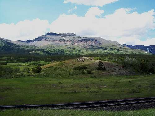 Lubec Lake trailhead
The Lubec Lake Trailhead is located on the southeast side of Glacier National Park.
U.S. Highway 2 between West and East Glacier weaves between the mountain in the Flathead Range to the west and the incredible peaks of the Clark Range in Glacier National Park to the East.
The highway follows the Middle Fork of the Flathead River as it forms the boundary of the southwestern side of Glacier National Park and actually passes through a small portion of the park to the East of Essex, Montana. Just east of the park U.S. Highway 2 follows Bear Creek to Marias Pass. Marias Pass was influential for the Transcontinental Railroad and was “discovered” by John Stephens as he search for a rail route through the mountains.
For more information on Marias Pass see: Centennial Series: A History of Glacier National Park’s Passes: Part I.
It is just below Marias Pass at what is called the “False Summit” that the Lubec Lake Trailhead is located.
In the past there was a Glacier National Park patrol cabin located along this trail. It is no longer there. The trail starts out as a road and eventually becomes a single track trail as it approaches the junction of the Autumn Creek Trail.
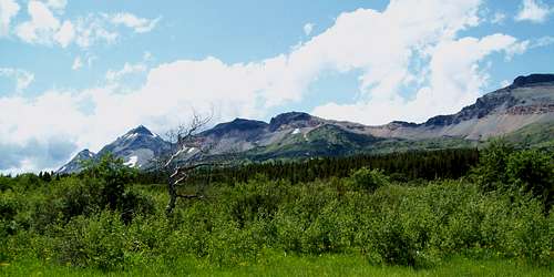 Lubec Lake trail
Mountains Accessed from the Trailhead:
Calf Robe Mountain
Dancing Lady Mountain
Red Crow Mountain
Routes Accessed:
Calf Robe Mountain, Firebrand Pass Route
Calf Robe Mountain, Northeast Ridge Route
Red Crow Mountain, Firebrand Pass Trail
Red Crow Mountain, Lena Lake Route
Trailheads:
The Lubec Lake Trailhead is a primary access point along the southeastern side of Glacier National Park. Other trailheads include Autumn Creek Trailhead (Marias Pass Access Point, Fielding/Coal Creek Access, another Autumn Creek access point west of Marias Pass and East Glacier.
Directions to the trailhead:
The trailhead is located at mile marker # 203 on U.S. Highway 2 between Marias Pass and East Glacier. Montana.Accessing the Trailhead:
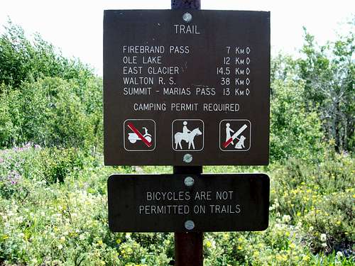 Trailhead Sign
The parking area for this trailhead is along the BNSF Right of Way and the road is somewhat difficult to spot if traveling too fast. Decrease the vehicle speed to below 15 mph before turning off the road. There are actually two roads one at the mile marker and another just to the east of the 203 mile marker.
Finding a convenient place to park is not difficult. After parking in the parking area walk across the railroad tracks, being especially cautious to look for the Amtrak passenger train passing two times daily cruising through this section at around 60 to 70 mph. There are also NUMEROUS freight trains that must be avoided as well. Look and listen BEFORE crossing the railroad tracks!
Look for the trailhead sign near a gate. There was an old road here in the past but it has been abandoned for some time.
This sign designates the following distances to the following destinations:
I do not know why the park has this sign with only metric designation but this is the actual sign.
Firebrand Pass (7.0 km)
Ole Lake (12.0 km)
East Glacier (14.5 km)
Summit - Marias Pass (13.0 km)
Other Information:
 View of Lubec Lake TH from Calf Robe Mountain
Trail Status for Lubec Lake Trailhead
The USGS quad maps associated with this area are Squaw and Summit.
Get a Glacier National Park map from a local sporting goods store or locate them here at 7.5 Minute Topo Maps for Glacier National Park and then download them for free.
There may be little water on this route after leaving the valley floor.
This is bear country! Bring bear spray and know how to use it.
As with all hiking and climbing in Glacier National Park use caution and practice good manners with the wildlife. You are in bear country. Carry bear deterrent spray, don’t hike alone and make some noise. For more information please go to the Park's web site for Bear Information. The U.S. Forest Service also has helpful information on Grizzly Bear Management.
Camping is available at the USFS Marias Pass campground.