
-
 3141 Hits
-
 82.48% Score
-
 15 Votes
|
|
Mountain/Rock |
|---|---|
|
|
44.43590°N / 108.9559°W |
|
|
Park |
|
|
Hiking, Scrambling |
|
|
Spring, Summer, Fall, Winter |
|
|
5978 ft / 1822 m |
|
|
Overview
 Near the summit
Peak 5978 is a fun little mountain that is located south of Cody, Wyoming in the Big Horn Basin. It is about five miles from any other ranked summits, so in spite of its short stature, the summit views are very nice and expansive. The east side, which is accessed from the maze of roads that make up Marathon's Oregon Basin oil field, offers a few more challenging scrambling options than the gentle slopes of the west side.
Covered with some scattered trees and the sparse desert-like vegetation that is found throughout the Basin, the mountain also has a few thick bands of sandstone that are intermixed with the layers of dirt that make up the rest of the peak. Every step taken on or around this mountain should be taken with a watchful eye for rattlesnakes, as the parched land with its rock and sagebrush is prime habitat for them.
The summit is located near the south end of a hook-shaped ridge that surrounds the Loch Katrine Bird Reservation, which was created in 1908 by President Theodore Roosevelt. The preserve was set aside for the protection of the many native birds who inhabit this area.
 Summit view towards the North Absarokas
Getting There and Hiking Information
 Game trail
 Sandstone formations
To approach this peak from the east, travel east from Cody on Highway 14-16-20 and begin marking miles at the point where Highway 120 branches off to the south. After about 7.0 miles, turn right on County Road 3FK and drive for 5.5 miles. There are many dirt roads in this area, but most of them connect to each other; after turning right onto one of the main ones, keep heading towards the mountain. Follow this dirt road west until it becomes too much for your car or it starts heading too far north.
Hike to the base of the peak across numerous tracks made by the large vehicles that have scarred most of this area. Look for the ridge that juts to the east from the summit, and is seen left of the steepest sandstone bands as you are facing the mountain. Scramble up the lower part of the ridge before finding a game trail that takes you up a steeper part of the hill. After a short distance, you will have to find a way through the rock band; the easiest route is probably to stay to the extreme right, where one Class 3 move utilizing tree branches will get you through. Once you reach the base of the summit section, head either left or right to scramble up the steep dirt and rock slopes and go around to the top.
 Slopes near the summit
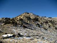 Peak 5978
From the east, a round trip hike to the summit of Peak 5978 is about 3.5 miles with 700 feet of elevation gain.
It is also possible to access Peak 5978 from the west using 4WD roads on the BLM land east of Highway 120, but I have not explored these roads. The main dirt road into here turns off of the highway 3.6 miles from the spot where the highway turns south by the airport. The distances and elevation gain would be about the same from the west side, depending on how close you are able to get in your car.
Red Tape
This area is administered by the BLM, and Marathon has oil leases throughout Oregon Basin; however, this does not prohibit anyone from hiking in this place. Be aware that wells and the gas lines that are on the ground in the open could be dangerous and emit gasses that aren't exactly healthy to breathe, so try and steer clear of these if possible.As noted above, rattlesnakes are the primary danger when hiking this peak during the warmer months, so keep an eye (or two) and an ear out for them as you are walking.
 Typical hiking scenery
External Links
Peak 5978 on Lists of JohnHistorical information on the Loch Katrine Bird Reservation
 Loch Katrine