
-
 8911 Hits
-
 80.49% Score
-
 12 Votes
|
|
Mountain/Rock |
|---|---|
|
|
34.95501°N / 32.99456°E |
|
|
5289 ft / 1612 m |
|
|
Overview
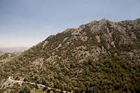
 Adelfoi seen from the south Adelfoi seen from the south |
Adelfoi, sometimes Adelphi (Greek: Αδελφοί) is one of the most beautiful mountains on the island of Cyprus. Even though its summit carries a fire lookout, though there are radio installations on its south-western side summit, even though dirt roads lead to within several hundred metres to its top the mountain and its surroundings are among the most impressive formations on the island. Adelfoi belongs to the Troodos Mountain Range, Cyprus' highest but is located at the eastern outskirts of the higher part of the range. By a saddle it is connected to Madari, a ridge mountain running from west to east. Like all the outlying mountains of the Troodos Range it is composed of limestone, which here is much more solid than anywhere else in the range.
 |  |  |
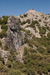
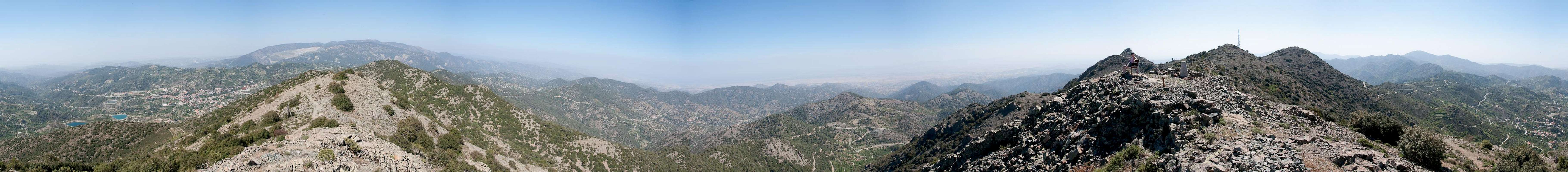
Adelfoi is composed of several formations. There are three main summits, forming a perfectly shaped triangle at the centre of which there is a profound saddle (culmination point of the dirt roads of the area). The main summit carries the only fire lookout on Cyprus, which is open to the public. The south summit is home to the radio antennae mentioned above while all the west summit carries is a bench and a "certified lookout" (our term for lookouts which are advertised by signposts). There the whole of Cyprus is on display, Troodos in the west, as well as the northern and southern coasts. On a fine day the Pentadictylos Range (Kyrenia Range) can be seen as far as the panhandle of the Karpaz Peninsula in the utmost north-east.
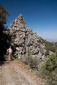 | 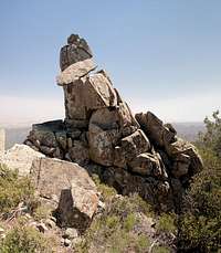 |  |
All around Adelfoi the slopes drop down deeply towards the valleys and in many locations bizarre formations can be found. Even though everything is made up from limestone there are many vertical walls which resemble the lava walls which you can find on many of the Canary Islands. Besides these many a tower or spire can be found but all protected by the dense macchia-like undergrowth. As in many other places of the island, the forestry department has set up a nature trail which surrounds Adelfoi and on which you can witness these formations first hand.
360° Summit Panorama
  |
Getting There
 Adelfoi and Madari Ridge
You can reach the Greek (southern) part of Cyprus from any major airport in Europe. The island has two international airports at Larnaka in the east and Pafos in the south-west. Both airports are connected by a motorway.
While there are several possible trailheads for Adelfoi, the best one is at Doxa si o Theos, a saddle which belongs to the town of Kyperounta. It is located on the eastern outskirts of high Troodos an can be reached as follows:
- From one of the international airports of Southern Cyprus, at Larnaka or Pafos take the motorway (A1 / A6) to Lemesos
- At the exit 27 take E110 to Agros and Chandria
- Look for signs to the locality Spilla from where a short ascending road takes you north to the saddle Doxa si o Theos
Red Tape
 Stellion (Laudakia stellio)
There is no real red tape here. Dirt roads lead to within several hundred metres of the Adelfoi summit but they are only open for forrestry personnel. The fire lookout on the summit is the only one on the island, which is open for hikers / visitors. There is a small picnic area underneath its roof.
Accommodation
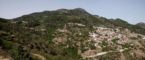 Lagoudera beneath Adelfoi
Accommodation of all kinds is easy to find along the coasts of the island. You can book hotels and apartments from any travel office. Moreover, a lot of British expatriates are living on the island part time. You can get lucky to book one of their winter homes in summer.
Near Adelfoi little accommodation can be found. The closest village is Lagoudera, about 100m underneath and east of the summit. It didn't look like there were any hotels or inns in the village. However, on the south coast on the strip between the cities of Lemesos and Larnaka there is lots of accommodation.
Weather Conditions
Maps & Books
Maps
I must admit that I didn't find any decent maps of the island, maybe caused by the military nervousness mentioned above. I have used the following street map:
- Cyprus / Chipre / Zypern
1:200 000
Freytag & Berndt
ISBN: 978-3-7079-0478-9
Books
Here the situation is different. An excellent guidebook is available from Rother Verlag, both in German and English. It covers the whole island in 50 daytours.
- Zypern (Süd & Nord) / Cyprus (South & North)
Rolf Goetz
Rother Wanderführer / Rother Walking Guide
Rother Verlag
ISBN (German): 978-3-7633-4271-6
ISBN (English): 978-3-7633-4814-5