
-
 7632 Hits
-
 84.27% Score
-
 18 Votes
|
|
Mountain/Rock |
|---|---|
|
|
37.87350°N / 105.4861°W |
|
|
Saguache |
|
|
Hiking |
|
|
Summer, Fall |
|
|
12883 ft / 3927 m |
|
|
Overview

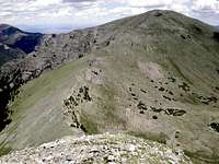
Ascending southern slopes of UN 12883
This big, (seasonally) green mountain rises immediately north of the lovely Medano Lake. The broad, grassy summit is a great place to kick back and enjoy the serenity of the wilderness, while the southern and western slopes are dotted with rugged outcrops of red conglomerate. Another noteworthy characteristic of this peak is the shockingly high timberline on UN 12883. Dense timber seems to never end during the ascent, and krumholtz continues above 12,000 feet. UN 12883 is delightfully removed from easy trail access, though the Medano Lake Trail does bring the peak within reach to those not deterred by a woodsy bushwack followed by a stair-master tundra climb.
Views from the leisurely, grassy top of UN 12883 include the graceful but imposing Crestones to the north in the distance. Blizzardine Peak and Blueberry Peak dominate the view to the immediate north. Greenhorn Mountain is visible to the east, and Badito Cone marks the southern terminous of the Wet Mountains like the dot on an explanation point! The Sand Creek drainage gapes green and deep to the northwest. Just across the valley to the south are dynamite views of neighbors Mount Herard and UN 12925, while the Blanca Group is visible in the southern distance.
Rank: 729th highest peak in Colorado
Prominence: 663 feet
USGS Quad: Medano Pass
Trails Illustrated Map: #138- Sangre De Cristo Mountains
Rank & prominence information source: Lists of John
Getting There
UN 12883 from northern ridge of "Medano Peak"

Southern slopes ascent

Sangre de Cristo Conglomerate
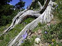
Hairbells on UN 12883
UN 12883 can be accessed via the Medano Lake Trailhead accessed via the Medano Pass Primitive Road. Excellent information about this trailhead, including instructions on Getting There, can be found in SP Member csmcgranahan Medano Lake Trailhead page.
Medano Pass Primitive Road is a rough 4x4 road suitable only for high clearance 4-wheel drive vehicles. Due to the wide variety of conditions on this road, most vehicles will find it necessary to travel the road from east to west. This is why:
The road includes soft sand for about 2 miles, 9 creek crossings that may be deep in late spring, and a rocky roadbed near the summit of the pass. If sand becomes soft during dry times, dropping tire air pressure to about 20 pounds may be necessary. Full tire pressure is required to drive over rocks higher on the pass, so if you do drop pressure, you will need to either 1) have your own air compressor to refill before going higher on the pass, or 2) drive the road from east to west, and reduce pressure after going over the pass but before driving through the soft sand. A free air compressor is available at the western entrance to the road in the national park.
View a NPS map of Great Sand Dunes National Park.
Red Tape

"Medano Peak" from UN 12883
Because the peak lies within the Great Sand Dunes National Park and Preserve, more regulations apply than if visiting the National Forest. Some regulations are somewhat more relaxed in the Preserve than in within the Park boundaries. A few key highlights:
•Fees: It is noteworthy that if approaching from the east on Medano Pass road, no fee is collected for entry.
•Camping: Permits are required for backcountry camping and it is preferred that you camp in designated or at least existing sites. Car camping is permitted only in designated sites (front or back country.) No camping in the krumholtz tree zone or higher.
•Regarding pets: Pets are permitted in the main national park day use areas and in the national preserve as long as they are kept on a leash less than 6 feet long. They are not permitted in the national park backcountry. Please keep the park clean by cleaning up after your pet.
•Note that the Park Service will close Medano Pass Road whenever conditions warrant doing so (fire danger, wet conditions, deep snow pack, etc.)
•Bear-proof storage of food, garbage, toiletries, fish guts, etc., is required.
Camping

Looking to the southwest
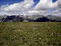
Views from the summit to the north
Camping in the vicinity of Medano Pass Primitive Road is limited to established campsites. These campsites are rustic and dispersed, offering a surprising amount of solitude and privacy. They also contain bear lockers for storage of food, garbage, toiletries and other smelly items that may be of interest to hungry bruins. There are three campsites right near the Medano Lake Trailhead.
For more information about these campsites and for updates on road conditions and closures, visit this National Park Service Website.
Weather & Seasons

Fine views northward
Due to seasonal closures of Madano Pass Road, plus long, trail-less approaches, UN 12883 would be best saved for mid-summer through early fall.