
|
|
Route |
|---|---|
|
|
40.78321°N / 107.18558°W |
|
|
Hiking, Mountaineering, Scrambling |
|
|
Summer, Fall |
|
|
Half a day |
|
|
Class 2-3 |
|
|
Overview
This is the route I used to climb the peak, but it may or may not be the easiest route. Briefly put the route accesses the saddle between Point 9460 and Sugarloaf Mountain at which point the route climbs the west face. The route difficulty varies between class 2 and class 3, depending on variations.
Navigational Warning
Warning: The topo maps available don’t show the roads or trails around this mountain accurately. The closest one that bears resemblance to reality is the Forest Service Map-Routt National Forest, but it is of a small scale. The USGS maps don’t show many of the roads in the areas, but seem to show roads and trails that don’t exist; at least not any more.Getting There
From the junction of Highway 40 and 13 in Craig, turn north on Highway 13. Drive north for about 13 miles to north of mile marker 102 until you see a sign posted for County Road 27. The road is posted for “Forest Service Access” and “Black Mountain”. Drive County Road 27 through private lands for 10 miles which is where you reach the Routt National Forest boundary. The road becomes FR 110. From the Forest Boundary, follow FR 110 for 9.7 miles to FR 116. Turn right on FR 116 and follow it for 6.4 miles to the junction of FR 116 and FR 118. Stay right on FR 116 and follow it somewhere to near its end. There is no trailhead, so there are many places to park. I parked at the drainage not long before the end of the road that comes down from the saddle between Sugarloaf and Point 9460. The reason for choosing this location is that I thought it would be an easy place to find the vehicle on the return trip. Not far west of this parking area, you can park when the road starts descending the hill in order to save some elevation gain.As of August 2010, the road was in good condition and was good for all vehicles.
 Sugarloaf Mountain as seen from the west trailhead.
Route Description
There are several possible locations for starting this climb, but for simplicity, let’s start at the car park/drainage crossing mentioned above.From the trailhead, follow the drainage north, staying on the west side. There were lots of thistles and stinging nettle here, so make sure to wear long pants!
The drainage heads more or less north (with some thick grass/vegetation to get through-but no bushwhacking) until it reaches the saddle between point 9460 and Sugarloaf Mountain. From the saddle, head east up the West Face of Sugarloaf Mountain. There are areas of ankle twisting boulderfields and fallen timber to avoid (or climb over), as well as some steep sections, but there are no major problems.
The top of Sugarloaf Mountain is surrounded by cliffs, but there are many breaks in the cliffs so finding one is not a problem and how difficult the route is will depend on route selection. The route I went up was class 2; the route I came down was a class 3 with some loose rock and a log to climb over. With a bit of route finding, finding a class 2 route will not be a problem.
Once on top of the summit block, enjoy the views, but note that since the summit area is rather large and somewhat flat or rolling, that you must circumvent the entire summit block to take in all the panoramas. The south point, east point and northwest point offer the best views. The south point has an old memorial. There are several bumps on top of the summit block, but the northwest point is the highest and also contains the summit register. After circumventing the summit block, retrace your ascent route.
This route is only three miles round trip, with about 1300 feet elevation gain, but the route is rough and slow-going in places.
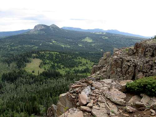 Looking west at the Bears Ears from the south point of Sugarloaf Mountain.