
-
 4750 Hits
-
 82.48% Score
-
 15 Votes
|
|
Mountain/Rock |
|---|---|
|
|
46.70364°N / 11.46067°E |
|
|
Hiking, Skiing |
|
|
Summer, Fall, Winter |
|
|
8435 ft / 2571 m |
|
|
Overview
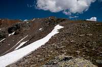
 Blankenhorn / Corno Bianco seen from the south Blankenhorn / Corno Bianco seen from the south |
The Kassian Group of the Sarntal Alps is the central of the three eastern subgroups of that horseshoe shaped range. It is wedged between the Tramin Group, where the highest mountains of the eastern groups can be found and the area around Rittner Horn / Corno Renon and Villanderer Berg / Monte Villandro, which in fact is a giant plateau, covered with some of the biggest pastures of the Alps. The Kassian Group itself consists of about a dozen more or less easy summits, which form standalone groups of two or three mountains, arranged around cirques, which thanks to the poor rock quality in that area can barely distingished as such.
Among these groups two stand out: the highest one around Kassianspitze / Cima San Cassiano and its direct neighbour to the west, the two mountain group of Getrumspitze / Cima Getruna and Blankenhorn / Corno Bianco. On a good day all five mountains can be climbed in one go! The latter group is a broad, curved massif, consisting of two mountains with three summits. The two peaked Getrumspitze is located to the north, one peaked Blankenhorn / Corno Bianco to the south. Both are separated by a barely pronounced saddle, which indeed is so small that it is hard to tell one mountain from the other. However, geology does the trick: while Getrumspitze / Cima Getruna is brightly red, thanks to the amount of porphyry mixwed to its fragile rock, Blankenhorn / Corno Bianco shimmers in bright white colours since here limestone has taken the place of porphyry.
 |  |  |
Both mountains can be climbed by three routes, two of which start at South Tyrol's highest sanctuary the pilgrimage chapel at Latzfonser Kreuz / San Croce di Lazfons:
- Blankenhorn / Corno Bianco east ridge
From Lazfonser Kreuz hike through the Lückl Saddle to Getrumsee / / Lago Gethruna. From here a steep but easy couloir takes you to the broad, plateau-like east ridge of Blankenhorn, from where several hundred of easy metres lead you to the main summit of
- Getrumspitze / Cima Gethruna east ridge From Kassianspitze / Cima San Cassiano a ridge traverse leads to the Getrumspitze / Cima Gethruna east summit. Descend the north-west ridge of Kassianspitze, then ascend the long east ridge of Getrumspitze. To reach the main summit you will have to descend into a saddle precariously. From there a similarly horrible path leads to the main summit of Getrumspitze and on to Blankenhorn / Corno Bianco.
- Blankenhorn / Corno Bianco west ridge The shortest, easiest and most popular route makes use of the cable-car which runs from the village of Reinswald / San Martino to Pichlberg. From there a ridge traverse takes you across Jochplatte to Blankenhorn / Corno Bianco andGetrumspitze / Cima Getruna.
As all summits of the Kassian Group are excellent lookout summits, Blankenhorn / Corno Bianco is no exception. Judge for yourself from the next section.
Summit Panoramas
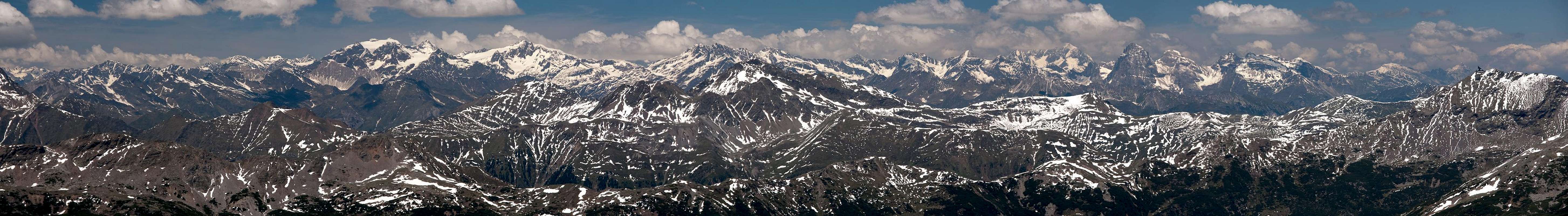
Having shot a 360° panorama from nearby Getrumspitze, on Blankenhorn I concentrated on the three big mountain groups in the north: Ötztal Alps, Stubai Alps, Zillertal Alps. Here are the results: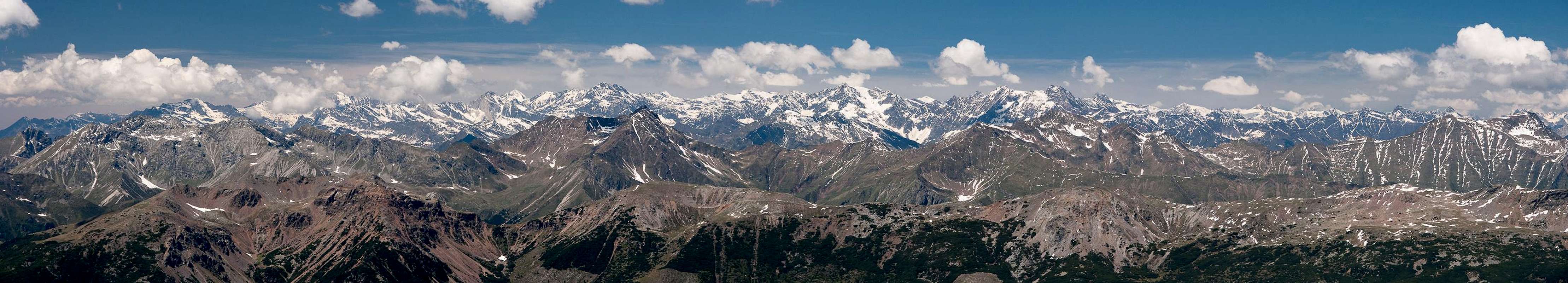  |
 |
 |
Getting There
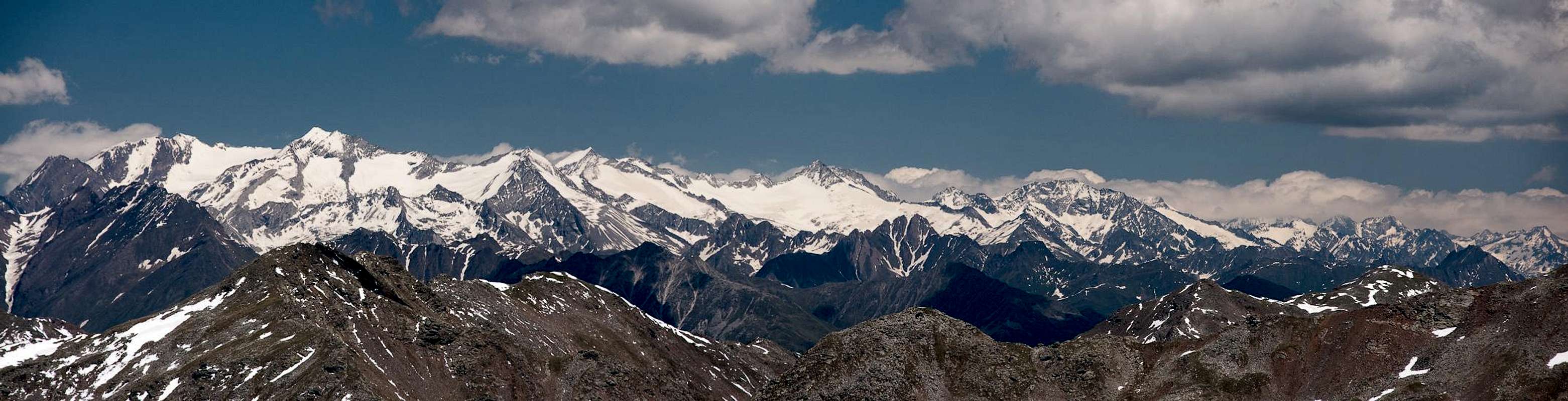
 Getrumspitze Group (left) and Kassianspitze Group (right)
There are two reasonable trailheads for Blankenhorn / Corno Bianco, one at Reinswald / San Martino in Sarntal / Val Sarentino (or rather Durnholztal / Valdurna) and Lazfons in Eisacktal / Valle Isarco. Both trailheads are connected by the pilgrimage trail to the sanctuary at Lazfonser Kreuz / S. Croce di Lazfons
- Reinswald / San Martino trailhead
- Take Brenner Motorway A22 to Bozen / Bolzano
- Drive through the city, following signs to Sarntal / Val Sarentino on SS508
- At Astfeld / Campolasta turn off onto SP137, direction Durnholz / Valdurna
- At Unterreinswald / San Martino Bassa turn onto SP138 to Reinswald / San Martino. Park at the cable-car station.
- Lazfons trailhead
- Take Brenner motorway A22 to the exit Klausen / Chiusa.
- Take SP74 to Feldthurns / Velturno
- Turn left onto SP142 to Lazfons
Red Tape
 Blankenhorn and Getrumspitze
There's no red tape. You might have to cross pasture gates which you are requested to shut behind you.
Accommodation
Eisacktal / Valle Isarco
Bozen / Bolzano
Weather Conditions
Maps & Books
Maps
- Digital Maps
- Regular Maps
- Sarntal/Val Sarentino
Kompass Map WK 056
1:35.000
ISBN: 3-85491-340-0
- Brixen / Bressanone
Kompass Map WK 56
1:50.000
ISBN: 3-85491-063-0
- Bozen / Bolzano
Kompass Map WK 54
1:50.000
ISBN: 3-85491-061-4
- BOLZANO-RENON / BOZEN-RITTEN-TSCHÖGGLBERG
Tabacco Map 034
1:25.000
- MONTE SARENTINI / SARNTALER ALPEN
Tabacco Map 040
1:25.000
- Sarntal/Val Sarentino
Books
- Bozen-Salten-Schlern
Kompass Guidebook WF953
Kompass Verlag
ISBN: 3-85491-406-7
- Rund um Bozen
Helmut Dumler
Rother Verlag
ISBN: 3-7633-4267-2