
|
|
Mountain/Rock |
|---|---|
|
|
46.85767°N / 10.69322°E |
|
|
Otztal Alps |
|
|
Hiking, Scrambling, Via Ferrata |
|
|
Spring, Summer, Fall |
|
|
10371 ft / 3161 m |
|
|
Overview
 Summit View towards the EAST
 Summit View towards the WEST
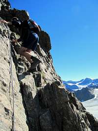 Via Ferrata (I)
 Hintere- and Vordere Karlesspitze as seen from Langtaufener Valley Hintere- and Vordere Karlesspitze as seen from Langtaufener Valley |
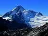
Hintere Karlsspitze is a 3161m high peak located on the Border between Austria (Tirol) and Italy (Sud-Tirol). It is the westernmost peak of the heavy glaciated Weisskamm ridge with its highest point being Wildspitze (3768m).
Hintere Karlsspitze is a beautiful lookout peak with tremendous views all over the Alps. You can see all the way to the Bernina Group in Switzerland, the Otztaler, Samnaun and Silvretta Group in Austria and the Ortles and Reschen in Italy.
The climb of the peak is relaticely short since the Kaunertaler Gletscherstrasse gets you (and your car) up to an elevation of 2750m. From here it is about 1,5 hours to the summit. The route is a simple walk-up until 3000m. From here a nice , relatively short Via Ferrata (Klettersteig, graded I) leads up to the summit. The via Ferrata contains secured lines.
In recent years a cableway was built near the Hintere Karlesspitze. It attracts many daypeople who get up to 3000m in the vicinity of the Karlesspitze. To be honest: It is really annoying to see the masses travel up, take photos and go down again. The good thing is though, almost NOBODY goes up to the summit of Karlesspitze since the Via Ferrata requires some experience. As a result the peak is not often climbed and the chance is quite big to be alone on the summit and the enjoy the fantastic views (way better compared to the cableway views) this mountain offers.
Route
 EAST Face
 Summit Block
 NORTH Face
 Via Ferrata: Close to the Summit
 WEST Face
The route to the summit of Hintere Karlesspitze starts at the ending of the Kauinertaler Gletscherstrasse at an altitude of 2750m.
From here you pass the Gletscherestaurant (on the left side). There is a very well marked path up towards the Karlesjoch. It goes over the rocks and at all time you have the immense Weiss-seeFerner at your left side. The trail goes up to the ending station of the Karles-cableway. So following the cableway leads you in any case to the right point.
There is one split-up on the route: take a left (the right goes up to Wiesjagglskopf).
Reaching the Karlesjoch at about 3050 meters introduces the most beautiful part of the climb: the Via Ferrata.
The via Ferrata is very well 'covered' with secured lines and quite fun to do. It is graded I and is relatively easy and short.
The Via Ferrata ends on the small rocky summit of Hintere Karlesspitze from where the views are great!
Towards the north you will see peaks like Glockturm and Watzespitze. Towards the east: Weisseespitze with it's great glacier. Towards the south: Weisskugel Towards the west: Silvretta and Reschensee.
Note:
The path that leads from Karlesjoch towards Wiesjagglskopf is CLOSED! The marked path is completely covered with loose stones and there is a big danger of falling rocks! If you attempt to climb Wiesjagglskopf: Go down the same way you came up and take the path up in the vicinity of the Gletcherrestaurant. This will take somewhat longer but is much more safe!
Surrounding Summits:
 |
 |
 |
 |
 |
 |
How to get there
 Summit Pano from the Summit: in the far left the Bernina Group, in the far right the Fluchthorn. In front the Langtaufener Valley
Major Car Routes:
Füssen/Garmisch-Fernpaß-Imst-Landeck-Prutz-Kaunertal
Garmisch-Zirl-Imst-Landeck-Prutz-Kaunertal
Arlberg-Landeck-Prutz-Kaunertal
Reschenpaß-Nauders-Pfunds-Prutz-Kaunertal
Brennerpaß-Innsbruck-Imst-Landeck-Prutz-Kaunertal
A routeplanner can be found HERE
For the Kaunertaler Gletscherstrasse you have to pay an entrance fee of 20 euro's!
Camping
Aktiv Camping Prutz:Internet Site
Camping Kaunertal:
+43 (0)5475-316
+43 (0)5475-31665
(no Internet Site)
Weather & Links
Weather Forecast KaunertalLive Webcams
Snow Report
Books:
Leichte 3000er: 99 Touren mit Weg
Dieter Seibert
ISBN-10: 3765436771