
-
 18392 Hits
-
 88.19% Score
-
 26 Votes
|
|
Mountain/Rock |
|---|---|
|
|
38.83500°N / 105.228°W |
|
|
Teller |
|
|
Hiking, Scrambling |
|
|
Summer, Fall, Winter |
|
|
9044 ft / 2757 m |
|
|
Overview
 My party on the summit
Dome Rock is one of those lower-elevation Colorado peaks that could convert any of those “I only do 12ers or higher” types to the pursuit of lower mountains. The granite outcrop rises above a sea of forest, rocky crags and valleys in habitat sheltering a herd of Bighorn Sheep. Views from the top are wide open and expansive, taking in a variety of mountain ranges and even the back side of Pikes Peak.
However, it is the nearby views that are the most captivating. Close-up UN 9112 tempts the visitor to find a route to its summit. Described in a trip report on SummitPost as a “mini Yosemite,” the Dome Rock area is a neat treat of spires, domes and outcrops of Pikes Peak granite, cut by a pair of streams.
Reaching the summit of Dome Rock requires a moderately long (approximately 10-11 mile) hike capped by an all-too-short scramble on grippy granite to a sloping domed summit. The granite of the dome is etched by drainage runnels. The wind rushing over the dome, combined with the views, are sure to take your breath away.
Colorado Rank: 2903rd highest peak
Prominence: 334 feet
USGS Quad: Cripple Creek North
Rank & Prominence Info: Lists of John
Getting There
 Looking down the summit runnels
 Approaching the friction section
 Looking down from northeast side
 Dome Rock from Northeast
Driving Directions
From Hwy 24 in Divide, Colorado, take Highway 67 south for 5.8 miles to Four Mile Road / County Road 61, which veers gently to the right. Pass a fish hatchery on your left. Follow this road for 2 miles, and see a Division of Wildlife sign on the right announcing you have arrived at Dome Rock. Park in the lower lot.
State Wildlife Area Trail Map (in PDF)
Route Information
Either major trail system from the main parking area will lead the hiker to a short off-trail to the base of Dome Rock. The northern 4 Mile Creek Trail sees less elevation variation, but requires several un-bridged stream crossings which can be tricky in higher water. The Willow Creek to Spring Creek southern route has many fewer stream crossings but requires an ascent to a meadow at about 9,500 feet before descending into the Spring Creek drainage. Rock climbing in the Dome Rock State Natural Area is prohibited. The trick to obtaining the summit of Dome Rock without protection is locating the ramp and crack system on the northeast side of the outcrop. The crux of the route, for most hikers, will be a low-angle friction segment which should not be attempted in wet conditions. Out of respect for the silver-haired Mountain Jedi who showed me the way to this summit, I will not post a detailed route description or route.
 Upper route illustration
Red Tape
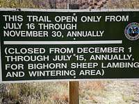 Seasonal Closure Info
 About the Preserve
Purchased in the late 1970s by The Nature Conservancy, the Dome Rock preserve is considered a cooperative project between the Conservancy and Colorado state agencies. Dome Rock is managed by the Colorado Division of Parks and Outdoor Recreation in cooperation with the Colorado Division of Wildlife (DOW).
The area immediately surrounding Dome Rock in the southwest portion of the preserve is closed more of the year than it is open to protect a population of Big Horn Sheep. No dogs are allowed and travel is permitted by foot or on horseback only (no mountain bikes, no motorized vehicles).
Leave your climbing gear at home! Note that per this website PDF, rock climbing is prohibited.
Camping
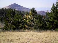 Mount Pisgah from meadow
 Fourmile Creek Valley
Mueller State Park
Winter: 17 First-Come First-Serve electrical sites. $20/night. Summer: 132 campsites, including electrical RV sites and walk-in tent-only sites. $22/night Summer Reservations 1-800-678-2267 or 303-470-1144. To learn more, visit this State Park website: http://parks.state.co.us/Parks/Mueller/Camping/Pages/MuellerCamping.aspx
Crags Campground
The National Forest Service’s Crags Campground sits on the western slope of Pikes Peak and provides a logical campsite option just across Hwy 67 for anyone visiting Dome Rock.
Weather & Seasons
 UN 9112 tempts the hiker
 Relaxing on the Summit
 Drainage channels
 Runnels in Granite
First, as noted in the Red Tape section, Dome Rock is closed much of the year to protect a population of Bighorn Sheep.
Autumn is the ideal time to visit Dome Rock. Not only is the preserve open in the fall, but the leaves of the aspen, willow and even narrow-leaf cottonwood are a stunning golden, the air is cool and crisp and any stream crossings encountered should be more manageable prior to the first snowfall.
For safety, Dome Rock should not be attempted in wet, snowy or icy conditions. The low-angle friction sections of the dome climb would be especially treacherous if icy or wet.
 South from the summit
bradk - Jul 2, 2011 11:23 am - Hasn't voted
Climbing ProhibitedDome Rock is within the Dome Rock State Wildlife Area and is a Colorado Natural Area. I am the volunteer steward for the Natural Area. Rock climbing is prohibited. In view of this, please modify the post. Thank you!
Sarah Simon - Jul 4, 2011 3:32 pm - Hasn't voted
Re: Climbing ProhibitedThanks for the note.