

|
|
Area/Range |
|---|---|
|
|
47.12495°N / 25.18575°E |
|
|
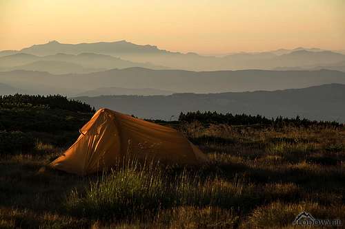
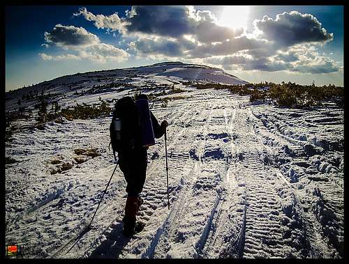
Hiking, Skiing |
|
|
Spring, Summer, Fall, Winter |
|
|
6900 ft / 2103 m |
|
|
LukZem Videos
|
Video
Best photos of the Călimani taken in 2011
|
Overview
|
||||||||||||||||||||||||||||||||||||
|
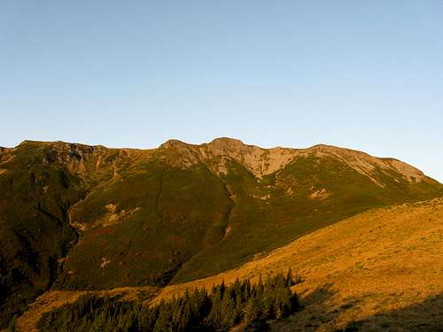
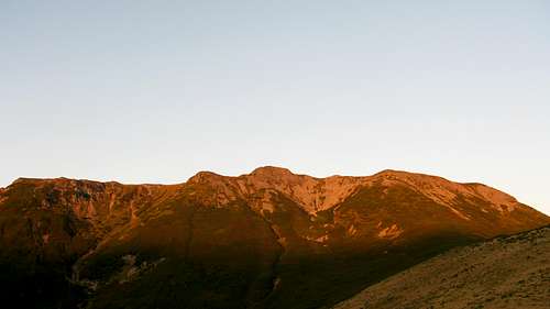
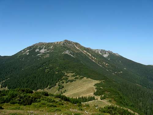
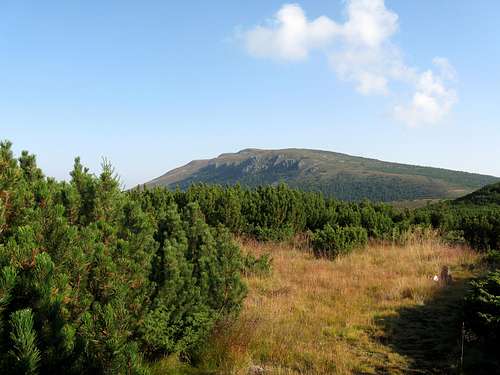
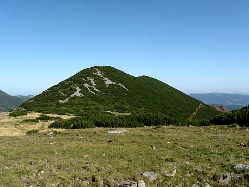
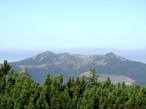
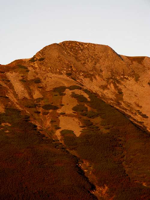
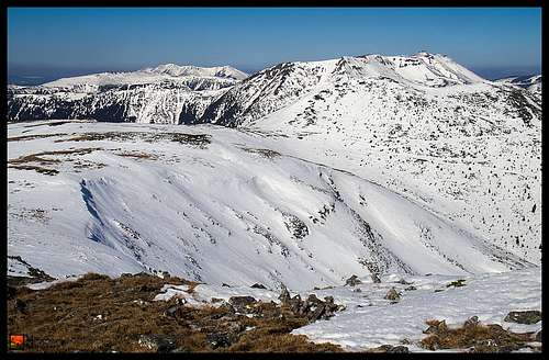
The Călimani (or Căliman) Mountains are situated in the Eastern Carpathians and cover an area of about 2000 sq km, stretching east-west for about fifty kilometers. For most of the second Millennium A.D. the range was part of a broad, mountainous borderland between the Hungarian Kingdom/Principality of Transylvania (an ethnically mixed country) and the predominantly Romanian and Ukrainian-speaking lands of Bucovina and the principality of Moldavia. It is no wonder that among the peaks of the Căliman/Kelemen one can find both Negoiul Unguresc/Magyar Negoj and Negoiul Românesc/Román Negoj (the italicized words translate as Hungarian and Romanian, respectively). On the south the Călimani Mountains are bounded by the Mureş/Maros River, which separates them from the Gurghiu Mountains; and on the southeast by the Sec and Topliţa creeks, beyond which the Giurgeu Mountains lie. The northern limits are drawn by the valley of the Transylvanian Bistriţa, which sets the massif apart from the Bârgau Mountains, and the Dorna valley, which divides it from the Suhard Mountains. Towards the west the Călimani Mountains slope gently into the Transylvanian Basin, while their eastern limits make a transition towards the Bistriţei Mountains, which sit beyond the pass of Păltiniş and the basin of Bilbor. The name of the range was first recorded (in Latin) as early as 1228 as Alpes Clementis and may refer to the fact that the mountains - compared to the nearby Rodnei range rising on the northern horizon - have gentler slopes and a milder climate.  The heart of the former volcano The heart of the former volcanoThe Călimani is the youngest mountain range in Romania and the highest range in the Carpathians made of volcanic rocks. Its eastern part is dominated by the largest inactive crater in all of Europe, over ten kilometers in diameter. The mountains came into being as a stratovolcano or a 'composite volcano', which means that they formed as a result of successive eruptions during an extended period of time, through alternating layers of solidified lava and volcanic ash. Volcanic activity began 7 Ma (7 million years ago) and reached its climax around 5 Ma. This first phase of an active volcano was followed by a period of volcanic standstill, increased erosion and deposition. The second phase occurred over 2 Ma. The inactive volcano with its partially emptied magma chamber was no longer able to hold the weight of the entire cone. Great tension caused by differences in pressure and weight created ring fractures. The third phase took place in the Pleistocene (Ice Age), when a large part of the volcanic cone collapsed following the ring of fractures. The result was a caldera. Rains, rivers, wind and temperature variations have modified the landscape ever since. Inside the Călimani caldera rise a few secondary cones, such as Pietricelul, Haitei and the most shapely Negoiul Românesc at 1889 m, whose bowels contained a unique phenomenon that can hardly be seen elsewhere in Europe - volcanic caves. Unfortunately, the mountain along with its cave system was devastated by an open-cast sulphur mine opened in the 1970s. 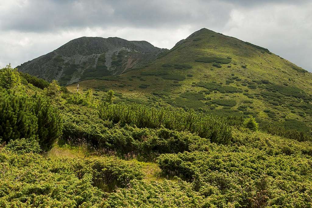 Pietrosul at 2103 m seen from the north - photo by Tomek Lodowy Pietrosul at 2103 m seen from the north - photo by Tomek LodowyThe most interesting part of the Călimani Mountains, adorned with the highest summits, is the rim of the huge caldera, today looking like a horseshoe with an open north end. This is the only spot within the Carpathian volcanic belt which bears traces of glaciation. The highest peak called Pietrosul (Pietrosu)/Pietrosz (Nagy-Köves), reaching an elevation of 2103 m, and the second highest summit, Negoiul Unguresc at 2081 m, form a massive crest, which stands out from the background of forest (Călimani woodland is dominated by spruce, over half of which is old-growth) and higher up bushes of dwarf pine and juniper, featuring an alpine zone with short grasses and dwarf shrubs such as Rhododendron kotschyi. Ten kilometers west of Pietrosul, near the center of the main ridge, sits the second highest group of peaks dominated by Bistricioru/Kis-Beszterce csúcs with around 390 m of prominence, falling just ten meters short of the 2000 m mark. The western part of the range is much lower and less popular with hikers and holidaymakers except a couple of places, such as Colibița Dam in the northwest and the God's Seat ('Scaunul Domnului' in Romanian, 'Istenszéke' in Hungarian) at 1381 m in the southwest chunk of the mountains. The latter, sitting several kilometers away from the main ridge, is shaped like a table mountain whose cliffs tower over the Mureş Valley. The summit offers a fine panorama of the main ridge in good weather. The table below lists the highest summits in the Călimani Mountains.
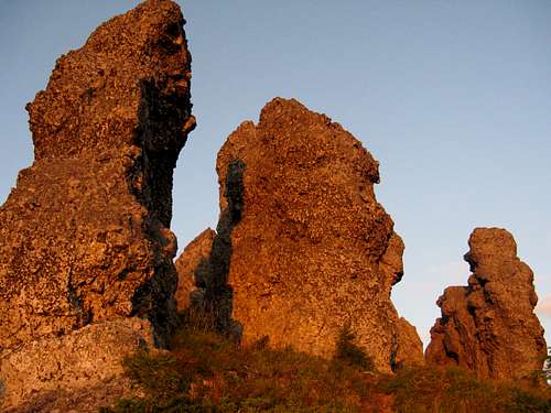
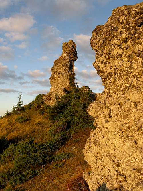
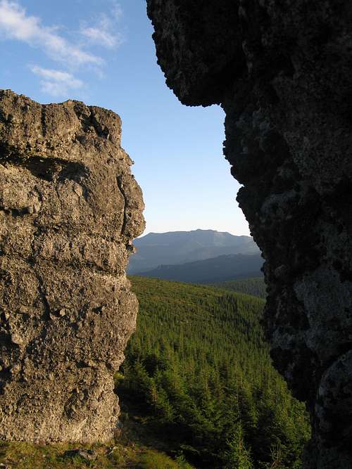
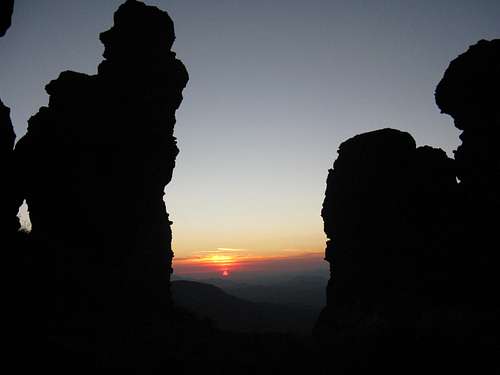
The Călimani Mountains teem with picturesque, bizarre rock formations chiseled out of andesite by erosion. Some of them have been designated geological reserves, e.g. Pietrele Roşii, Tihu, Rusca, Tămaulău and the most spectacular group of rocks known as the Twelve Apostles. These fascinating rocks, sitting on the western rim of the Călimani caldera, make up an impressive gallery of figures, 8-12 m tall, among them the Marshall, Lizard and Dragons. The place does have some special, almost magical charm.
|
Getting There


Nearest airports
- Cluj-Napoca - about 170 km away, 3 hr by car, over 5 hr by train
- Suceava - over 130 km, 2 hr 15 min by car, 3 hr by train
- Târgu Mureş - over 80 km, over 1 hr 15 min by car, less than 3 hr if you take a through train
German Railways - all Europe covered
Main access points
- From the South (road E578 aka DN15 and railway up the Mureş/Maros Valley): Răstoliţa or Lunca Bradului - trails to Bistricioru/Pietrosu; Stânceni or Topliţa - trails towards the south rim of the Călimani caldera; Gălăoaia on road E578 / Borzia (train stop just outside Gălăoaia) - about 7 km south of the God's Seat
- From the North (road E58 aka DN17 here): Gura Haitii (13.5 km by paved road from Șaru Dornei on road DJ174, 24 km from Vatra Dornei on road E58/railroad) at the northeast end of the caldera, 10 km NE of Pietrosu; Dornişoara (15 km by dirt road from Poiana Stampei on road E58) - yellow dot trail to Pietrosu
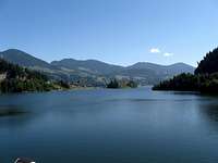
- From the West: Colibiţa by the lake on the Bistrița (21 km by paved road from Secu on road E58, 10 km by dirt road from Mureșenii Bârgăului) - trails to the Bistricioru group
Maps & Books


- 1:60,000 by DIMAP: paper or digital
- 1:70,000 by Munții Noștri - (it covers most of the mountains, except their westernmost swath)
- The Mountains of Romania by James Roberts
Red Tape & Camping
|
|||
Much of the eastern part of the Călimani Mountains has been declared a National Park, where:
|
|||
|


Accommodation


- A few dozen guesthouses and hotels in the villages on the fringe of the mountains and around Colibița Lake
- No mountain huts in the mountains, still a number of shelters and shepherd huts, where one can bed down
- Weather Station lodge on the top of Raţitiş can put up 10-20 hikers, only with previous approval.
- The unmanned refuge by Iezer Lake for 6-10 hikers is open only in the presence of the rescue team (no regular duty - closed during LukZem's August 2011 visit)
Weather, Hazards & Rescue

- Salvamont (Romanian mountain rescue) emergency number is 0725 826 668 or 0-salvamont
Alternatively, you can use 112 (the European emergency number).
- Report of a fatal avalanche (in Romanian)
- In 2011 the rescuers were on duty at the weather station on Răţitiş at weekends.
- Other potential hazards: sheepdogs in the less frequented areas (although the EU regulations have pushed many shepherds out of work recently), bears (fortunately not as big a problem as in the Bucegi or Harghita mountains), vipers (a bite shouldn't kill you unless you're allergic but serum will be necessary).
 |
 |
 |
More Links, Pix & Old Story
- Video: Iezer Lake - Pietrosu - Rusca; the God's Seat
- TR of an ascent of Bistricioru
- Țara Dornelor Ecotourism Association
 |
 |
yatsek - Oct 16, 2011 1:12 pm - Voted 10/10
My Linguistic SpeculationsThe name of these mountains is one of the classic Carpathian mysteries. "Kelemen" translates as clement. Such an adjective seems to fit these mountains very well, especially if one juxtaposes them with the nearby Rodnei or the Marmarosh mountains further to the north. On the other hand, it seems likely that the name was a reference to a person's name, which must have been quite popular a thousand years ago, in the early years of the Hungarian Kingdom. There were several popes named Clement in the 11th and 12th centuries A.D., and even though the word "kelemen" is no longer used by modern Hungarian as an adjective, "Kelemen" has survived as a common Hungarian surname.
LukZem - Oct 17, 2011 3:08 am - Hasn't voted
Re: My Linguistic SpeculationsVery interesting speculations. Maybe, Peter should know more...
peterbud - Oct 17, 2011 3:07 pm - Voted 10/10
Re: My Linguistic SpeculationsI can only confirm that it's a surname that is used, and that its meaning has vanished. Unfortunately I have no time for investigating further now.
peterbud - Oct 17, 2011 3:50 pm - Voted 10/10
Re: My Linguistic SpeculationsOK, I couldn't resist. The first written mentioning is dated back to 1228: "alpes Clementis". So the name is old, but not older than the presence of Cristianity in the area (~11th century).
yatsek - Oct 17, 2011 5:17 pm - Voted 10/10
Re: My Linguistic SpeculationsRe: "OK, I couldn't resist." :-) Thanks - this is what we wanted. :D
dand - Jun 15, 2017 1:03 pm - Hasn't voted
Train travel in RomaniaHi! I'm from Romania and I travel a lot around the country. If you wanna travel around, best way is the train way. You can find train's time list here http://mersul-trenurilor.net . I always using this application in my trip.
yatsek - Jun 18, 2017 6:24 pm - Voted 10/10
Re: Train travel in RomaniaThanks. The link does look better than the old one.
LukZem - Jun 20, 2017 12:42 pm - Hasn't voted
Re: Train travel in RomaniaThanks for your hint. I am looking forward to next week´s travel by train from Cluj to Lotru (via Turnu Rosu pass:)