1 - Overview
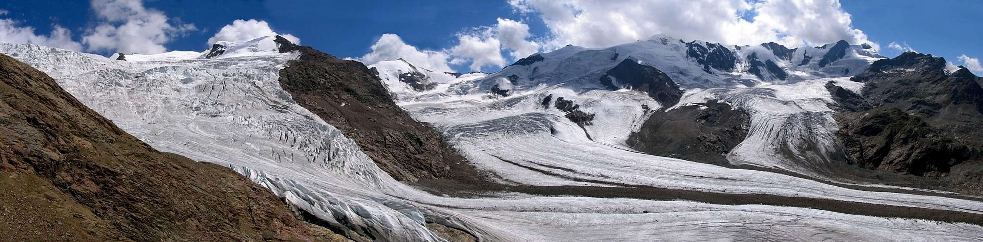
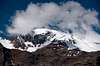
![Pano of the summit around Forni Glacier.]() Forni Glacier and surrounding mountains seen from Cevedale Forni Glacier and surrounding mountains seen from Cevedale |
In the central part of the
Ortler / Ortles - Cevedale Group boundaries are hard to define. All ridges rise up to the culmination point,
Ortler / Ortles itself and the separating saddles are often only slightly pronounced. Due to this there is a lot of confusion about the subgroups of the bigger range. While along its outskirts the grouping is obvious the closer you get to the centre the more ambiguous it gets. As far as I know the most thorough grouping has been done by the German Alpine club and I'll follow it here. Here the south-western part of the
Ortler / Ortles Group is considered one subgroup, stretchin from
Ponte di Legno in the south-west up towards
Cevedale in the north. Thus the subgroup contains some of the most important mountains of the range, which is reflected in the name:
Cevedale - Vioz - San Matteo Group.
Let's start with the boundaries:
- The northernmost point of the group is Langenferner Joch / Passo del Cevedale, the pass in which Rifugio Cassati is located.
- From here the western boundary follows Val di Cedec and Val dei Forni to Santa Caterina di Valfurva.
- It turns south through Valle di Gavia, across Gavia Pass, and through Valle delle Messi to Ponte di Legno.
- Here it turns eastward across Passo Tonale to Fucine / Ossana.
- Now turning back north it Follows Valle di Peio, Val de Male and Val Venezia to Furkelscharte / Forcella di Furcola.
- The northern boundary is formed by the east and west ridges of Zufallspitze / Cima Cevedale.
Almost all of the mountains of the subgroup are located on two ridges, which together appear to be S-shaped.
Valle del Monte separates the ridges. The northern main ridge runs from
Cevedale southward to
Monte Vioz, turns west, passing the mighty
Ghiacciaio dei Forni (Forni Glacier) to
Punta San Matteo, from where it reaches its endpoint,
Corno dei Tre Signori, the westernmost mountain of the group. The south ridge first runs south-eastward along the
Ercavallo Crest towards
Forcellina di Montozzo from where it heads north-westward across
Monte Redival towards
Peio. The mountains on the south ridge are far less important than the northern ones.
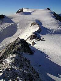
The most obvious feature of the north ridge is the giant
Forni Glacier, which accompanies the ridge for two thirds of its length. It is the largest consecutive glacier of the
Ortler / Ortles Group and is cradled in the giant cirque with the north ridge forms around it. The mountains on the crest easily exceed 3000m, most of them easily exceeding 3500m. The only hiking summit of the group is
Monte Vioz, located right in the centre of the ridge, at the north-eastern end of the
Forni Glacier. All other mountains are serious mountaineering objectives most often requiring glacier traverses. The mountains are formed from Quartz-Phyllite, which separates them geologically from the main Dolomite mountains of the
Ortler / Ortles Main Ridge. Consequently summits and crests are much smoother, also thanks to the erosion of the big glaciers of the group.
The traverse of the mountains of the cirque, the 13 summits tour, is a famous mountaineering feat. It starts at
Passo di Gavia and ends at
Langenferner Joch / Passo del Cevedale, climbing all important summits of the main ridge. The traverse takes three days and makes use of
Bivacco Meneghello in
Passo dei Orsi,
Rifugio Mantovia al Vioz and
Rifugio Cassati for overnight accommodation. The most diffucult sections are UIAA II and will be found on the traverse from
Bicacco Maneghello to
Monte Vioz during the second day.
Unlike elsewhere in the
Ortler / Ortles Group the mountains carry only Italian names, the only exception being
Zufallspitze / Cima Cevedale at the northernmost end, where the German Italian language border runs in west-east direction. However, the region belonged to three different political entities for much of the time, expressed by the cornerstone mountain
Corno dei Tre Signori (Peak of three Rulers), where the borders of the
Republic of Venice met the
Archdiocese of Trento and the
Swiss Canton of Graubünden / Grisons. Today the area is completely on Italian ground but still the mountain separates three provinces:
Trento,
Brescia and
Sondrio. Also, the border between
Lombardia and
Trentino - Alto Adige / Südtirol runs across the main ridge.
2 - The Cevedale - Vioz - San Matteo Group on SP
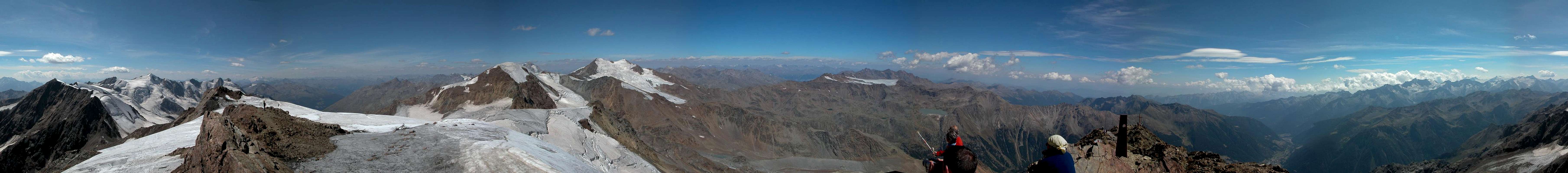
360° Summit Panorama Monte Vioz |
- Cevedale - Vioz - San Matteo Group
3 - The Summits
Google Terrain map of the Cevedale - Vioz - San Matteo Group. Zoom in to see the mountain names.
3.1 - Main Ridge
Monte Cevedale (3769m)
Zufallspitze / Cima Cevedale (3757m, 3700m)
Monte Pasquale (3553m)
Monte Rosole (3513m)
Palon de la Mare (3703m)
Monte Vioz (3645m)
Dente Del Vioz (2905m)
Cima Vioz (2504m)
Punta Taviela (3612m)
Cima di Peio (3549m)
Rocca Santa Caterina (3529m)
Punta Cadini (3524m)
Cima Frattasecca (2738m)
Cima Castello (3162m)
Monte Giumella (3584m)
Le Mandriole (2930m)
I Mughi (Corni di Morto) (3011m, 3118m, 3251m, 3355m)
Punta San Matteo (3678m)
Monte Mantello (3517m)
Cima Dossegu (3560m)
Punta Pedranzini (3599m)
Pizzo Tresero (3594m)
Punta Segnale (3132m)
Sasso Cerena (3037m)
Cima San Giacomo (3281m)
Cima Villacorna (3447m)
Pizzo di Val Umbrina (3225m)
Cima di Val Umbrina (3222m)
Punta della Sforzellina (3100m)
Corno dei Tre Signori (3360m)
3.2 - South Ridge
Monte Gaviola (3025m)
Torre dei Camosci (3164m)
Cima di Caione (3140m)
Cima delle Graole (2861m)
Punta di Ercavalio (3068m)
Punta di Montozzo (2863m)
Torrione d'Albiolo (2969m)
Monte Tonale Orientale (2696m)
Cima Cassaiole (2779m)
Monte Tonale Occidentale (2694m)
Cima di Cadi (2606m)
Cima Bleis (2628m)
Monte Redival (2973m)
Monte Mezzolo (2663m)
Monte Palu (2835m)
Cima Forzellina (2829m)
Cima Boai (2685m)
Palon Val Comasine (2449m)4 - Getting There
- Sulden / Solda
- Take Brenner Motorway A12 to Bozen Süd / Bolzano Sud
- Switch to SS38 through Vinschgau / Val Venosta.
- For the Martell / Martello trailheads turn south onto SP2 at Latsch / Laces
- For Sulden / Solda drive through Spondinig / Spondigna and Stilfs / Stelvio.
- Shortly afterwards turn south on a side road to Sulden / Solda
- Val dei Forni
- Take SS38 northwards to Bormio
- Turn onto SS300 south to Santa Caterina di Valfurva
- Turn east into Val dei Forni
- Take SS42 to Ponte di Legno
- Turn north onto SS300 to Santa Caterina di Valfurva
- Turn east into Val dei Forni
- Val di Peio
- Take Brenner Motorway A22 to the exit San Michele all'Adige
- Take SS43 to Tasullo
- Take SS42 to Ossana, then switch to SP87 to Peio
5 - Accommodation
6 - Red Tape
The Cevedale - Vioz - San Matteo Group belongs to Nationalpark Stilfser Joch / Parco Nazionale dello Stelvio. See the following link for more information:
7 - Weather Conditions
8 - Maps & Books
8.1 - Maps
Digital Maps
Regular Maps
- Nationalpark Stilfserjoch / Parco Nazionale dello Stelvio
Kompass Map WK072
1:50000
ISBN: 3-85491-391-5
- Vinschgau / Val Venosta
Kompass Map WK52
1:50000
ISBN: 978-3-85491-058-9
- ORTLES-CEVEDALE / ORTLERGEBIET
Tabacco Map 008
1:25000
ISBN: 978-8883150081
8.2 - Books
- Vinschgau
Rother Wanderführer
Rother Verlag
ISBN: 978-3-7633-4204-1
- Vinschgau / Ortlergruppe
Kompass Wanderbuch 950
Kompass Verlag
ISBN: 3-87051-404-3
- Ortleralpen
P. Holl
Alpenvereinsführer
Rother Verlag
ISBN: 3-7633-1313-3

 8676 Hits
 86.37% Score
 22 Votes
 Forni Glacier and surrounding mountains seen from Cevedale