
-
 5095 Hits
-
 78.27% Score
-
 9 Votes
|
|
Mountain/Rock |
|---|---|
|
|
27.90380°N / 15.62681°W |
|
|
Download GPX » View Route on Map |
|
|
Hiking |
|
|
Spring, Summer, Fall, Winter |
|
|
4314 ft / 1315 m |
|
|
Overview
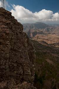
 Morro de la Hierba de Huerto Morro de la Hierba de Huerto |
Gran Canaria is an almost circular island whith a high plateau at its centre, the Cumbre Central, which almost reaches 2000m. From this plateau several ridges run out to the wst and south separating wild barrancos from huge cauldron like craters. The biggest and most famous of these are Caldera de Tejeda in the west and Caldera de Tirajana in the south-east. In between, between the Pajonales- and Pilancones-Ridges you will find Gran Canarias weekend resort, a dry plateau on which a number of water reservoirs have been created which now are used for recreation activities. And one of these, Embalse de Chira is overshadowed by the big bulk of Morro de la Hieba de Huerto.
 |  |  |
It is a morro, a flat topped mountain, a ridge in itself which forms the western boandary of Pilancones Natural Park. From the reservoir, an easy trail (dirt road and path) leads to its summit in little more than one hour and moreover you'll find a radio installation on its very top. However, there is another, far longer route to the mountain, which surprises with its harsh beauty and the solitude you encounter in a region otherwise buzzing with tourist activity. This route starts at Cruz Grande, one of the most important trailheads of the island, follows a scenic ridge but then avoids the morro, instead following its east face in a very long traverse. Finally, abarely visible path leads up to the plateau through a lonesome valley, topping out right opposite the normal route. 500m of road hike take you to the summit up front.
 |  |  |
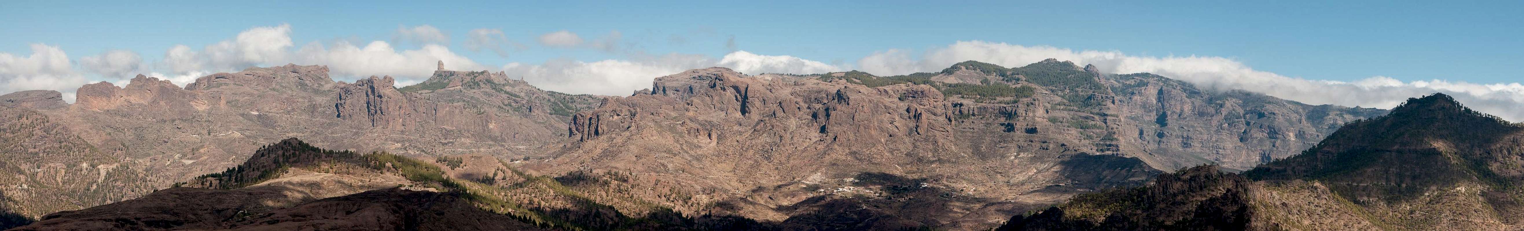
From the summit the west and north faces drop for sme 200m offering dizzying views onto the plateau with the lakes and across Pilancones park. In addition, the morro is a wonderful vantage point to take in the Cumbre Central, complete with the landmarks Los Canadores, Montaña del Asserador, Roque Nublo and Pico de las Nieves, separated by the Ayacata Valley.
Summit View Cumbre Central
  |
Getting There
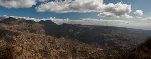 Pilancones Natural Park seen from the Morro
Gran Canaria can be reached from any major European airport. Usually charter carriers fly there but the spanish airline Iberia has also regular flights. The airport is on the eastern coast of the island, far away from the tourist centres in the south.
Trailheads for Morro de la Hierba de Huerto are at Chira or Cruz Grande.
- From the south
- From Maspalomas take GC60 through Fataga and San Bartolome to the saddle Cruz Grande. Here the long but scenic route starts.
- From the saddle stay on GC60 through La Plata after which you turn left onto GC604 to Chira and Embalse de Chira.
- From the north
- From Telde take GC131 which turns into GC130, direction Pico de la Nieve. The road will hit GC150 right at Gran Canaria's highpoint.
- Stay on GC150 for a few metres, then turn onto GC600 to Ayacata.
- Turn left onto GC60, direction San Bartolome.
- For Chira turn right onto GC604, for Cruz Grande stay on GC60.
Red Tape
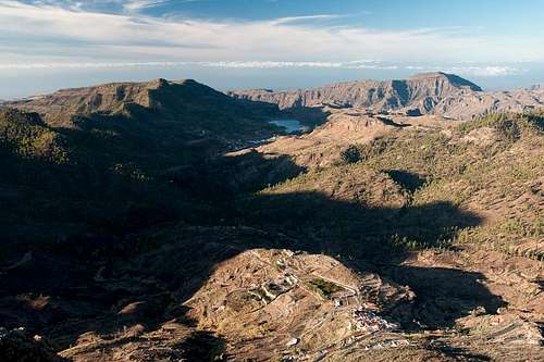 Morro de la Hierba Huerto and Montaña de Tauro
Morro de la Hierba de Hureto is located in Parque Natural de Pilancones. Even thogh there is a radio station on top respect the usual restrictions for the park. Also, fire danger is often very high in the area. The Canary Pines, though protected by a thick bark, drop lots of long dry needles, which weave a carpet underneath the trees, which can easily be kindled into a forest fire. Gran Canaria has its (recent) history of these fires.
Accommodation
Gran Canaria has a lot of options for accommodation. Most visitors book hotel rooms from their travel offices or over the internet. However, you will most certainly end up in the ugly tourist centres along the south coast. Therefore a much better solution is to rent a holiday home, most often a rural finca. This can also be done by travel office or internet.Camping is a bit of an issue on all the Canary Island. There are designated camping zones but getting a place often involves some bureaucracy. The closest campground is at Embalse de Chira to the north-west of the mountain. Wild camping is not permitted anywhere on the island.
Weather Conditions
The following table gives a rough general overview over the weather on Gran Canaria, at sea level.| Month | Jan | Feb | Mar | Apr | May | Jun | Jul | Aug | Sep | Oct | Nov | Dec |
| Avg. day temp.[°C / °F] | 21 / 70 | 21 / 70 | 22 / 72 | 22 / 72 | 22 / 72 | 23 / 73 | 24 / 75 | 25 / 77 | 25 / 77 | 25 / 77 | 24 / 75 | 22 / 72 |
| Avg. night temp.[°C / °F] | 16 / 61 | 16 / 61 | 16 / 61 | 17 / 63 | 16 / 61 | 17 / 63 | 18 / 64 | 20 / 68 | 20 / 68 | 18 / 64 | 18 / 64 | 17 / 63 |
| Water temp.[°C / °F] | 19 / 66 | 18 / 64 | 19 / 66 | 19 / 66 | 19 / 66 | 20 / 68 | 22 / 72 | 23 / 73 | 23 / 73 | 23 / 73 | 21 / 70 | 20 / 68 |
| Rainy days | 4 | 3 | 2 | 2 | 1 | 1 | 1 | 1 | 1 | 3 | 3 | 3 |
The Canarian Islands (as well as Madeira) are located in the trade wind zone. You almost always encounter northeastern winds which carry a lot of humid air. Being forced to climb to higher altitudes this moisture condenses into clouds. This in return means that most of the time the northeastern part of the islands is covered in clouds from altitudes of 1000m through 1500m.
The mountainous region in the centre of the island is of the same alltitude and higher and thus stops the clouds. While the northern parts of the islands can be foggy and rainy the southern parts most often are sunny and hot. On Gran Canaria the north-eastern part of the island collects almost all moisture. However, unlike on the other Canary Islands no cloud forest remains. The laurisilva fell victim to the agricultural development of the island.
Maps & Books
Regular Maps
- Gran Canaria
Kompass Map WK237
Kompass Verlag
1:50000
ISBN 3-85491-114-9
- Gran Canaria North
Public Press Map 442
1:50000
ISBN: 978-3-89920-442-1
- Gran Canaria South
Public Press Map 443
1:50000
ISBN: 978-3-89920-443-8
Digital Maps
Kompass is the only company known to me which offers GPS digital Maps. In addition for those of you with Garmin GPS receivers there is a map source map set of all Canary islands out there.
- Gran Canaria
Kompass GPS4237
Kompass Verlag
ISBN 978-3-85491-219-4
- Islas Canarias
Map Source custom map
By Manfred Pepper
downloadable zip-file
Books
My recommendation is a guidebook by Rother Verlag, available in English and German. The book is an excellent hiking guide covering all the interesting areas of the island. Since it comes with small maps for each excursion it might even be used without a map to support them.
- Gran Canaria
Izabella Gawin
Rother Verlag
ISBN 978-3-7633-4816-9 (English)
ISBN 978-3-7633-4000-2 (German)