
-
 3969 Hits
-
 77.48% Score
-
 8 Votes
|
|
Mountain/Rock |
|---|---|
|
|
27.96567°N / 15.62084°W |
|
|
Trad Climbing, Sport Climbing, Big Wall, Scrambling |
|
|
Spring, Summer, Fall, Winter |
|
|
5230 ft / 1594 m |
|
|
Overview
 Montaña del Asserador seen from the north-west Montaña del Asserador seen from the north-west |
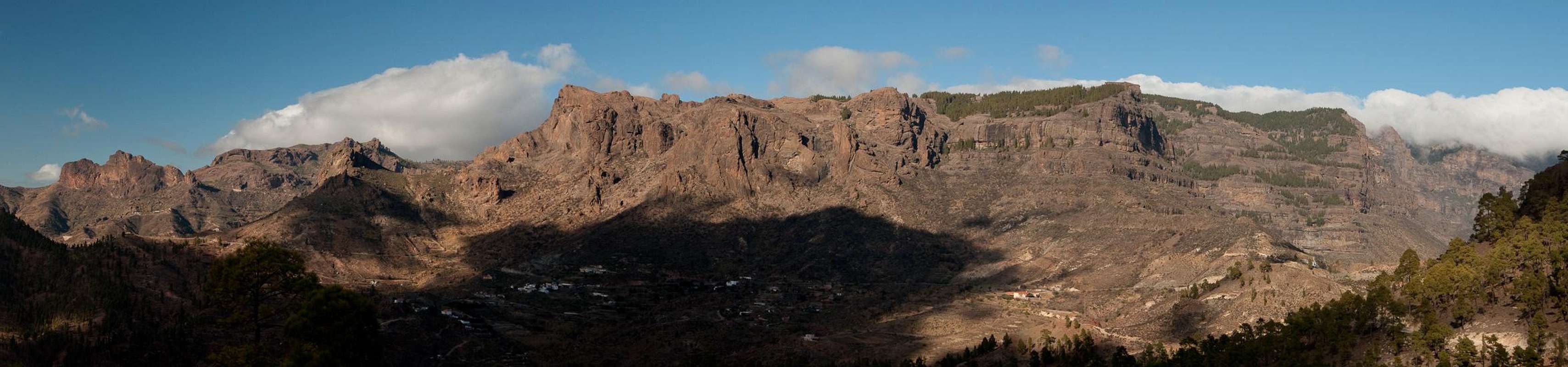
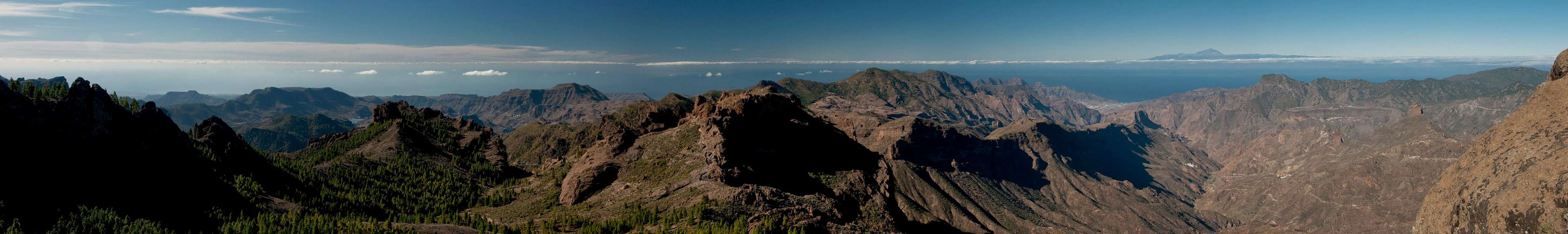
Gran Canaria's central mountain range, the Cumbre Central, is a basalt high plateau right in the middgle of the island. The plateau takes all space between the island's huge erosion craters, Caldera de Tejeda in the north-west and Caldera de Tirajana in the south. At almost all sides the plateau drops into the craters with impressive walls, nowhere more imposing than at it's western end. GC60 the Careteria Central, the road between San Bartolomé de Tirajana and Tejeda passes underneath these walls through the saddle Degollada del Asserador. Cars on the road are dwarfed by the hundreds of metres of vertical basalt above. The mountains, which make up the walls are Riscos del Laurel, Los Canadores and Montaña del Asserador.
 |  |  |
While Los Canadores are reserved for climbers, a broad vally between the other two mountains facilitates access to them. The route between La Goleta (and Roque Nublo) and Degollada del Asserador, considered one of the most beautiful and must-do routes of the island, runs right through that valley and offers access to the summits from their shallow eastern ends. Still main importance of the mountain is as a climbing destination.
 |  |  |
The north face, which drops into Caldera de Tejeda is about 5km long with one steep gully breaking it up in western and eastern sections. The red basalt is solid with amny features like cracks and ledges. The west face is shorter with some lower angle slabs placed in front of it. There are large roofs and caves in the topmost part of the face as well as a large dihydral in its center. The north and east faces are separated by a shap prow, itself one of the most interesting features.
 |  |  |  |
While climbing is possible on all faces, traffic is mostly concentrated on the east face above Degollada del Asserador, and here mainly restricted to the slabs. These are used as training climbs and you can find whole schools of people there. Ledges offer easy descent routes, making the climbs very popular. Climbing centre of Gran Canaria is nearby Ayacata, a small mountain viallge almost solely dedicated to climbing. You'll find good information in the two inns of the hamlet.
Getting There
  |
Gran Canaria can be reached from any major European airport. Usually charter carriers fly there but the spanish airline Iberia has also regular flights. The airport is on the eastern coast of the island, far away from the tourist centres in the south.
Trailheads for Montaña del Asserador are at Degollada del Asserador and La Goleta near Roque Nublo. This latter trailhead is a bit far off but you'll close in on the mountain from above, thus having a better overview which bushwhack to take to the top. On maps you can also find an old trail from the road between Cruz de Timagada and Degollada del Asserador but I haven't been able to find it.
- From the south
- From Maspalomas take GC60 through Fataga and San Bartolome to the saddle Cruz Grande.
- From the saddle stay on GC60 until you get to Ayacata.
- For Degollada del Asserador stay on GC60.
- For La Goleta turn onto GC600 east
- From the north
- From Telde take GC131 which turns into GC130, direction Pico de la Nieve. The road will hit GC150 right at Gran Canaria's highpoint.
- Stay on GC150 for a few metres, then turn onto GC600 to Ayacata.
- The road passes La Goleta after only a few km.
- For Degollada del Asserador turn right onto GC60 at Ayacata.
Red Tape
Montaña del Asserador is part of the Parque Rural del Nublo. The usual rules apply.Accommodation
 |
Gran Canaria has a lot of options for accommodation. Most visitors book hotel rooms from their travel offices or over the internet. However, you will most certainly end up in the ugly tourist centres along the south coast. Therefore a much better solution is to rent a holiday home, most often a rural finca. This can also be done by travel office or internet.
Camping is a bit of an issue on all the Canary Island. There are designated camping zones but getting a place often involves some bureaucracy. The closest campground is at Embalse de las Cuevas de las Niñas some 4km to the south-west of the mountain. Wild camping is not permitted anywhere on the island.
Weather Conditions
The following table gives a rough general overview over the weather on Gran Canaria, at sea level.| Month | Jan | Feb | Mar | Apr | May | Jun | Jul | Aug | Sep | Oct | Nov | Dec |
| Avg. day temp.[°C / °F] | 21 / 70 | 21 / 70 | 22 / 72 | 22 / 72 | 22 / 72 | 23 / 73 | 24 / 75 | 25 / 77 | 25 / 77 | 25 / 77 | 24 / 75 | 22 / 72 |
| Avg. night temp.[°C / °F] | 16 / 61 | 16 / 61 | 16 / 61 | 17 / 63 | 16 / 61 | 17 / 63 | 18 / 64 | 20 / 68 | 20 / 68 | 18 / 64 | 18 / 64 | 17 / 63 |
| Water temp.[°C / °F] | 19 / 66 | 18 / 64 | 19 / 66 | 19 / 66 | 19 / 66 | 20 / 68 | 22 / 72 | 23 / 73 | 23 / 73 | 23 / 73 | 21 / 70 | 20 / 68 |
| Rainy days | 4 | 3 | 2 | 2 | 1 | 1 | 1 | 1 | 1 | 3 | 3 | 3 |
The Canarian Islands (as well as Madeira) are located in the trade wind zone. You almost always encounter northeastern winds which carry a lot of humid air. Being forced to climb to higher altitudes this moisture condenses into clouds. This in return means that most of the time the northeastern part of the islands is covered in clouds from altitudes of 1000m through 1500m.
The mountainous region in the centre of the island is of the same alltitude and higher and thus stops the clouds. While the northern parts of the islands can be foggy and rainy the southern parts most often are sunny and hot. On Gran Canaria the north-eastern part of the island collects almost all moisture. However, unlike on the other Canary Islands no cloud forest remains. The laurisilva fell victim to the agricultural development of the island.
Maps & Books
Regular Maps
- Gran Canaria
Kompass Map WK237
Kompass Verlag
1:50000
ISBN 3-85491-114-9
- Gran Canaria North
Public Press Map 442
1:50000
ISBN: 978-3-89920-442-1
- Gran Canaria South
Public Press Map 443
1:50000
ISBN: 978-3-89920-443-8
Digital Maps
Kompass is the only company known to me which offers GPS digital Maps. In addition for those of you with Garmin GPS receivers there is a map source map set of all Canary islands out there.
- Gran Canaria
Kompass GPS4237
Kompass Verlag
ISBN 978-3-85491-219-4
- Islas Canarias
Map Source custom map
By Manfred Pepper
downloadable zip-file
Books
My recommendation is a guidebook by Rother Verlag, available in English and German. The book is an excellent hiking guide covering all the interesting areas of the island. Since it comes with small maps for each excursion it might even be used without a map to support them.
- Gran Canaria
Izabella Gawin
Rother Verlag
ISBN 978-3-7633-4816-9 (English)
ISBN 978-3-7633-4000-2 (German)