
-
 4293 Hits
-
 79.78% Score
-
 11 Votes
|
|
Mountain/Rock |
|---|---|
|
|
47.32503°N / 11.44529°E |
|
|
Hiking |
|
|
Spring, Summer, Fall |
|
|
7694 ft / 2345 m |
|
|
Overview
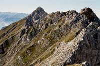
 Pfeiser Spitzen as seen from Kleiner Lafatscher
Halltal is a tributary valley to Inntal some km east of the town of Innsbruck. Famous for its salt mines in former times, which brought wealth and economic activities to the valley with the beginning of Medieval times, Halltal and the surrounding mountains in our days are a main touristic attraction and offer many trails, routes and summits for the mountaineer.
Among those summits, Pfeiser Spitze is one of the more unknown. Located in the southwestern part of the Halltal and belonging to the Inntal group of the Karwendel ranges, Pfeiser Spitze is, due to its bold and spire - like appearance, a summit for locals and insiders. The north face of the mountain is indeed impressive: a chain of needles, spires and peaks rising perpendicular out of the scree fields of upper Halltal. Even from Stempeljoch col, the northwestern limitation of this chain, Pfeiserspitze looks like a very difficult ascent. So most people summit Stempeljochspitzen, the northwestern neighbours of Pfeiser Spitze.
The south face on the Inntal side is likewise impressive because of the 1.700 m slope from the valley ground to the summit.
The two main ascents from Stempeljoch and from Törl, a col located east of Pfeiser Spitze, can be combined to a nice traverse, which includes the summits of Lattenspitze, the eastern neighbor of our summit, and Wildangerspitze. Between Lattenspitze and the summit is a short and easy, but in part airy via ferrata; the ascent from Stempeljoch, too, is secured with some steel ropes.
There is only one minus point: the summit itself is so tiny that hardly one person can sit down for a rest. The summit is just the highest spire of all those spires, peaks and needles which build the ridge between Pfeiser Spitze and Lattenspitze and in addition there is the inevitable summit cross, taking its space. But I´m sure: you will find another needles top to sit down and have a look on Karwendel to the north, east and west and to Tuxer Alpen, Inntal, Stubai and Zillertal range to the south.
Getting There
 Pfeiser Spitzen closeup
Main trailheads for Pfeiserspitze are
You reach Halltal
Halltal trailhead:
Halltal - Ißbrücke, the very last trailhead along the Halltal road.
Current regulations for Halltal (08 / 2014):
Halltal is closed to public traffic and will be so in the future. This is due to security regulations (landslide areas along the road).
Actually there is a shuttle bus service on weekends with good weather during the summer months (see schedule and prices here ).
This bus starts at Absam / Halltal parking area and ends at the Sankt Magdalena mountain inn. With this bus it is possible to reach all the Halltal trailheads without walking or at least with only a short additional walk.
During the week and in autumn a taxi service is available to the trailheads; prices actually (2014) range from 18 € to 23 € up to 5 persons and 25 € to 30 € up to 8 persons.
Thaur trailhead
Parking area at the end of Stollenstraße. Proceed uphill on that road until you reach the parking area on your left. You reach Thaur by using road number L 372 from Innsbruck or from Absam above Hall.
 Pfeiser Spitzen and Lattenspitze (right), Rumer Spitze (left) as seen from Ambras Castle, Innsbruck
Pfeishütte
Pfeishütte is an alpine club hut located in the uppermost Gleirsch valley / Samertal valley. You reach Pfeishütte:
Routes Overview
 Pfeiser Spitzen, Lattenspitze and Törl route
Halltal route
From Halltal trailhead follow the former toll road into the valley and the forest road in western direction to Herrenhäuser. Choose trail number 218 to Törl. Alternatively follow the forest road from Herrenhäuser to Issjöchl. Follow trail number 221 in the direction to Stempeljoch. After some 100 meters take the left hand trail at a trail junction and traverse the Wildangerspitze east slopes up to Törl.
At Törl follow the trail in western direction which zigzags up the east ridge of Wildangerspitze and Lattenspitze until you reach the summit. Descend shortly on the western side of Lattenspitze summit and traverse the south slopes between Lattenspitze and Pfeiser Spitze until you reach a huge chute, where a short via ferata starts, traversing the chute and leading you up to the short and airy ridge crest to Pfeiserspitze summit.
Thaur route
From the Thaur trailhead follow the marked route up to Thaurer Alm which in its lower parts bypasses the forest road switchbacks and follows the forest road in its upper parts.
At the last switchback in front of Thaurer Alm leave the forest road to the right and follow the trail number 218 up to Törl, first traversing the steep south slopes of Lattenspitze then following the red-white-red marks off trail, ascending the meadow valley between Wildangerspitze and Kaisersäule, a tributary summit of Thaurer Zunterkopf with a monument (don´t follow the trail to Kaisersäule!).
At Törl, proceed as described for Halltal route.
Route from Pfeishütte
From Pfeishütte follow trail number 221 up to Stempeljoch. Before reaching Stempeljoch choose the right hand trail, traversing the scree fields below Pfeiser Spitze and ascend the rock chute to the south ridge of Pfeiserspitze. Follow the marking on the ridge to Pfeiserspitze summit.
 Lattenspitze - Pfeiser Spitzen traverse Lattenspitze - Pfeiser Spitzen traverse |  The short Via Ferrata at Pfeiser Spitzen The short Via Ferrata at Pfeiser Spitzen | 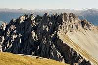 Pfeiser Spitzen as seen from Stempeljochspitze Pfeiser Spitzen as seen from Stempeljochspitze |
Wildangerspitze – Lattenspitze – Pfeiser Spitze traverse
The whole traverse is described here.
Red Tape & Accommodation
 Mighty Roßkopf; neighbour of Pfeiser Spitzen
Red Tape
Pfeiser Spitze is part of the “Alpenpark Karwendel”, an important and strictly protected national park.
There is no entrance fee for the park but many regulations to follow. Please respect the following rules in the National Park:

There is a National Park Information Center at Hinterriß.
Accommodation
Camping is not allowed within Alpenpark Karwendel.
Food and lodging can be found at
Mountain huts
Gear & Mountain Conditions
 Pfeiser Spitzen and Stempeljoch as seen from Lafatscher Joch
Pfeiser Spitze is a hiking summit for late spring, summer and autumn, due to snow conditions in the early and late season. You need full hiking gear and, as the upper parts of the summit are very steep, no fear of vertigo.
The traverse to Pfeiser Spitze and to Stempeljoch col is a bit more difficult, as there is a short Via Ferrata and some exposed and airy but easy rock scrambling involved. A helmet can be useful in these parts of the full traverse.
Current Weather:
Maps & Guide Book
 Happy days at Thaurer Alm.......
Maps
Alpenvereinskarte, 1 : 25.000, Karwendelgebirge, Mittleres Blatt, number 5/2, 2008
Alpenvereinskarte, 1 : 50.000, Innsbruck und Umgebung
Guide Book
Walter Klier: Karwendel alpin, Alpenvereinsführer, Bergverlag Rother, München, 16th edition, 2011
Add External Links text here.