
|
|
Mountain/Rock |
|---|---|
|
|
46.71998°N / 11.06025°E |
|
|
Hiking, Mountaineering, Scrambling |
|
|
Spring, Summer, Fall |
|
|
9836 ft / 2998 m |
|
|
Overview
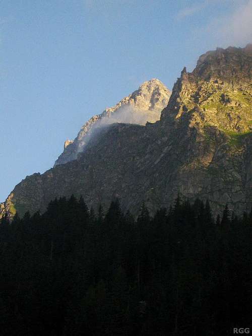
The top of Tschigat is illuminated by the early morning sun. Seen from the ESE, from Schutzhaus Hochgang (1839m).
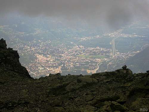
Zooming in on a sunny Meran, 2.5 km below, right before I entered the clouds and visibility dropped dramatically
Ridges
Two clearly defined ridges come together on the summit: one to the WNW and one from the NE.From the summit, the WNW ridge, usually simply called the west ridge, descends to the Halsljoch (2808m), a high alpine saddle with a hiking trail crossing it. On the other side of the saddle starts the SE ridge of the Lazinser Rötlspitze (3037m), Tschigat's parent peak, giving it a prominence of 190 m.
The NE ridge first descends to the Milchseescharte (2707m), another high alpine crossing, and then eventually to the Spronser Joch (2581m).
The Halsljoch and Milchseescharte are connected by a difficult hiking trail traversing the northern slopes. This can be useful as an alternative for a traverse when the weather is too poor or the routes are out of shape, and convenient if you want to traverse the mountain and then return to wherever you started.
There are several other, less clearly defined ridges, including a much steeper one to the south.
Faces
The mountain is steep on all sides - too steep for hikers that is. Overall, the north face is the least steep though, and I imagine that an expert skier could get down there in winter - slowly though, to find a safe route. The north as well as the somewhat steeper east face offer a way up for scramblers. The southwest and south side are much steeper still, and I don't know about any routes up there.The north face used to be the home of a tiny glacier, and even some relatively recent maps still show it, but it's been gone for some years now. Still, with snow on the mountain, you can imagine what it would have looked like.
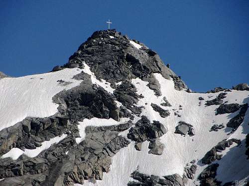
The summit is small, but not too small to have a massive summit cross. You can see it from far away.

Tschigat from the south, from the village of Rabland
The green paddle points at Tschigat.
Zoom in for a closer view, or click here to view a larger map
Zoom in for a closer view, or click here to view a larger map
What's in a name
Tschigat lies in Süd-Tirol, a relatively autonomous region in Italy these days. The main language is German. In earlier days, that was different: German was suppressed, and all geographical features received Italian names. In Italian, the mountain is called Cigot.A note on the elevation
While most sources give Tschigat an elevation of 2998 m, some maps and books say 3000 m. In fact, many peaks in the area show some variation in height across different maps, so it doesn't come as a surprise that there isn't only one value for Tschigat either. But this round value makes me suspicious. Maybe I'm wrong, and it was really measured as 3000 m some time ago, but I can't shake the thought that that someone decided that crossing the 3000 m mark made it a more important peak, and so, whatever the measurement was, it was rounded up a bit. Until the local geographical institute measures it accurately again, I'll stick with 2998.
A snow covered Tschigat, seen from the NW. The summit is just left of center, with a shiny cross on the top.
The saddle on the far right is the Halsljoch. The normal route follows the ridge from there.
Getting There
Getting to the area
The nearest city is Meran, a pleasant place southeast of the Texel Group. In summer, the area attracts a lot of visitors and for a small city it is well connected.
Pfelders
By car
- From the north there are three options:
- Along the provincial road over the Reschenpass via Nauders and then down the Vinschgau valley;
- Via the mountain road over the Timmelsjoch (closed in winter) and then down the Passeiertal;
- Over the Brenner motorway via Sterzing, and then also down the Passeiertal.
- Along the provincial road over the Reschenpass via Nauders and then down the Vinschgau valley;
- From the south, the only way is by the motorway from Bolzano.
- From Switzerland, in the west, the Ofenpass and then down the Vinschgau valley is the most logical route.
By public transport
Meran has regular train connections with Bozen / Bolzano, which is well connected to the rest of the Italian rail network as well as to Austria and Germany to the north. In addition, a regional train heads up the Vinschgau valley, west of Meran, as far as the small village of Mals.
From the north, from Austria, regular buses come over the Reschenpass to Mals. And likewise, from the west, from Switzerland, regular buses come over the Ofenpass to Mals.
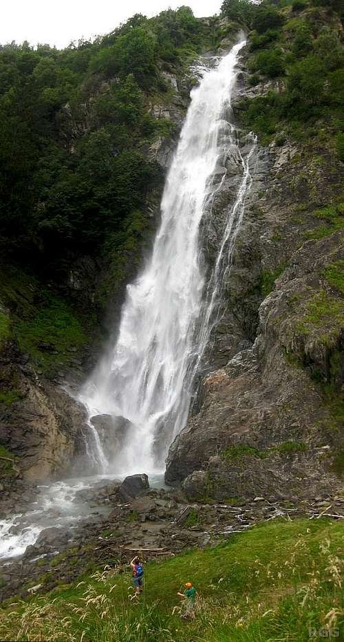
Partschinser Falls
Trailheads
From the north
The most convenient trailhead is the village of Pfelders (1628m). The Pfelderer valley is a side valley of the Passeier valley north of Meran. Pfelders can be reached by bus, and there is ample parking space.From the east or southeast, via the Spronser Lakes
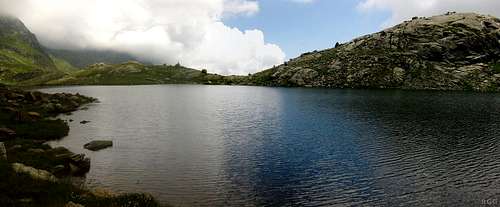
The Langsee, the largest of the Spronser Lakes
If you don't want to use the cable car, in the vicinity of Meran the highest place to park your car is at Gasthof Walde (1310m), just above the hamlet of Vernuer, north of Meran. However, from there the trail starts downhill and you'll loose about 250 m before going up again.
From the south, via the Lodnerhütte
For a multi-day trip, the Lodnerhütte is conveniently located in the center of the Texel Group, only a few kilometers west of the Halsljoch. Of the many ways to get there, the shortest one is from the south, hiking up the Zieltal. From the Birkenwald car park (980m), still fairly low in the Zieltal above the village of Partschins, it's about 4 hours to the refuge. Early on you'll pass by the impressive Partschinser Falls.Alternatively, to save an hour and some energy, you can start by taking the Texelbahn cable car from Partschins up to the Giggelberg (1544m) and hike north on the Meraner Höhenweg to the Nassereithhütte (1523m) and from there up the Zieltal to the Lodnerhütte.
Routes
West ridge, UIAA grade I
The normal route is a scramble up the WNW ridge, or simply called the west ridge, from the Halsljoch. The ridge is clearly defined and as if that's not enough, there are paint marks along the route, so even in poor visibility it's virtually impossible to get lost. Higher up, there are some steel cables - but their rusty appearence doesn't inspire a lot of confidence. Still, they also point out where to go.The route is UIAA grade I, which means it's an easy scramble. However, most hikers will find the exposure and the occasional climbing moves too much for comfort.
From the saddle the climb takes about an hour. Going down isn't all that much faster.
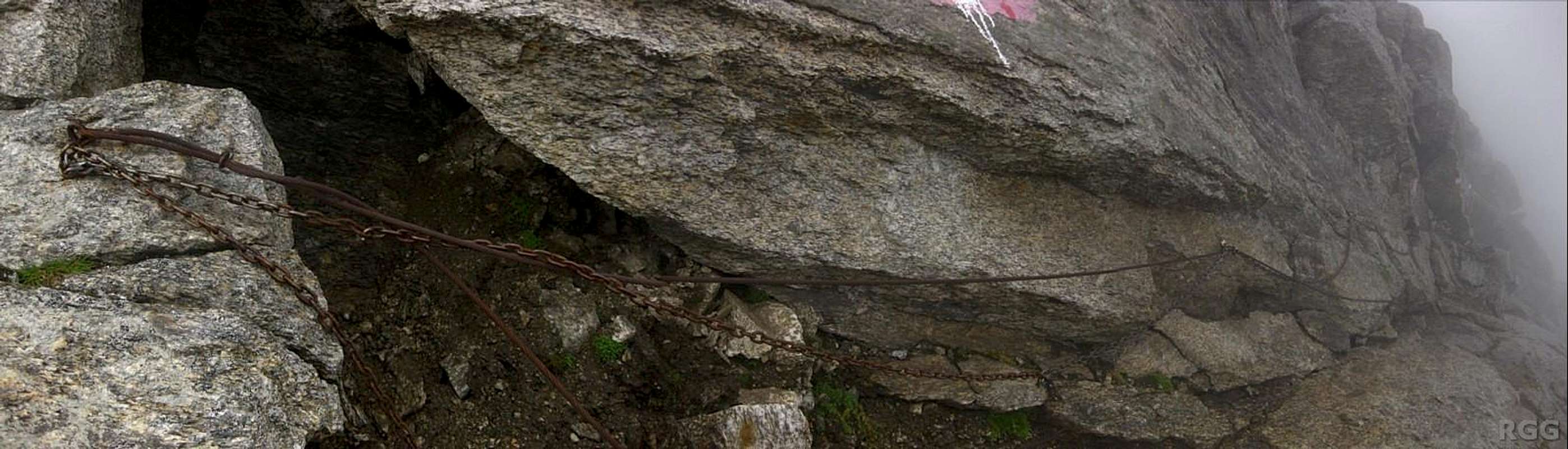
Rusty steel cables high on the W ridge
Entering the chimney
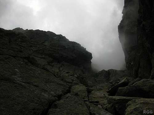
East face, UIAA grade II
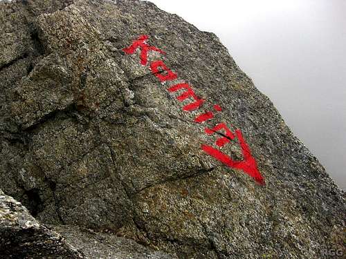
"Kamin" is German for chimney. To descend the east face, this is the sign to watch out for!
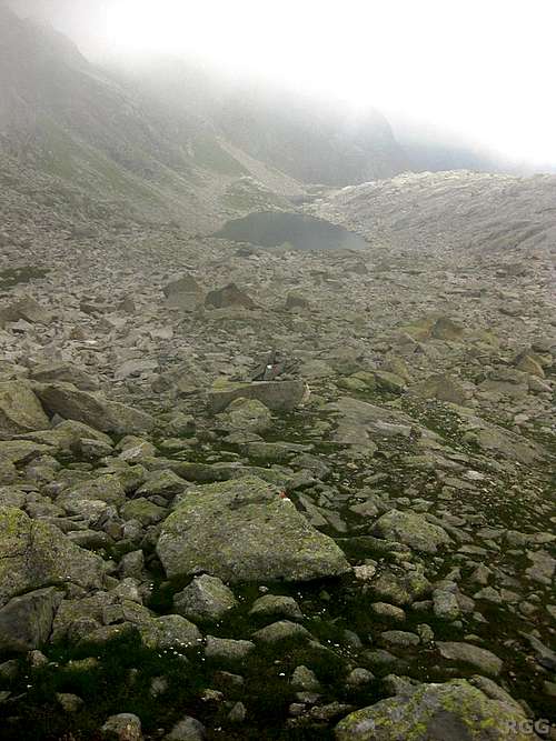
Looking down the talus below the Tschigat east face, with the Milchsee below. Frankly, on the way down it hardly matters whether you see the paint marks. The map will show you that the trail, or what passes for one, goes around the lake on the right side, but the terrain on the left side isn't any harder.
On the way up, the route is obvious. However, on the descent, pay attention for the big red sign pointing down the chimney, for if you miss it, you end up descending the more difficult NE ridge instead!
From the Milchsee the ascent takes about an hour and a half.
Other routes
- N face, UIAA grade II.
- NE ridge, UIAA grade III.
If you have personal information about these routes, let me know - or better yet, write a route page.
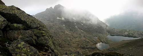
A foggy Plattenspitze and the Tablander Lacken, seen from the Tschigat W ridge
Getting to the Halsljoch
The main trails to the Halsljoch are nr 40 from the north, about 4 hours from Pfelders, and nr 7 from the west, the better part of 2 hours from the Lodnerhütte. Right below the Halsljoch this trail passes the Tablander Lacken.
A third trail traverses the northern slopes of Tschigat, connecting the Halsljoch with the Milchseescharte.
![Descending from the Milchseescharte (2707m) to the Milchsee (2540m)]()
Looking down the very steep trail from the Milchseescharte to the Milchsee. In the upper left, the Langsee is visible as well.
From the north comes trail nr 40a, also about 4 hours from Pfelders. From the east comes trail 7, very steep and secured by cables. However, although some maps show this as a trail, this can't be called a normal hiking trail anymore: the section directly below the gap is short, but nevertheless it's UIAA grade I!
![Signpost between Hochgangschartl and Milchsee]()
Signs between Hochgangschartl and MilchseeTo get to the Milchseescharte from the Leiter Alm or from Hochmuth to the east, first hike west along the Meraner Höhenweg to Schutzhaus Schutzhaus Hochgang (1839m). This takes 1-1.5 hrs from the Leiter Alm, an additional hour from Hochmuth. From there turn north, up to the Hochgangscharte. Soon the trail gets real steep and rugged. There are some cables high up along the trail.
Directly north of the Hochgangscharte is the Langsee, the biggest of the Spronser Lakes and the Milchsee isn't far away to the west, and the trail to the scharte is on the north side it it. Signs point the way.
![Lodnerhütte]()
LodnerhütteA more interesting but longer variation is to traverse the mountain. Again starting at Pfelders, hike up to the Milchseescharte and descend on the other side, then scramble up the east face, descend the west ridge to the Halsljoch and hike back down to Pfelders from there.
Another, even longer option to traverse the mountain, is to start at the Leiteralm, go over the Hochgangscharte to the Milchsee and scramble up the east face. And now, to avoid retracing your steps, descend the west ridge to the Halsljoch, continue west to the Lodnerhütte and then hike all the way down the Zieltal.
If you have more than just one day, there are a whole lot of other options, with many including a stay at the Lodnerhütte. That's what I did - after starting in Pfelders and doing the E-W traverse.
![Schutzhaus Hochgang]()
Looking own on Schutzhaus Hochgang from the trail to the Hochgangscharte![Poor weather approaching]()
Marginal weather descending upon the Guido Lammer shelterThe nearest refuge is the Lodnerhütte. Even closer, right below the Milchseescharte, on the north side, lies the Guido Lammer Bivouac: a basic shelter with room for about 10 people, with some old mattresses and blankets. It's always open and it's free, but if I would plan to spend the night there, I would bring my own sleeping bag and mat.
Other conveniently located refuges are Schutzhaus Hochgang and, a bit east of the Spronser Lakes, the Bockerhütte.
Along the Meraner Höhenweg there are many more places to stay, including the Leiteralm and Hochmuth.
And Meran and the many nearby villages offer countless accommodation options. In Pfelders I can recommend Pension Restaurant Rosmarie.
Wild camping is not allowed.
![Tschigat (2998m) summit pyramid]()
The summit pyramid
Pfelders
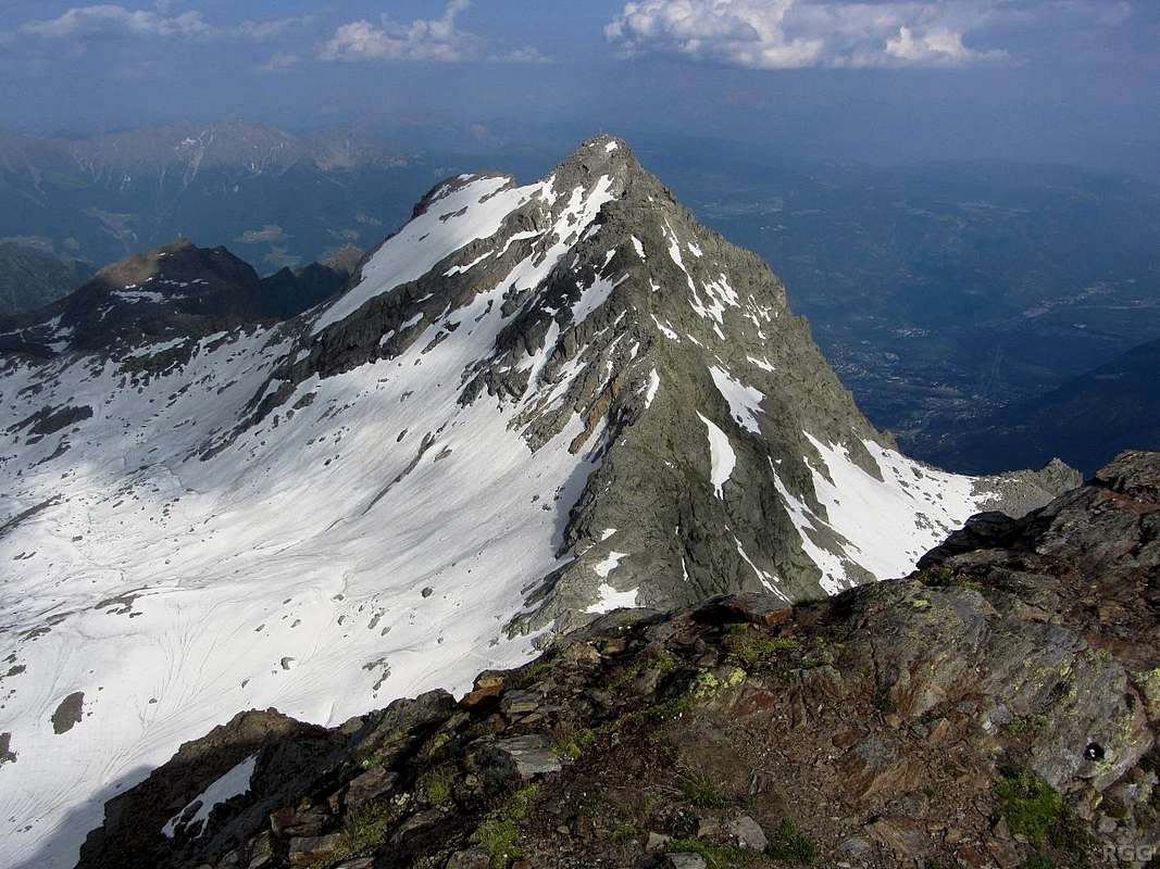
![Tschigat (2998m) from Lazinser Rötelspitze (3037m)]()
Tschigat from the Lazinser Rötelspitze, looking directly at the WNW ridge
A third trail traverses the northern slopes of Tschigat, connecting the Halsljoch with the Milchseescharte.
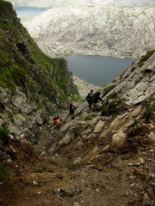
Looking down the very steep trail from the Milchseescharte to the Milchsee. In the upper left, the Langsee is visible as well.
Getting to the Milchseescharte
The Milchseescharte is a small gap on the NE ridge of Tschgat.From the north comes trail nr 40a, also about 4 hours from Pfelders. From the east comes trail 7, very steep and secured by cables. However, although some maps show this as a trail, this can't be called a normal hiking trail anymore: the section directly below the gap is short, but nevertheless it's UIAA grade I!
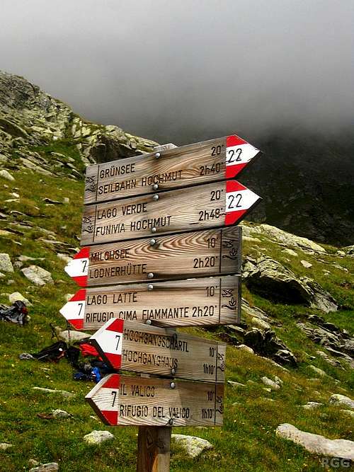
Signs between Hochgangschartl and Milchsee
Directly north of the Hochgangscharte is the Langsee, the biggest of the Spronser Lakes and the Milchsee isn't far away to the west, and the trail to the scharte is on the north side it it. Signs point the way.
Trip suggestions
Any one day trip will be a pretty long day. That said, the easiest way would be to start in Pfelders, hike up to the Halsljoch and scramble up the west ridge, and return the same way.
Lodnerhütte
Another, even longer option to traverse the mountain, is to start at the Leiteralm, go over the Hochgangscharte to the Milchsee and scramble up the east face. And now, to avoid retracing your steps, descend the west ridge to the Halsljoch, continue west to the Lodnerhütte and then hike all the way down the Zieltal.
If you have more than just one day, there are a whole lot of other options, with many including a stay at the Lodnerhütte. That's what I did - after starting in Pfelders and doing the E-W traverse.
When to Climb
The best period is from late spring to early fall.Accommodation
Looking own on Schutzhaus Hochgang from the trail to the Hochgangscharte
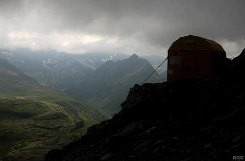
Marginal weather descending upon the Guido Lammer shelter
Other conveniently located refuges are Schutzhaus Hochgang and, a bit east of the Spronser Lakes, the Bockerhütte.
Along the Meraner Höhenweg there are many more places to stay, including the Leiteralm and Hochmuth.
And Meran and the many nearby villages offer countless accommodation options. In Pfelders I can recommend Pension Restaurant Rosmarie.
Wild camping is not allowed.
Red Tape
The Texel Group is a Natural Park, and is protected as such.Maps and books
The summit pyramid
- The 1:25000 Tobacco map Parco Naturale Gruppo di Tessa covers the whole national park. It is the most detailed map, but considering its scale, it gives relatively poor information.
- The 1:50000 Freytag&Berndt map WK S8, Passeiertal * Timmelsjoch * Jaufenpass is sufficient, although the 100m contours are rather coarse.
- Excellent free topographic maps are available at the base station of the Texelbahn cable car. It covers a somewhat smaller area than the other maps, and highlights the the Meraner Höhenweg, but it has all the other trails and many details. Just one minor point: The map legend claims it is scale 1:50000, but it is close to 1:60000.
- Alpenvereinsführer Ötztaler Alpen, Walter Klier. 14th ed. Bergverlag Rother, 2006, ISBN 978-3-7633-1123-1. In German.
External Links
VinschgauPfelders
Tschigat from the Lazinser Rötelspitze, looking directly at the WNW ridge