
-
 4008 Hits
-
 77.48% Score
-
 8 Votes
|
|
Mountain/Rock |
|---|---|
|
|
27.94949°N / 15.69266°W |
|
|
Hiking |
|
|
Spring, Summer, Fall, Winter |
|
|
5200 ft / 1585 m |
|
|
Overview
 Montaña de Sandara above Caldera de Tejeda Montaña de Sandara above Caldera de Tejeda |
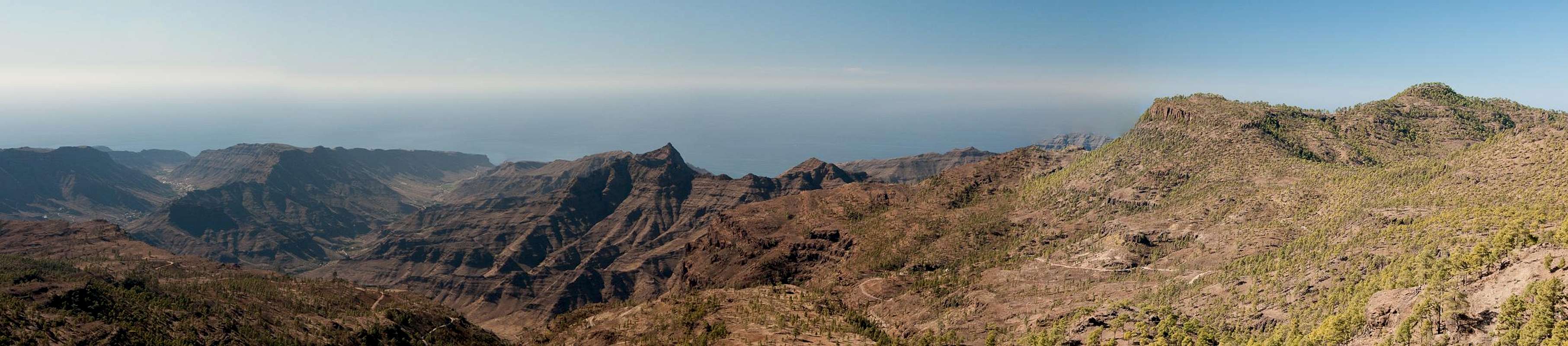
Caldera de Tejeda, the huge erosion crater in the east of Gran Canaria is bounded by two long curved ridges, which start from the Cumbre Central and lead to the west coast near San Nicholas de la Aldea. Both ridges offer wonderfully panoramic hikes, the northern one culminating in Los Moriscos near Artenara, while the southern one, the Pajonales Ridge, has its highpoint in Montaña de Sandara. The ridge starts at Degollada del Asserador, winding towards Montaña del Viso, high above Barranco de San Nicholas, the canyon which drains the caldera.
Montaña de Sandara is located centrally on the long ridge, which in general is loosely covered by Canary Pines. It is part of the Reserva Natural de Pajonales, a natural park, set aside to protect the very dry and brittle area. Infrequently, but rather regularly forest fires rage in the west and south-west of the island, burning the undergrowth but leaving the pines with their thick bark intact. The last of these fires raged in the summer of 2007 and the Pajonales Park is still struggling hard to recover. There is not much undergroowth yet and the pines only sprout thick clusters of their soft and long needles directly from their blackened trunks.
 |  |  |
The mountains on the Pajonales Ridge can be divided in two types: the morros - rocky basalt structures around which the soil has been eroded away over the centuries (e.g. Morro Pajonales and Morro de la Negra)- and round-topped tree-covered mountains like Montaña de los Jarones or Montaña de Sandara. The latter stands out as an exception not only because it is the highest summit on the ridge but also since its slopes have not been harmed by the big 2007 fire.
 | 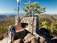 |  |
In consequence Montaña de Sandara is an island of green in the otherwise reddish brown Pajonales Area. The trees grow up to and upon the summit and only the southern view is relatively open. On the summit a fire lookout has been built to guard the south of the island. However, nowadays it is only sporadically used. The panoramic pictures on this page have been taken from relatively open spots on the slopes of the mountain, which is nearly circled by the pajonales ridge route. This route passes the mountain but from a saddle to its west a short but very steep unmarked path leads to the top.
Panoramic View
  |
Getting There
Gran Canaria can be reached from any major European airport. Usually charter carriers fly there but the spanish airline Iberia has also regular flights. The airport is on the eastern coast of the island, far away from the tourist centres in the south.Trailheads for Montaña de Sandara are at Degollada del Asserador, El Juncal and at Presa de las Cuevas de las Niñas.
- From the south
- From Maspalomas take GC60 through Fataga and San Bartolome to the saddle Cruz Grande.
- From the saddle stay on GC60 until you get to Ayacata.
- For Embalse de las Cuevas de las Niñas turn left onto GC605 which passes the reservoir.
- For Degollada del Asserador and El Juncal stay on GC60. The road to El Juncal turns off left about 500m after the degollada.
- From the north
- From Telde take GC131 which turns into GC130, direction Pico de la Nieve. The road will hit GC150 right at Gran Canaria's highpoint.
- Stay on GC150 for a few metres, then turn onto GC600 to Ayacata.
- For Embalse de las Cuevas de las Niñas turn left onto GC605 which passes the reservoir.
- For Degollada del Asserador and El Juncal stay on GC60. The road to El Juncal turns off left about 500m after the degollada.
Routes Overview
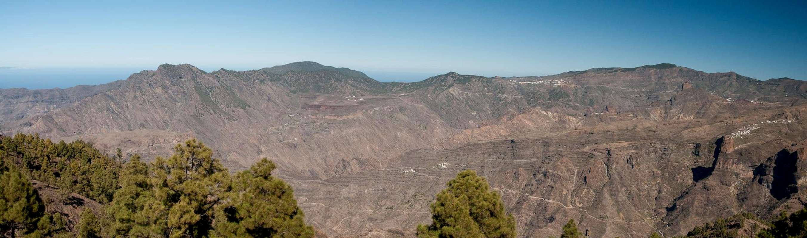
 Looking across the Pajonales ridge with Montaña de Sandara to the right
- Pajonales Ridge Traverse from Degollada del Asserador: a wonderful hike along the Pajonales Ridge with exceptional views to the Cumbre Central. Montaña de Sandara lies beyond the saddle Cruz de la Huesita so a round trip is a very long affair. Still this is the most panoramic of routes.
![Trailhead in El Juncal beneath Montaña del Asserador and Los Canadores]()
![Morro de la Negra (1465m) and Montaña Sandara (1583m)]()
![Los Moriscos (1772m), Roque Bentaiga (1415m) and Roque Palmes (1107m)]()
- Hike from El Juncal: A forest road leads from El Juncal to Embalse de las Cuevas de las Niñas. Park either in the village or some 2km along the road at a forest cabin. Hike the road to the saddle Cruz de la Huesita, where you turn west onto the Pajonales Ridge. The route is a combination of hikes along a dirt road and along paths. Only the last 500m are mostly pathless.
- Road Hike or Dirt Scrabmle to Cruz de la Huesita: From Embalse de las Cuevas de las Niñas either follow the dirt road to Cruz de la Huesita or - starting at the camping zone - hike along a steep path through the pine forest. Both routes lead to the saddle from where you turn west onto the Pajonales Ridge


Red Tape
 Upper Caldera de Tejeda with the Pajonales Crest to the right
The Pajonales ridge is part of Reserva Natural de Pajonales. Hiking and climbing are allowed, camping isn't. Take care with fire! In 2007 a huge forest fire raged the park and the whole south-west of the island, killing everything but the hardy Canary Pines.
Accommodation
Gran Canaria has a lot of options for accommodation. Most visitors book hotel rooms from their travel offices or over the internet. However, you will most certainly end up in the ugly tourist centres along the south coast. Therefore a much better solution is to rent a holiday home, most often a rural finca. This can also be done by travel office or internet.Camping is a bit of an issue on all the Canary Island. There are designated camping zones but getting a place often involves some bureaucracy. The closest campground is at Embalse de las Cuevas de las Niñas some 2km to the south of the mountain. Wild camping is not permitted anywhere on the island.
Weather Conditions
 |
The following table gives a rough general overview over the weather on Gran Canaria, at sea level.
| Month | Jan | Feb | Mar | Apr | May | Jun | Jul | Aug | Sep | Oct | Nov | Dec |
| Avg. day temp.[°C / °F] | 21 / 70 | 21 / 70 | 22 / 72 | 22 / 72 | 22 / 72 | 23 / 73 | 24 / 75 | 25 / 77 | 25 / 77 | 25 / 77 | 24 / 75 | 22 / 72 |
| Avg. night temp.[°C / °F] | 16 / 61 | 16 / 61 | 16 / 61 | 17 / 63 | 16 / 61 | 17 / 63 | 18 / 64 | 20 / 68 | 20 / 68 | 18 / 64 | 18 / 64 | 17 / 63 |
| Water temp.[°C / °F] | 19 / 66 | 18 / 64 | 19 / 66 | 19 / 66 | 19 / 66 | 20 / 68 | 22 / 72 | 23 / 73 | 23 / 73 | 23 / 73 | 21 / 70 | 20 / 68 |
| Rainy days | 4 | 3 | 2 | 2 | 1 | 1 | 1 | 1 | 1 | 3 | 3 | 3 |
The Canarian Islands (as well as Madeira) are located in the trade wind zone. You almost always encounter northeastern winds which carry a lot of humid air. Being forced to climb to higher altitudes this moisture condenses into clouds. This in return means that most of the time the northeastern part of the islands is covered in clouds from altitudes of 1000m through 1500m.
The mountainous region in the centre of the island is of the same alltitude and higher and thus stops the clouds. While the northern parts of the islands can be foggy and rainy the southern parts most often are sunny and hot. On Gran Canaria the north-eastern part of the island collects almost all moisture. However, unlike on the other Canary Islands no cloud forest remains. The laurisilva fell victim to the agricultural development of the island.
Maps & Books
Regular Maps
- Gran Canaria
Kompass Map WK237
Kompass Verlag
1:50000
ISBN 3-85491-114-9
- Gran Canaria North
Public Press Map 442
1:50000
ISBN: 978-3-89920-442-1
- Gran Canaria South
Public Press Map 443
1:50000
ISBN: 978-3-89920-443-8
Digital Maps
Kompass is the only company known to me which offers GPS digital Maps. In addition for those of you with Garmin GPS receivers there is a map source map set of all Canary islands out there.
- Gran Canaria
Kompass GPS4237
Kompass Verlag
ISBN 978-3-85491-219-4
- Islas Canarias
Map Source custom map
By Manfred Pepper
downloadable zip-file
Books
My recommendation is a guidebook by Rother Verlag, available in English and German. The book is an excellent hiking guide covering all the interesting areas of the island. Since it comes with small maps for each excursion it might even be used without a map to support them.
- Gran Canaria
Izabella Gawin
Rother Verlag
ISBN 978-3-7633-4816-9 (English)
ISBN 978-3-7633-4000-2 (German)