
-
 2143 Hits
-
 76.66% Score
-
 7 Votes
|
|
Route |
|---|---|
|
|
42.39079°N / 13.68867°E |
|
|
Download GPX » View Route on Map |
|
|
Most of a day |
|
|
Hike and Scramble |
|
|
Overview
 Ridge Scrambling on Monte Bolza Ridge Scrambling on Monte Bolza |
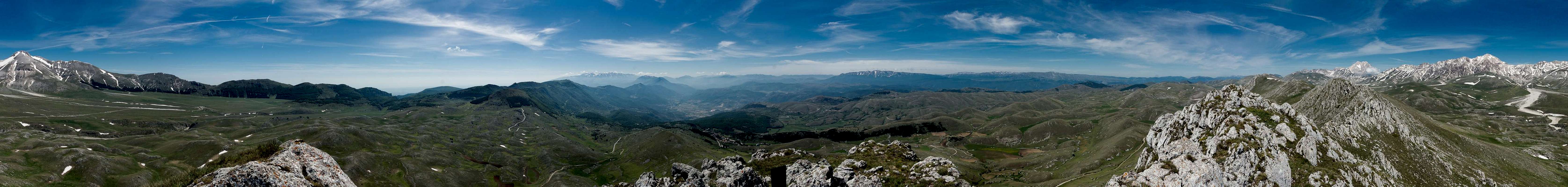
The traverse of the whole ridge of Monte Bolza is a wonderful day tour with exceptional views across Campo Imperatore towards the main summits of Gran Sasso 'Italia. It is listed as a hiking route but requires more than just walking practice. The ascent to the eastern summit is real steep and the meandering path across the rocky eastern part of the summit ridge is moderately exposed. There is no protection and you are on your own.
Access to the saddles to each side of Monte Bolza is easy. To the west there is a dirt road, to the east a well marked hiking path. There are no marks for the route to the eastern summit so you have to use your own judgement. We found the scramble to the southern foresummit (separated by a saddle from the eastern summit) practicable. We crossed the saddle and found minimal signs (withered arrows on the rocks) to guide us to the top.
The traverse follows the ridge except for a tower right in the middle of the rocky section, which you can pass on its northern side. Return to the ridge which gets less and less rocky and turns into a sequence of grassy hills. The western summit, Cima di Monte Bolza, is rocky again but requires no special skills. Descend along a path directly across the west slopes of the Cima.
Getting There
 Looking eastward across the Monte Bolza Summit Ridge
Monte Bolza is located to the south of Gran Sasso d'Italia right across the plain of Campo Imperatore, It can be reached from Rome or Pescara (the closest airports) via motorways A24 and A25. The last stretch to the trailhead at Castel del Monte runs across narrow mountain roads.
- From Rome:
- Southern access:
- Take motorway E80 / A24 from Rome to Torano.
- Switch to motorway A25, direction Pescara.
- At the exit Popoli / Bussi switch to SS163 north.
- Pass Bussi and Capestrano.
- Right after Capestrano turn onto SS602 through Ofena.
- After the village turn onto SS17bis, which will take you to Castel del Monte.
- Take motorway E80 / A24 from Rome to Torano.
- Northern access:
- Again, take motorway E80 / A24 from Rome to Torano.
- Stay on A24 until you reach the exit Assergi.
- Switch to SS17bis east, which will take you across Campo Imperatore and straight to Castel del Monte.
- Again, take motorway E80 / A24 from Rome to Torano.
- Southern access:
- From Pescara
- Take motorway E80 / A25 westward in direction Rome.
- At the exit Popoli / Bussi switch to SS163 north.
- Pass Bussi and Capestrano.
- Right after Capestrano turn onto SS602 through Ofena.
- After the village turn onto SS17bis, which will take you to Castel del Monte.
- Take motorway E80 / A25 westward in direction Rome.
Route Description
 Monte Bolza East Summit
- General:
- Start altitude: 1370m
- Summit altitude: 1927m
- Prevailing exposure: South, north
- Type: Hike and scramble
- Protection: None
- Start altitude: 1370m
- Effort: 2 - Elevation gain: 900m
- Power: 3 - Very strenuous ascent to the east summit
- Psyche: 2 - Moderately exposed on the eastern part of the ridge traverse
- Difficulty: 2 - Easy
- Orientation: 3 - Easy but for the east summit ascent and the eastern part of the ridge
 |  |  |
Starting point is the intersection of SS17 bis above Castel del Monte, where it crosses Viale dei Pini (there is a barrier on the main road, open in summer. To the right of the Viale there is a smal parking space.) Cross SS17 bis and head up the narrow road for a few metres. A marked path (Sentiero Italia) turns off to the right and heads up the western slopes of Monte Licciardi passing its summit to the west. The path heads up to the saddle between Monte Licciardi and Monte Bolza right beneath the latter's eastern summit. It heads over to the broad Guado della Montagna offering the first views of Campo Imperatore and the high mountains of Gran Sasso.
 |  |  |
Now orientation gets tricky. While the Monte Bolza East Summit is impossible to overlook the route towards the top is hard to find. We only managed by following a GPS track and even this was far from obvious. Generally, from Guado della Montagna the east summit appears to be twin peaked. Pass over to the soth-eastern fore summit and scramble up its slopes until you reach the col which separates it from the higher east summit. You have to freestyle among rocks and boulders, heading up very steep grass slopes. Once in the col you will find withered markers indicating the route to the top, which remains equally steep until you reach the very top.
  |
There you'll encounter one of the best panoramas you can have in all of Gran Sasso with the main summits of the range taking center stage. up front, to the west, you will see the summit ridge of Monte Bolza with its highpoint, Cima di Monte Bolza, at its far end. In addition there are Monte Velino, Monte Sirente and the high mountains of the Majella Range to the south.
 |  |  |
The next section requires some scrambling among the rocky summits of the Monte Bolza summit ridge. There is no path but the direction is obvious, being wedged between the sharp drops to both the north and the south. The route isn't particularly difficult as the ridge only occasionally narrows down to knife-edge character but there are several tricky sections where it crosses some of the saddles between the roughly half a dozen minor summits.
 |  |  |
After having passed the first two of these summit four is a tower with sheer drops to three sides. Circumvent it by descending to the north side and pass the tower at its base. Once on the far side a steep scramble is required to regain the summit ridge. Two more minor summits follow before the ridge gets broader and less rocky. There is a broad standalone summit more or less in the middle of the traverse after which a long descent starts.
Finally, you reach another saddle right at the base of Cima di Monte Bolza. The Cima is also twin peaked with the higher of the two summits to the west. You can climb both, again enjoying the fabled views up there.
 |  |  |
Descend Cima di Monte Bolza towards Sella di San Cristoforo heading down the west slopes without so much of a path. The top section is rather steep but a you get near the saddle the slope levels out. From the saddle a dirt road takes you back to Castel del Monte following the south slopes of Monte Bolza, where you have some nice views of the ridge you hiked before. The road ends directly at the trailhead at Viale dei Pini.