
-
 8433 Hits
-
 84.82% Score
-
 19 Votes
|
|
Mountain/Rock |
|---|---|
|
|
37.79068°N / 107.5528°W |
|
|
Hiking |
|
|
Spring, Summer, Fall |
|
|
13165 ft / 4013 m |
|
|
Overview
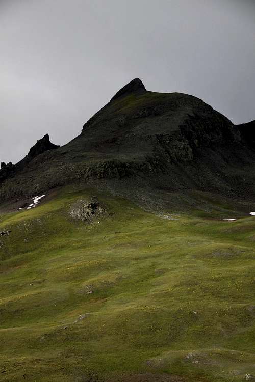
Stony Pass Peak
"Stony Pass Peak" = UN 13,165 feet is a quick jaunt from the Stony pass across the tundra and up a rocky ridge finish with just a little bit of scrambling. 40 minutes or even less to the top depending on your level of fitness and acclimatization. It is a perfect roadside attraction, quick summit with great views in all directions. And if you have extra energy left you can summit Canby Mountain just on the opposite side of the pass. Stony Pass is a popular 4 WD destination and the area has amazing wildflowers in the summer. The Stony Pass road is closed from mid fall into the start of the summer making winter access very long. The Continental Divide trail and Colorado Trail passes here and just below the eastern flanks of the Stony Peak.
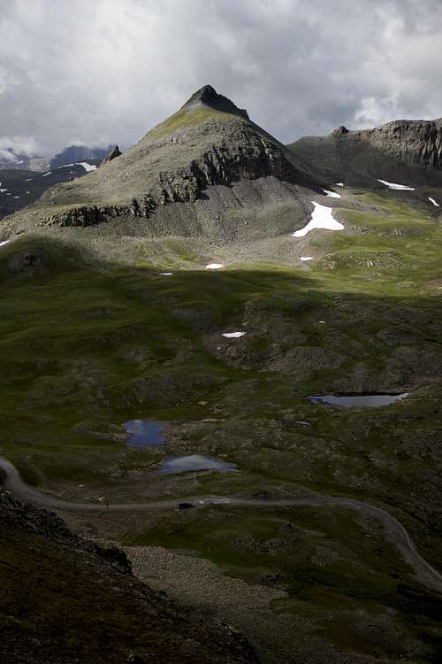
Stony Pass Peak
Total Mileage: 1 (1/2 mile up and 1/2 mile down)
Total elevation gain: 600 feet
Trailhead: Stony Pass
Trailhead Elevation: 12,590 feet
Nearby Mountains: the area is surrounded by many beautiful mountains. The views from the summit into the Grenadier range are spectacular.
Canby Mountain: 0.7 miles
Sheep Mountain: 1.99 miles
“Hardrocker”: 1.03 miles
“Could Be”: 0.75 miles
Green Mountain A: 0.56 miles
Little Giant Peak: 2.54 miles
Greenhalgh Mountain: 2.7 miles
Stony Pass got its name because of the rocky terrain. It was also called Hamilton Pass, after the builder of the first wagon road over the pass, and as Rio Grande Pass (the river flows on its eastern side). The Stony Pass crossing holds a great deal of historic interest. The Ute used the trail for centuries, and Spanish artifacts have been found in the area. It is believed that prospectors started to use the pass since 1860s. Major Hamilton built a wagon road along the route in 1872. Initially the road was heavily used as a stage route and a major supply line for the 4,000 mining claims in the area.When the railroad reached Silverton in 1882, the pass was less frequently used. However, the route remained open and was classified as a state highway at one point in the early 1900s. Eventually, it was completely abandoned until the Forest Service reopened it in the 1950s as a 4WD recreational route.
![Wildflowers - Stony Pass]()
Wildflowers - Stony Pass![Stony Pass Peak]()
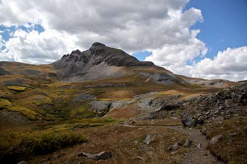
Stony Pass Peak
Stony Pass is accessible from Silverton (shorter and much easier) and from Creede/Rio Grande reservoir (a really long road in a very bad shape as of 9/2015). I drove the road in both directions and was amazed in what condition we found it heading towards Creede (tough sections start way pass the turn off for Beartown). Lots of water damage, huge potholes (more than 40 cm deep) - I would not take my car again all the way to Creede this way. The road from Silverton however is nice, only narrow at places making passing vehicles in the opposite direction difficult.
Getting There
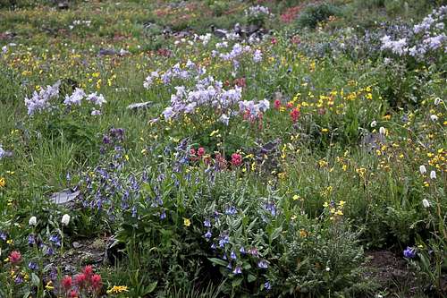
Wildflowers - Stony Pass
Stony Pass Peak
High clearance 4WD vehicle is necessary.
From Silverton drive north east past the courthouse and veer right onto County Road 2. On some maps this road is marked as #110. Pavement ends after a couple of miles. Around 4.2 miles you reach Howardsville (mostly some mining buildings). Turn here onto FS Road 589 - it is signed for Stony Pass/Cunningham Gulch. Shortly you come to an intersection - one to the left is signed for Old Mine Tour, the other one close to the creek continues straight. It does not matter which one you choose, both reconnect after 1-2 miles, and neither is technically challenging. There is more traffic on the Old Mine Tour fork of the road. Soon, you have to leave Cunningham Gulch and start your climb up the Stony Pass - FS 737. It is again marked and hard to miss. The road will begin to degrade some and high clearance 4WD is needed here. The road is steep at some sections and exposed and at other sections making passing other vehicles difficult. Mid July to August there are amazing wildflowers.
Stony Pass is a popular destination with ATVs and other off road vehicles. You are standing at 12,590 feet without any physical work!
Route
Northeast Ridge - is the standard route up "Stony Peak". The route is obvious from the road and getting lost is impossible. Walk your way across the tundra. Reach some rocky sections and find the easiest way up. There appeared to be a faint trail on the rocky sections. I found some internet reference rating the route as class 2+, I would say more class 2. There are a few loose rocks, but not much scree making the hike very pleasant, and as I mentioned above the summit views are spectacular. The tour up and down can be easily accomplished under 1 hr for a fit person, but one can also dwell up there and admire the surroundings - a perfect meditation spot. There was no summit register up there.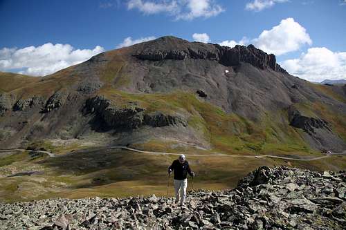 Stony Pass Peak - NE ridge, Canby Mountain in the background | 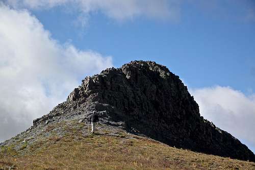 Stony Pass Peak - short and sweet final ridge |
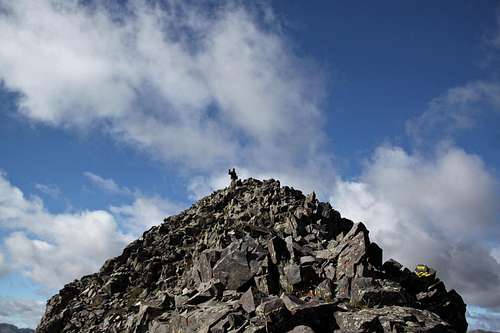 Stony Pass Peak - summit | 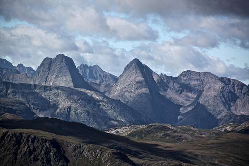 Summit view from Stony Pass Peak - Vestal and Arrow Peak |