
-
 2830 Hits
-
 78.27% Score
-
 9 Votes
|
|
Mountain/Rock |
|---|---|
|
|
46.48841°N / 9.68333°E |
|
|
Download GPX » View Route on Map |
|
|
Hiking, Skiing |
|
|
Summer, Fall, Winter |
|
|
9383 ft / 2860 m |
|
|
Overview
 Crappa da Tocf seen from the east Crappa da Tocf seen from the east |
Here is a mountain, purely climbed by accident. On a day forcasted to become stormy around noon we headed down from our destination, Fuorcla d'Agnel in the Albula Alps. Weather seemed to hold and since it was still early in the day we decided to attempt something else. I spied a whaleback of a mountain, unnamed on the map I carried, which nevertheless seemed to reach close to 3000m. We decided to attempt it - successfully. Later, at the apartment I found the name: Crappa da Tocf, 2860m.
The mountain is located to the north of Piz Neir, which at 2910m is only slightly higher. By some accounts Crappa da Tocf is considered the north summit of Piz Neir, even though a deep cut separates the two mountains. An east-west running broad ridge leads from Fuorcla degl Leget towards the summit, curved and bent like the back of a giant whale.
 |  |  |
One of the main attraction on the route is Himmelfenster, a rock window above Val Agnel, which can be seen from the valley but is difficult to find when up close. Made up from dolomite rock it looks foreign in the otherwise dark landscape (the "Neir" in Piz Neir stands for "black"). But on the far side of Val Agnel there is a large counterpart with Corn Alv, a mountain which could easily have its home in the Marmarole Group of the Dolomites.
 Piz d'Angel, Piz Surgonda, Corn Alv, Piz Julier Piz d'Angel, Piz Surgonda, Corn Alv, Piz Julier | ||
 Corn Alv Corn Alv |  Piz Bardella Piz Bardella |  Piz Julier Piz Julier |
 Piz Forbesch Piz Forbesch |  Piz Platta Piz Platta |  Piz Arblatsch Piz Arblatsch |
 Piz Fora Piz Fora |  Monte Disgrazia Monte Disgrazia |  Piz Roseg Piz Roseg |
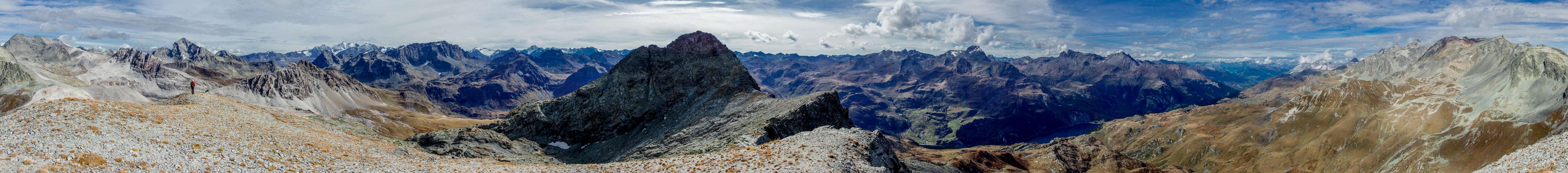
Crappa da Tocf is a wonderful lookout. Apart from close-up Piz Neir, which blocks part of the vista to the south, there are no further obstacles. Mainly the Albula and Platta Groups are on display but there are also a few windows towards the Bernina Group and Val Masino Alps. Most prominent, however, is the huge monolith of Piz Julier / Piz Güglia to he south-east.
360° Summit Panorama
  |
Getting There
 Piz Bernina, Piz Scerscen
Trailhead for Crappa da Tocf is Julierpass / Pass dal Güglia (2284m). It can be reached from Chur (motorway A13 via highway B3, which connects Chur with Silvaplana in Oberendadin across the pass.
Silvaplana can be reached from the north via B27 from Zernez, from the south-east via B29 across Berninapass or SS37 from Chiavenna in Italy. Here turn onto B3 to Julierpass.
Route
 Himmelsfenster
The route to Crappa da Tocf is straightforward. From Julierpass head northward into Val Agnel. To your left hand you'll have the east face of Piz Bardella. Once its north ridge runs out you'll reach an intersection, where you turn left (west), heading towards a rock window (Himmelsfenster). Pass it on its southern side and head for Fuorcla digl Leget.
In the saddle, leave the trail and head up the whale back of Crappa da Tocf. There are several steeper sections but even though the route is pathlesss it is easy enough.
Red Tape
Within the boundaries of the Albula Alps Switzerlands largest natural park, Parc Ela has been established. It protects the cultural, economic and natural heritage o an area where people have lived since the bronze age. Named after Piz Ela in its midst the park covers an area of 550 square kilometres, 200 of which are untouched nature. The 19 communities on its groundsupport the goals of the park and use them to attract visitors.Official Website
Weather Conditions
Accommodation
Maps & Books
Maps
Digital Maps
Regular Maps
- Julierpass
Swisstopo Map LK 268 T
1:50000
ISBN: 978-3302302683
- St. Moritz
Swisstopo Mao LK 1257
1:25000
ISBN: 978-3302012575
- Oberendagin / Alta Engadina
Kompass Verlag
1:40000
ISBN: 978-3850269094
Books
- Bündner Alpen 6
Manfred Hunziker
Sac Schweizer Alpenclub
ISBN: 978-3859021877
- Oberengadin - St. Moritz, Zuoz, Pontresina
Rudolf Weiss, Siegrun Weiss
Rother Verlag
ISBN: 978-3763340422
- Unterengadin. Scuol - Zernez - Münstertal
Rudolf Weiss, Siegrun Weiss
Rother Verlag
ISBN: 978-3763340439
- Skitouren Graubünden Süd: Oberhalbstein / Albula / Davos / Engadin
Vital Eggenberger
Sac Schweizer Alpenclub
ISBN: 978-3859023017