
|
|
Route |
|---|---|
|
|
40.69800°N / 110.979°W |
|
|
Backpack/Scramble |
|
|
One to two days |
|
|
Class 3 |
|
|
Approach
From Oakley (State Route 32), turn east on the Weber Canyon Road. Follow this road east for about 12 miles to where the Smith and Morehouse Road turns south. Go straight and pass under the big ranch gate that says "Thousand Oaks Ranch". This is a public road, the ranch just wants to make it look private. Read the sign that informs you that either side of the road is private land for the next several miles. The land between Thousand Oaks and Holiday Park is private, so stay on the main road and don't camp along it. Follow the good gravel road to Holiday Park. Once at Holiday Park, follow Uinta Road to the parking lot and outhouse at the trailhead. Do not cross the river on the 4wd road, look for a sign pointing out the trail to Abes Lake and Crystal Lake.
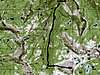
Route Description
From the trailhead, the trail climbs south and then slowly descends southeast to the Middle Fork Weber River. The trail then continues south and crosses the river a few times until reaching a junction after three miles from the trailhead. Go straight instead of left. The trail continues along the river for another mile to an area of cascades. The trail fades away at the cascades, but cross the river and look for it on the other side. From the other side of the creek, the trail continues upstream to the south and fades in a marshy area. The trail can be picked up again, though briefly, on the other side of the marshy area, though it fades yet again after a short distance. Just continue south through a small boulderfield. There are aslo some fallen trees to get over before the trail is picked up again. The trail crosses the creek again at a cairn and climbs to a bench about 100 feet above the creek. After following the bench for a ways, the trail becomes well marked with cairns. The trail is (or was?) also marked with painted spots on trees and rocks, but there was talk of the forest service removing these. About 7.5 miles from the trailhead, the trail reaches the pass between Mount Watson and "East Long Mountain". The best way to Mount Watson from the Middle Fork Basin is to head north and east from about .3 miles before (north of) the pass to the prominent West Ridge of Mt. Watson. Just contour around the hill until the West Ridge is reached. The route then follows the West Ridge to the summit. The first 500 feet of this climb up the ridge is very steep and has much boulder-hopping and scrambling, but after the first 500 feet, the ridge becomes easier. The round trip distance is about 16 miles, and since the trail is not well defined, and because of the scrambling, this is recommended as a two-day trip.

 |
Essential Gear
A good pair of boots is needed
Miscellaneous Info
If you have information about this route that doesn't pertain to any of the other sections, please add it here.