
|
|
Route |
|---|---|
|
|
40.16190°N / 106.1284°W |
|
|
Hiking, Skiing |
|
|
Summer, Fall |
|
|
Half a day |
|
|
Class 2 |
|
|
Overview
There are probably several routes that can be taken up Elk Mountain, but the West Slopes and South Ridge Loop is probably the best route. This route is 5.5 to 6.0 miles round trip depending on the exact route taken. This is the summit of Elk Mountain on June 26 2009. There were no views on that day!
Getting There
Via ParshallThis route offers the best road (at least in 2009) of the two driving routes to the trailhead.
Just west of Parshall and on Highway 40, turn north on County Road 21 (known as FR 112 higher up) between mile markers 194 and 195. Follow CR21/FR 112 for 10.8 miles to a gated road on the right. Park here.
Via Granby/Windy Gap
The road via this access is pretty good, but when it is wet it is extremely slippery and the route from Parshall is recommended if the weather is not dry.
On Highway 125 north of Windy Gap Reservoir (Highway 125 turns north of Highway 40 not too far west of Granby), turn west on FR 112 between mile markers 9 and 10. Follow FR 112 for 14.7 miles to a gated road on the left. Park here.
Route Description
From the trailhead, follow the old road (closed to motor vehicles) east for 1.4 miles. Here you will find another gate and a sign. Notice that there is an old logging track heading north (left). Follow this logging track for 0.3 miles and to an earth berm built to block vehicle access. Just before this earth berm is a small meadow on the right. Hike uphill to a much larger meadow. Continue climbing NE and then east up this meadow towards Elk Mountain. The route can be wet and spongy early season and there is a faint old vehicle track and illegal ATV tracks in places. Continue west up the open slopes to the summit of Elk Mountain, marked by a benchmark.If the weather is good, then you should have some spectacular views.
From the summit, to complete the loop, head south along the ridgeline. You will descend into the trees after a fairly short distance.
Somewhere in this area is supposed to be a memorial plaque for “Ute Bill”, whose real name was William Jefferson Thompson. Ute Bill lived from 1849 to 1926 and was captured by Ute Indians in this area. He was supposedly spared death by the Indians because they were amused with his long hair. We never did see or look for the plaque due to stormy weather, but if supposedly it is fairly easy to find.
From the plaque area, continue down the ridge through a meadow until you are in the trees again. From the second meadow, descend SW and either find a trail (right side of the meadow) or head cross country to an old logging road (if you leave the ridge early you will still intersect this road). Follow the logging road down to a gate (mentioned above) and then follow the other closed road 1.4 miles down to the trailhead.
This route is 5.5 to 6.0 miles round trip depending on the exact route taken.
 This is the summit ridge of Elk Mountain on a stormy June 26 2009.
Essential Gear
A good pair of boots and normal hiking gear is needed.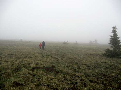 As always, bring good raingear to the mountain.