
|
|
Route |
|---|---|
|
|
55.39896°N / 3.35158°W |
|
|
Hiking |
|
|
Spring, Summer, Fall, Winter |
|
|
Most of a day |
|
|
No great difficulties except peat bogs and steep ascents/descents on ridges |
|
|
Overview:-
After adding my Moffat Hills Area page to the Summitpost website I thought this route was just right for anyone who wants to venture into these hills.Within the wilds of the Moffat Hills there is a route up on to the highest summit of White Coomb that if done in the best of weather is totally unforgettable. The route takes you up via one of the range/areas greatest ridges called Saddle Yoke and the route can be turned into a pleasent circular route from White Coomb by returning down via the great ridge of Carrifran. The other option is the route can be in a reverse direction as in up via Carrifran and return via Saddle Yoke. The choice is yours…?
Parking for the route is available along side the A708 road between the points of Capplegill and Carrifran. Very little of this route needs to be done on the road as the verge along side the A708 is extensive. It is best to keep off the road itself anyway as some people do drive like nutters along here. Once off the road and on the hills though no worries.

  |
Getting there:-
The start of this route is accessed via the A708 road that links the towns of Moffat and Selkirk via Moffat Dale, St Mary's Loch and Cappercleuch.Moffat can be easily accessed from junction 15 on the main A74(M) motorway that links the M6 at Carlisle in England with Glasgow in Scotland.
Selkirk can be easily accessed from the A7 road that links Hawick and Galashiels with Edinburgh and Carlisle. Selkirk can also be accessed via Galashiels from the A68 road linking Newcastle in England with Edinburgh in Scotland.
The start of the route is about 6 miles east on the A708 from Moffat.
The start of the route is about 30miles west on the A708 from Selkirk.
Navigation with Ordnance Survey Maps:-
The route falls into the area of the Moffat Hills which strangely falls across more than one Landranger 1:50 000 Ordnance Survey map but is covered across the area of four different sheets. This can make things difficult carrying loads of maps but Ordnance Survey have a 1:25 000 map that covers the complete area available in both paper sheet and laminated waterproof plastic. Maps for the area are listed below with details of areas they cover.
Ordnance Survey 1:50 000 Landranger series:-
Landranger 72 Upper Clyde Valley – Biggar and Lanark
Covers Tweedsmuir and Talla Reservoir
Landranger 73 Peebles, Galashiels & Selkirk – Tweed Valley
Covers Cappercleuch and St Mary’s Loch
Landranger 78 Nithsdale & Annandale – Sanquhar & Moffat
Covers Moffat town Moffat Dale, Annan Dale and the summit of Hart Fell
Landranger 79 Hawick & Eskdale – Langholm
Covers Loch of the Lowes, Moffat Dale, Loch Skeen / Skene and the summits of Lochcraig Head and White Coomb.
Ordnance Survey 1:25 000 Explorer series:-
Explorer 330 Moffat & St Mary’s Loch – Megget Reservoir
Covers the complete area of the Moffat Hills along with the Ettrick Hills in the south region and part of the Manor Hills with Broad Law in the north region.
Ordnance Survey 1:250 000 Road series:-
Road map 3 Southern Scotland and Northumberland
Covers the roads from the northern reaches of England around Carlisle across to Newcastle. The map also covers the southern area of Scotland down from Oban and Dundee.
Ordnance Survey Website Link:-
Ordnance Survey
Route Description:-
 Saddle Yoke Ridge
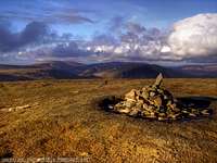 White Coomb Summit Cairn
 Carrifran Ridge
The start of the route is near the village of Capplegill from the track that leads off the A708 road in Moffat Dale near the point where the river of Black Hope Burn crosses.
streetmap-link to start of route NT 147 098
The track here leads off into the vast walls of the glacial valley of Black Hope. Instead of taking the track up Black Hope valley, from the start point take the direct route up the ridge towards the tops of Saddle Yoke and Under Saddle Yoke. This is quite a steep ascent so take it easy in the worst of weather. The views you get looking up the valley of Black Hope whilst ascending Saddle Yoke are very impressive.
streetmap-link to Saddle Yoke NT 144 123
From the summit of Saddle Yoke you follow down to the water table and walk round the edge of the crags Raven Craig. Once at Raven Craig the main dodgy part of this walk is to confront the horrible peat bogs of the Rotten Bottom. These can under certain conditions be very dangerous.
streetmap-links to Rotten Bottom NT 145 144
After crossing the wet flat intermediate and boggy land of the Rotten Bottom peat bogs you head on in a north, north-east direction between the water table point and out onto the summit top of Firthhope Rig. From Firthhope Rig White Coomb is a short walk about 1-kilometre in an easterly direction.
streetmap-links to Firthhope Rig NT 153 153
streetmap-links to White Coomb NT 163 150
Welcome to the summit of White Coomb:-
After the great route up you are now on the fine summit of White Coomb. From here you can sit, relax and take in the great views and enjoy being on the highest summit at 821 metres of this fine range/area of the Moffat Hills. There is a lot more information available about the Moffat Hills and White Coomb from these summitpost links:-
summitpost-link to Moffat Hills page
summitpost-link to White Coomb page
The return journey can be done via the great ridge of Carrifran which at its highest point of 757 metres is called Carrifran Gans.
From White Coomb you head in a south-west to south direction along the water table and out on to the ridge of Carrifran. From the summit point of Carrifran Gans the views across Carrifran Glen to the neighbouring ridge of Saddle Yoke are very impressive and when descending from Carrifran Gans down the Carrifran ridge the scale of this glacially cut valley is immense and a photo just cannot do it justice.
streetmap-link to Carrifran Gans NT 159 138
The descent from Carrifran is very steep and can be dodgy under bad weather conditions. The best way of getting back down into the valley of Moffat Dale is to follow the fence line down the ridge. The fence line takes you down along side a wooded area all the way to the main A708 road.
streetmap-link to end of route NT 161 117
 Carrifran from Saddle Yoke
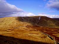 Firthhope Across Rotten Bottom
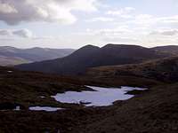 Saddle Yoke from Rotten Bottom
Essential Gear:-
Just a good pair of boots, waterproofs and a pack lunch. If you walk these hills in the winter make sure you also carry an ice axe and crampons. In the worst of weather conditions such as fog, low cloud and mist good navigation skills will be required with Ordnance Survey maps a compass and use of a GPS.Forward planning is also another major requirement.
Always inform somebody of your route giving details of your start time and when you expect to finish. If you run late try calling via your mobile but mobile service is not always great out here in the steep valleys. When you can make contact as soon as possible.
Make sure when you leave for your trek you have everything you require.
The weather can play a major part in the way your day goes. These Moffat Hills are isolated and the weather here can change in minutes.
The BBC 5-Day weather forecast is via this link:-
Moffat BBC 5-Day Weather
Bed and Breakfast - Accommodation and Camping:-
 A fine view from White Coombs summit with Broad Law and its radio towers dominating the picture
The area surrounding these Moffat Hills has many market towns that offer the services of hotels and bed and breakfasts etc:-
These are just some links for the town of Moffat area:-
Moffat Bed and Breakfast GOOGLE Search:-
BedandBreakfast-Directory.co.uk ( Moffat )
Moffat Camping GOOGLE Search:-
ukcampsite.co.uk ( Moffat )
Camping is also available in the wilds of the hills but look after the countryside whilst out there.
More about wild camping by searching on this site:-
Useful Links:-
Local Councils:-Dumfries and Galloway Council
Scottish Borders Council
Websites:-
Gazetteer for Scotland
A web site with more about Moffat
Moffat Mountain Rescue Team
National Trust For Scotland
National Trust Scotland
www.grough.co.uk
Grough
The above link has some information on walks from the Grey Mares Tail and Moffat Dale.