


asmrz - Apr 14, 2005 5:52 pm - Voted 10/10
What a spot! How was it?I just noticed you guys did the Winter Route. Doug talked about going up there earlier in the season, but the conditions were not quite right. How did it go? Thanks, Alois.

travelin_light - Apr 15, 2005 12:43 pm - Hasn't voted
Re: What a spot! How was it?ya! what did you think? i was just up last weekend (4/9 and 4/10) with my buddy scottie nelson and we managed to pull it off. we had to bivy about 500 feet from the top saturday night, a little chilly. overall the climbing was great still some snowy spots with water on some of the rock pitches near the top. made it back to the stone house sun afternoon. the decent only took us about 3 1/2 hrs. did you guys make it in a single push? how was the decent?

Sam Mills - Apr 19, 2005 1:05 am - Hasn't voted
Re: What a spot! How was it?Alois and Travelin,
What we climbed was fun. We bailed at the top of the second couloir, but only because I was too shitty of a climber to continue on 5.7 rock with mountaineering boots and a full pack. Doug wanted to keep going, and has the skill to climb at that level, but was gracious enough to turn around. One of several reasons I enjoy climbing with him...no ego hang-ups.
Travelin, Did you get any pictures of the upper pitches? Now I'm curious to see what they looked like.
Thanks, Sam
travelin_light - Apr 19, 2005 12:47 pm - Hasn't voted
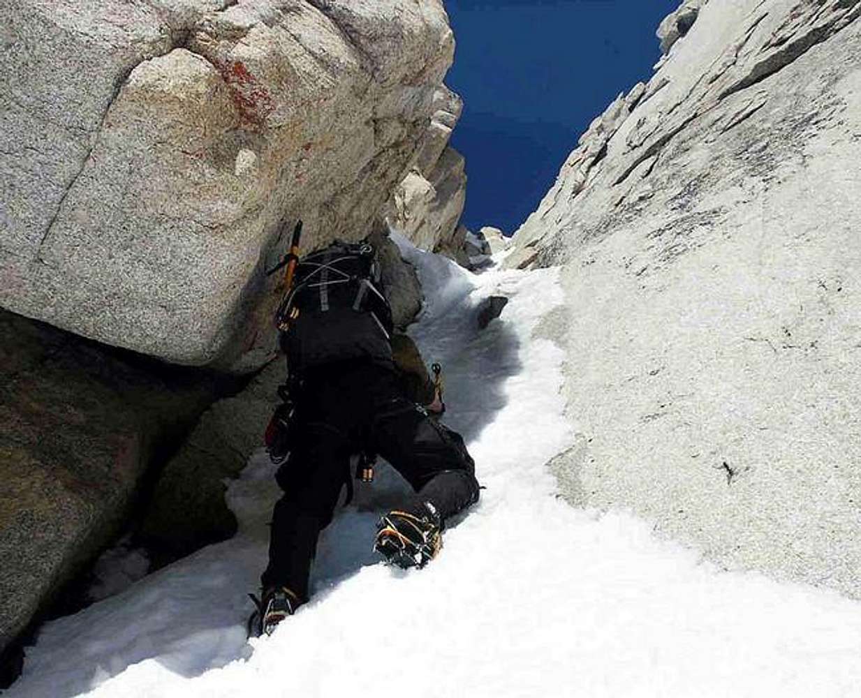
Re: What a spot! How was it?the upper rock pitches were rough. we started them in the afternoon with no sun, my hands got wet and couple fingers froze together for a second, barely got them warmed up. ended having to bivy b/c it was just too darn cold to climb rock. we found a nice ledge and finished in the morning sun. we lost some time b/c we had to haul the leaders pack a few times. there is a 5.7 face and a 5.8 chimney you have to negotiate so defintely bring your rock shoes (pro is poor). my partner has the pics i will get him to post some up. i am not sure how many we have of the rock though. we followed the windhorse and direct south face topos after the notch rappel. you guys have a nice pic of the icy area. there is potential for a big ice section if the conditions are right about half way up. how did it look to you guys?
asmrz - Apr 20, 2005 11:16 am - Voted 10/10
Re: What a spot! How was it?Traveling Light:
The ice pitch can indeed form as a great 200 foot steep and thin ice pitch. I climbed it in early January many years ago and it was incredible pitch,(two tools and all). I hear that in the last 10 years (I climbed it in early 80s) due to temperature changes, it is very intermittent in forming. Somewhere in my post, I have home made topo of the upper face above the Winter Route Notch, which shows the Beckey exit as well as couple of variation which are a bit cleaner higher up. The face is awesome above the notch, I agree. I still think this route is one great introduction into winter alpine climbing in the Sierra? Would you agree?

poorboy44 - Apr 26, 2005 1:32 pm - Hasn't voted
Re: What a spot! How was it?Hello Alois!
Does the 200 foot ice pitch form up below the notch? We were speculating that a good ice pitch might also form up over the rock slabs to the right of the first rock band.
FYI from the notch we climbed up the 5.7+ quartz dike (great pitch by the way), then traversed over and bivied on the sandy ledges. The next morning we finished on your variation -- 1 pitch 5.7 to the base of the chimney, then 1 pitch up the 5.8 chimney, then 1-2 easy pitches up the ridge to the top.
I agree, the Winter Route is a great climb and probably the most accessible winter alpine route in the Sierras.
poorboy44 - Apr 26, 2005 6:52 pm - Hasn't voted
Re: What a spot! How was it?Thanks Sam!
Wow all of that ice was gone by the next weekend, when we were up there. That ice looks great! How sick would it be if the entire Dynamo Hum dihedral iced up? (of course we did see some avys pour over that thing!) What do you think of the right hand couloir? It ends in a rock section at the top that would be pretty tough, but it might go.....
asmrz - Apr 27, 2005 11:16 am - Voted 10/10
Re: What a spot! How was it?The ice pitch below the notch does indeed form for about 175-200 feet. I saw it twice in early and mid January time frame. We needed two ice tools and crampons to climb the right hand side of the slab over very thin ice (2-3 inches) to get to the Notch. I was there many years ago, who knows how the increase in temperatures affected forming of the ice. The picture of Doug above shows much less ice in the spot where I believe the ice starts. You did the South Face variation above the Notch, I think it's much cleaner than hiking up the Beckey/Bjornstad Ledges and Tension traversing into the uggly, dirty gully to the right. What you climbed is in my opinion, much cleaner and better way, even if it is "our" variation on the finish. I have been saying it for ages, this is the most accesible training route for winter alpinists in the Sierra! Thanks for sharing your experience.


Comments
Post a Comment